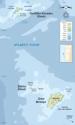
Berlengas
The Berlengas are a Portuguese archipelago consisting of small atlantic islands 10 to 17 kilometres (6.2–10.6 miles) off the coast of Peniche, Portugal, in the Oeste region. These islands were traditionally known to British mariners as "the Burlings".[1][2][3][4] The only inhabited island is its largest island, Berlenga Grande, although there is currently no permanent habitation in the archipelago. The other islands are grouped into two groups of islets, the Estelas Islets and the Farilhões-Forcados Islets.
| Native name: Arquipélago das Berlengas | |
|---|---|
.jpg.webp) Panoramic view of Berlengas islands. | |
 Location of the archipelago of the Berlengas | |
| Geography | |
| Location | Atlantic Ocean |
| Coordinates | 39.45°N 9.53°W |
| Area | 1.04 km2 (0.40 sq mi) |
| Length | 1.99 km (1.237 mi) |
| Width | 8.57 km (5.325 mi) |
| Highest elevation | 88 m (289 ft) |
| Administration | |
| Region | Centro |
| Municipality | Peniche |
| Demographics | |
| Population | no permanent habitation |
History

Human occupation on Berlenga Grande dates back to antiquity: the islands are referred to in Ptolemy's Geography as Λονδοβρίς (Londobris).[5] Much later it was referred to as the island of Saturno by Roman geographers, and was visited successively by Muslims, Vikings and privateers.
The islands are thought to be a former sacred place adopted by the phoenicians in the first millennium AD where the cult of Baal-Melqart was celebrated.[6]
In 1513, with the support of Queen Eleanor of Viseu, monks from the Order of São Jerónimo established a settlement on the island to offer assistance to navigation and victims of frequent shipwrecks. The monastery founded there (the Monastery of the Misericórdia da Berlenga), remained until the 16th century, when disease, lack of supplies and poor communication (due to constant inclement weather) forced the monks to abandon their service on the island.
After the Portuguese Restoration War, during the reign of King John IV, the Council of War determined that the demolition of the monastery ruins and the use of their rocks to build a coastal defense would help protect the coastal settlements; the Fort of São João Baptista das Berlengas was constructed from the remnants of the monastery ruins. By 1655, it had already, during its construction, resisted an assault by three Barbary coast pirates.
The island's lighthouse (dubbed Duke of Braganza by locals) was constructed in 1841.[7] In the 20th century a solar panel was installed in the lighthouse's 29-metre (95 ft) column, providing a 50-kilometre (31 mi) field of vision.
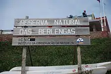
The International Coordinating Council of UNESCO’s Man and the Biosphere Programme (MAB), meeting in Dresden (Germany) from 28 June to 1 July, while adding 18 new sites, included the Berlengas to the World Network of Biosphere Reserves (WNBR): in a statement on 30 June 2011, the list of classified reserves were presented.[8]
Geography
.jpg.webp)
The archipelago is made up of the largest island, Berlenga Grande, and two groups of smaller islets, the Estelas Inlets and the Farilhões-Forcados Islets. As the archipelago has been declared a reservation area for the protection of the local fauna (primarily sea birds), it is only visited by scientists and, in the summer, by a small number of tourists.[9]
There is little soil on the rocky archipelago, so little plant life is supported.[10] Sea birds and marine life, such as mackerel, mullet, and swordfish are abundant.[10]
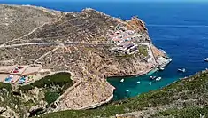
Berlenga Grande
.jpg.webp)
At 1.5 kilometres (0.9 mi) long and 0.8 kilometres (0.50 mi) wide, Berlenga Grande is the largest of the islands of the Berlengas Archipelago.[10] At its highest, it rises to 88 metres (289 ft) above sea level. The island has a number of notable caves, including Gruta Azul (English: "Blue Grotto") and Furado Grande (English: "Big Hole"). The Furado Grande is a natural tunnel 70 metres (230 ft) wide and 20 metres (66 ft) tall which crosses through the entire island before opening up into a dramatic bay.[9][10]
The Fort of São João Baptista (English: "Fort of St. John the Baptist") is located in the waters off the southeastern coast of Berlenga Grande, on a small islet connected to the island by a causeway/arch-bridge and anchorage to the north.[11] It has been retrofitted as a rest house for tourists to stay at while visiting the islands.[9]
Farilhões-Forcados Islets
The Farilhões-Forcados Islets are uninhabited islands located nortwest of Berlenga Grande.
Climate
The Berlengas have a Mediterranean climate (Köppen: Csb) dominated by the Atlantic, especially on the northern and northwestern coasts, where strong winds are felt. Heavy rains in winter alternate with periods of drought, between spring and autumn.
The climate of the archipelago is strongly influenced by the winds, very strong on the north-facing cliffs and more moderate on the southern coasts. These wind currents affect the distribution of flora and fauna in the islands. This climatic feature endows the archipelago with a unique ecosystem, both on land and at sea level.[12]
The presence close to the mainland, whose coast is oriented north-south, also strongly influences the climatic characteristics of the island, especially in summer. In this season, the differential warming of the sea and the land causes the formation of a sea breeze during the day. This breeze strengthens the main wind current associated with the Azores high pressure system and gives rise to a wind regime known as the Nortada. These winds push surface waters offshore, causing warm surface waters to replace cold waters from deeper layers of the water in an upwelling process. This phenomenon causes frequent mists during summer and results in nutrient enrichment of surface water.[13]
Average monthly temperatures in summer are cool (below 20 °C (68 °F)) and highs rarely exceed 32 °C (90 °F).[14][13] In winter, the monthly averages remain high (above 12 °C (54 °F)) and the minimum above 10 °C (50 °F).[14] The thermal amplitude (both diurnal temperature variation and yearly temperature variation) therefore remains moderate.[13]
Due to generally cloudy conditions in the winter and the summer morning fog, the archipelago as a relatively low number of sunshine hours, though clear sky afternoons are frequent in the summer.
Averages for the closest point on the mainland to the islands, Cabo Carvoeiro, are expressed in the climate box below:
| Climate data for Cabo Carvoeiro, Peniche, 1971-2000 normals and extremes | |||||||||||||
|---|---|---|---|---|---|---|---|---|---|---|---|---|---|
| Month | Jan | Feb | Mar | Apr | May | Jun | Jul | Aug | Sep | Oct | Nov | Dec | Year |
| Record high °C (°F) | 20.0 (68.0) |
22.0 (71.6) |
25.5 (77.9) |
28.5 (83.3) |
31.0 (87.8) |
30.5 (86.9) |
31.0 (87.8) |
30.2 (86.4) |
31.5 (88.7) |
30.5 (86.9) |
25.0 (77.0) |
21.2 (70.2) |
31.5 (88.7) |
| Average high °C (°F) | 14.2 (57.6) |
14.5 (58.1) |
15.5 (59.9) |
15.9 (60.6) |
17.2 (63.0) |
19.1 (66.4) |
20.3 (68.5) |
20.7 (69.3) |
20.6 (69.1) |
18.9 (66.0) |
17.0 (62.6) |
15.1 (59.2) |
17.4 (63.4) |
| Daily mean °C (°F) | 11.7 (53.1) |
12.2 (54.0) |
13.2 (55.8) |
13.7 (56.7) |
15.2 (59.4) |
17.1 (62.8) |
18.3 (64.9) |
18.7 (65.7) |
18.4 (65.1) |
16.7 (62.1) |
14.6 (58.3) |
12.7 (54.9) |
15.2 (59.4) |
| Average low °C (°F) | 9.2 (48.6) |
9.9 (49.8) |
10.8 (51.4) |
11.6 (52.9) |
13.3 (55.9) |
15.2 (59.4) |
16.4 (61.5) |
16.6 (61.9) |
16.2 (61.2) |
14.5 (58.1) |
12.2 (54.0) |
10.3 (50.5) |
13.0 (55.4) |
| Record low °C (°F) | 0.0 (32.0) |
1.1 (34.0) |
0.0 (32.0) |
4.0 (39.2) |
6.0 (42.8) |
9.0 (48.2) |
7.4 (45.3) |
10.5 (50.9) |
10.5 (50.9) |
6.8 (44.2) |
5.0 (41.0) |
0.9 (33.6) |
0.0 (32.0) |
| Average rainfall mm (inches) | 78.8 (3.10) |
69.8 (2.75) |
40.6 (1.60) |
51.8 (2.04) |
44.4 (1.75) |
17.7 (0.70) |
5.7 (0.22) |
9.1 (0.36) |
25.3 (1.00) |
76.2 (3.00) |
83.8 (3.30) |
88.1 (3.47) |
591.3 (23.29) |
| Average rainy days (≥ 0.1 mm) | 13.1 | 12.3 | 10.0 | 12.2 | 9.1 | 4.9 | 2.3 | 3.0 | 6.1 | 11.1 | 11.9 | 13.6 | 109.6 |
| Average relative humidity (%) (at 9:00 UTC) | 82 | 81 | 80 | 80 | 83 | 85 | 88 | 89 | 88 | 85 | 82 | 82 | 84 |
| Mean monthly sunshine hours | 132.6 | 122.1 | 172.8 | 194.1 | 223.0 | 222.7 | 245.0 | 253.9 | 196.0 | 171.1 | 136.2 | 122.3 | 2,191.8 |
| Source: Instituto de Meteorologia[15] | |||||||||||||
| Jan | Feb | Mar | Apr | May | Jun | Jul | Aug | Sep | Oct | Nov | Dec | Year | |
|---|---|---|---|---|---|---|---|---|---|---|---|---|---|
| Cabo Carvoeiro[15] | 19.6 | 19.7 | 19.2 | 19.0 | 18.1 | 16.9 | 17.3 | 16.3 | 15.2 | 16.8 | 18.4 | 20.0 | 18.0 |
Terrestrial biome
Flora
The flora of the Berlengas mainly consists of bushes and grasses, adapted to the strong winds, high aridity and salinity, some of them are common on the coastal mainland, others are endemic to the islands. There are two known endemic species to the islands, Armeria berlengensis and Pulicaria microcephala; and two subspecies, Echium rosulatum subsp. davaei and Herniaria lusitanica subsp. berlengiana.[16][17]
There are around 100 different plant species present on the archipelago.[17]
Human presence led to the introduction of exotic species, like the ice plant and small mammals like the European rabbit and the black rat who work to diminish the native population.[16][17]
Fauna
There are two species of lizard in the islands, the Carbonell's wall lizard (subs. berlengensis) and the ocellated lizard, although this last one is residual and is only seen in restricted areas of the islands such as caves and is thought to be different from the continental relatives, showing different morfological traits and demeanor. [16][18]
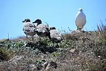
The Berlengas archipelago is an important breeding area for seabirds such as the lesser black-backed gull and the yellow-legged gull, whose population increased dramatically due to artificial feeding and has become a serious problem in some cases, and land birds like the black redstart and the peregrine falcon.[18] It is also in the southernmost range of the common murre (adopted as the symbol of the nature reserve)[18] and is one of the few breeding locations of the band-rumped storm petrel.
A new endemic species, Oestophora barrelsi spec. nov was described in 2015.[19]
Marine biome
The Berlengas archipelago is situated off of Peniche, south of the Nazaré Canyon and on the edge of the continental shelf (in Farilhões Islets) on a maritime zone known by its relatively high biological productivity, acting as a meeting point between coastal and oceanic fish species. On the other hand, the upwelling currents originating in deep waters contribute to the development of an aquatic fauna with evident commercial interest. Its variety of fish and marine mammals, marine plants and other marine organisms as led to its classification as a marine reserve.[18]
Fish
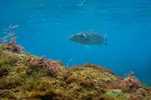
The water around the islands hosts a great variety of fish, at least 44 species are known from two study expeditions.[20] The most frequently observed fish is the common two-banded sea bream and the ballan wrasse, along with the European bass, the red porgy, the gilt-head bream and the dusky grouper, frequent on Farilhões Islets.[18]
In the '50s the islands were an important spawning ground for school sharks.[18]
Marine mammals
The oceanographic conditions of the archipelago commonly lead to an abundant ichthyofauna, represented by sardines and other species that feed on plankton. This attracts a lot of marine mammals, mainly cetaceans, whose species include the common dolphin, the common bottlenose dolphin, the harbour porpoise, the striped dolphin, the common minke whale and the Cuvier's beaked whale.[18]
Wrecks
A number of ships have wrecked on the Berlengas throughout documented history.
In 1808, HMS Milbrook wrecked on Berlenga Grande in a gale, though without loss of life.[21]
Culture
Berlenga Grande did star in a pre-revolutionary Portuguese movie called O Rei das Berlengas (English: The King of the Berlengas), a comedy about someone who decides to become king of the said archipelago. In this movie, several people, tourists and residents from the nearby towns, attempt to declare the independence of the islands, and declare themselves as king, prince or president of the Berlengas. These declarations and liberation armies are nothing more than fiction intended for amusement.
See also
References
- "Wreck Report for SS Corsica 1881" (PDF). Archived from the original (PDF) on 2015-09-24. Retrieved 2012-04-23.
- "Wreck Report for Brixham 1884". Archived from the original on 2015-09-24. Retrieved 2012-04-23.
- "Catalog of the latest and most approved Charts, Pilots and Navigation Books, published 1 March 1817, page 4. Item 62". Imray, Laurie, Norie and Wilson, ltd. 1817. Retrieved October 6, 2020.
- "WRECK OF THE DORUNDA. (5 October 1894)". The Brisbane Courier. Retrieved October 6, 2020.
- The Geography of Claudius Ptolemy
- "História e Cultura". ICNF. Retrieved 5 November 2020.
- "Dissertação de Mestrado em Cidadania Ambiental e Participação" (PDF). António João Farinha Ribeiro dos Santos. Retrieved October 6, 2020.
- UNESCO, ed. (30 June 2011). "18 new Biosphere Reserves added to UNESCO's Man and the Biosphere (MAB) Programme". Paris, France: UNESCO/Natural Sciences UNESCOPRESS. Retrieved 30 June 2011.
- Portugal, TCP/ARPT Centro de. "Berlengas • Centro de Portugal". Centro de Portugal. Retrieved 2017-02-21.
- Scheffel, Richard L.; Wernet, Susan J., eds. (1980). Natural Wonders of the World. United States of America: Reader's Digest Association, Inc. p. 78. ISBN 0-89577-087-3.
- "Monumentos". Archived from the original on 2016-03-05. Retrieved 2017-02-21.
- "Climate of the Berlengas (in Portuguese)". NOVA University Lisbon. Retrieved 25 January 2021.
- "Berlengas application file for UNSECO biosphere reserve status" (PDF). Retrieved 25 January 2021.
- "Portal do Clima". IPMA. Retrieved 25 January 2021.
- "Climate normals Cabo Carvoeiro, Peniche" (PDF). Instituto de Meteorologia.
- "Reserva Natural das Berlengas" (PDF). João Dias, Nelson Silva, Eva firme, Nuno Miranda. Retrieved October 5, 2020.
- "Flora da Reserva Natural das Berlengas". ICNF. Retrieved October 5, 2020.
- "Fauna da Reserva Natural das Berlengas". ICNF. Retrieved October 5, 2020.
- "A new Oestophora (Gastropoda, Eupulmonata, Trissexodontidae) from Ilha da Berlenga, Portugal". Adriaan Hovestadt & Theo E.J. Ripken. Retrieved October 6, 2020.
- "Fish diversity in the Berlengas Natural Reserve (Portugal), a marine protected area". Nuno Vasco-Rodrigues et al. Retrieved October 5, 2020.
- Hepper, David J. (1994). British Warship Losses in the Age of Sail, 1650–1859, p. 123. Rotherfield: Jean Boudriot. ISBN 0-948864-30-3