Bhal Padri
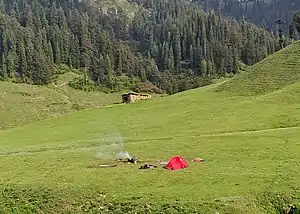
Bhal Padri (Kashmiri; Bal Padri) is a hill station situated above a group of small valleys[2] covered with dense forest[3] located in the Changa, Bhalessa.[1] area of Doda district. It borders Padri Pass, [lower-alpha 1][4] Bhaderwah at a distance of 4 kilometres (2.5 mi) northeast. Rivulets and streams flow through this valley.[2]
Bhal Padri
Bal Padri | |
|---|---|
Hill Station | |
 Bhal Padri is a natural landscape in Bhalessa | |
 Bhal Padri Bhal Padri in Doda, Jammu and Kashmir, India | |
| Coordinates: 32.943901°N 75.841578°E | |
| Country | India |
| State | Jammu and Kashmir |
| District | Doda |
| Tehsil | Gandoh (Bhalessa) |
| Elevation | 3,000 m (11,000 ft) |
| Languages | |
| • Official | Urdu |
| Languages | |
| • Local | Kashmiri, Urdu, Gojri, Bhalessi, Bhaderwahi |
Etymology
The name Bhal Padri is derived from the words, Bhal, which stands for Bhalessa, and Padri, the name of a nearby location popularly known as Padri Pass or Padri Top.[5]
About
Bhal Padri village is located to the northeast of Padri Pass, the highest point on the Bhaderwah-Chamba road.[6] Bhalessa is the nearest village on the northwestern side. People residing there belong to the Gujjar community[7] and live in mud houses without electricity. They use solar-powered lights.[8]
Tourism
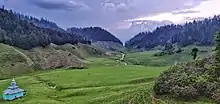
Bhal Padri is situated above a group of small valleys,[2] at an elevation of 11,000 feet (3,400 m)[1] above sea level. The landscape around it is characterised by streams flowing through meadows, surrounded dense forest.[3] The area is popular for trekking, as the town of Bhaderwah is located only 4 kilometres (2.5 mi) to the southwest.[9]
Route
Bhal Padri is located 66 kilometres (41 mi) from the headquarters of Doda district. It has been called the connecting link between Bhaderwah and Bhalessa.[5] While not connected directly to any road, some nearby roads include the Bhaderwah-Chamba road and the Gandoh-Khilotran road. The Bhaderwah-Chamba road at Padri leads to a path by which one may reach Bhal Padri after a 10–15 kilometres (6.2–9.3 mi) walk.[10] The Gandoh-Khilotran road is 12 kilometres (7.5 mi) from Bhal Padri on foot.[5]
The route starts from the nearest airport and provincial headquarters at Jammu.
The road starts from Jammu—Batote (via NH1A), changing route from Batote—Thathri (via NH244), turning right near Thathri-Kishtwar Bridge towards Thathri—Khilotran Highway till the Khilotran area of Gandoh Bhalessa, where a footpath leads towards Bhal Padri.[5]
Notes
- Padri Pass or Padri Top is tourist attraction located on Bhaderwah-Himachal Pradesh road
References
- "Adventures". www.doda.nic.in. Retrieved 13 July 2020.
- Chahal, Hardeep; Jyoti, Jeevan; Pereira, Vijay (28 Feb 2018). Sustainable Business Practices for Rural Development: The Role of Intellectual Capital. Palgrave Macmillan. p. 126. ISBN 978-981-13-9298-6. OCLC 1157092488. Retrieved 13 Jul 2020.
- "Bhal Padri Gorgeous Valley Comprising Of Innumerable Tiny Valleys". www.chenabvalley.in. 27 Jun 2020. Retrieved 13 July 2020.
- "Bhal Padri, Doda". www.nativeplanet.com. Retrieved 11 Jul 2020.
- Rather, Usama. "Bhal Padri". Retrieved 13 July 2020.
- "PADRI". Kashmir Hills. Retrieved 2020-07-19.
- Yousafzai, Tahir Nadeem Khan (11 Apr 2020). "Laborers on verge of starvation in Doda amid lockdown". Greater Kashmir. Retrieved 13 Jul 2020.
- "Army lights up 200 more mud houses in higher reaches of JK". India.com. 25 Aug 2018. Retrieved 13 Jul 2020.
- "A rare flower blooms amid slump in tourism in JKs Bhaderwah". Outlook (Indian magazine). 28 Jun 2020. Retrieved 13 July 2020.
- "Splendid Tourist Attractions". Bhaderwah Development Authority (J&K Tourism). Retrieved 13 July 2020.
