Bharte khunta
Bharte khunta is a mountain of the Garhwal Himalaya in Uttarakhand India.The elevation of Bharte khunta is 6,578 metres (21,581 ft) and its prominence is 280 metres (919 ft). It is 69th highest located entirely within the Uttrakhand. Nanda Devi, is the highest mountain in this category. It lies between Kirti Stambh and Kedarnath (mountain). Its nearest higher neighbor Kedarnath (mountain) 6,940 metres (22,769 ft) lies 3 km ESE. It is located 2.3 km SE of Kirti Stambh 6,279 metres (20,600 ft) and 6.9 km north lies Meru Peak 6,660 metres (21,850 ft).
| Bharte khunta | |
|---|---|
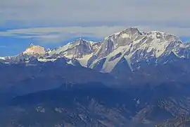 Kedarnath, Bharte khunta and Thalay Sagar from Kartik Swamy. (R-L) | |
| Highest point | |
| Elevation | 6,578 m (21,581 ft) [1] |
| Prominence | 280 m (920 ft) [1] |
| Coordinates | 30°50′39″N 79°02′05″E |
| Geography | |
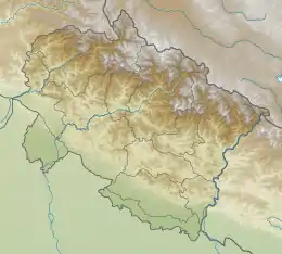 Bharte khunta Location in Uttarakhand | |
| Location | Uttarakhand, India |
| Parent range | Garhwal Himalaya |
| Climbing | |
| First ascent | INDO-TIBET BORDER POLICE claimed the first ascent of Bharte khunta led by B.C. Khulbey on 6 June 1975.[2] |
Climbing history
INDO-TIBET BORDER POLICE (ITBP) claimed the first ascent of Bharte khunta led by B.C. Khulbey on 6 June 1975. [2][3] A Spanish club de Esquí de La Molina, Girona, of Spain climbed Bharte khunta on 27 September climbers are Toni Bou, Kiko Colo, Josep Ximenis and Joan Sala.[4] Bharte Kunta was attempted by An Indian team led by Romesh Bhattacharjee from the Gangotri Glacier. They reached a high point of 6450 meters.[5]
Glaciers and rivers
Kirti Bamak lies on the NE side of Bharte khunta. On the SW side lies Bhartekunta Bamak. On the SE side lies Kedarnath Glacier. Kirti Bamak joins Gangotri glacier. Bhagirathi River comes out from the snout of Gangotri Glacier. Bhagirathi River is one of the main tributaries of river Ganga, which later joins Alaknanda river the other main tributaries of river Ganga at Dev Prayag and became Ganga there after.[6] On the other side Bhartekunta Bamak drain down to Bhilangana River which later joins Bhagirathi River near Tehri Dam. Mandakini River emerges from Kedarnath glacier and joins Alaknanda River at Rudra Prayag.
Neighboring peaks
neighboring peaks of Bharte khunta:
- Chaukhamba I: 7,138 m (23,419 ft)30°44′59″N 79°17′28″E
- Bhagirathi I: 6,856 m (22,493 ft)30°51′00″N 79°08′57″E
- Kedarnath Peak: 6,940 m (22,769 ft)30°47′42″N 79°04′10″E
- Kedarnath Dome: 6,831 m (22,411 ft)30°48′31″N 79°04′44″E
- Sumeru Parbat: 6,350 m (20,833 ft)30°46′15″N 79°07′24″E
- Mandani Parbat: 6,193 m (20,318 ft)30°44′01″N 79°11′57″E
See also
- List of Himalayan peaks of Uttarakhand
References
- "Bhartekunta". PeakVisor. Retrieved 14 May 2020.
- Chamoli, S.P. (1989). "CLIMBS OF INDO-TIBET BORDER POLICE : Himalayan Journal vol.45/21". www.himalayanclub.org. 45. Retrieved 14 May 2020.
- "AAC Publications - Asia, India–Garhwal, Peaks Climbed by the India-Tibet Border Police". publications.americanalpineclub.org. 1981. Retrieved 14 May 2020.
- "AAC Publications - Asia, India—Garhwal, Bharte Khunta". publications.americanalpineclub.org. 1988. Retrieved 14 May 2020.
- "AAC Publications - Asia, India—Kumaon and Garhwal, Bharte Khunte Attempt". publications.americanalpineclub.org. 1993. Retrieved 14 May 2020.
- "Devprayag | Times of India Travel". timesofindia.indiatimes.com. Retrieved 22 May 2020.