Birkeland, Agder
Birkeland is the administrative centre of the municipality of Birkenes in Agder county, Norway. The village is located on the eastern shore of the river Tovdalselva, across the river from the village of Flakk. The Norwegian National Road 41 runs through the village. The village is located about 30 kilometres (19 mi) northeast of the city of Kristiansand and about 14 kilometres (8.7 mi) northwest of the town of Lillesand.[3]
Birkeland | |
|---|---|
Village | |
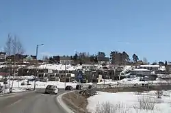 View of the village | |
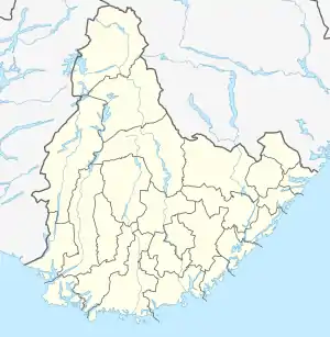 Birkeland Location of the village  Birkeland Birkeland (Norway) | |
| Coordinates: 58.3308°N 08.2323°E | |
| Country | Norway |
| Region | Southern Norway |
| County | Agder |
| Municipality | Birkenes |
| Area | |
| • Total | 2.07 km2 (0.80 sq mi) |
| Elevation | 51 m (167 ft) |
| Population (2019)[1] | |
| • Total | 2,962 |
| • Density | 1,431/km2 (3,710/sq mi) |
| Time zone | UTC+01:00 (CET) |
| • Summer (DST) | UTC+02:00 (CEST) |
| Post Code | 4760 Birkeland |
The 2.07-square-kilometre (510-acre) village has a population (2019) of 2,962 and a population density of 1,431 inhabitants per square kilometre (3,710/sq mi).[1]
The old Lillesand–Flaksvand Line was a railway line that passed through Birkeland, but it was closed in 1953. The newspaper Birkenesavisa is published in Birkeland.[4] The Southern Norway Folk high school is located in Birkeland and the Birkenes Church is located just south of Birkeland in the small village of Mollestad.
References
- Statistisk sentralbyrå (1 January 2019). "Urban settlements. Population and area, by municipality".
- "Birkeland, Birkenes (Aust-Agder)". yr.no. Retrieved 2017-08-19.
- Thorsnæs, Geir, ed. (2016-01-29). "Birkeland". Store norske leksikon (in Norwegian). Kunnskapsforlaget. Retrieved 2017-08-19.
- "Birkenesavisa: Om Birkenesavisa" (in Norwegian). Retrieved 2017-08-19.
