Black Jack, Queensland
Black Jack is a rural locality in the Charters Towers Region, Queensland, Australia.[2] In the 2016 census Black Jack had a population of 161 people.[1]
| Black Jack Queensland | |||||||||||||||
|---|---|---|---|---|---|---|---|---|---|---|---|---|---|---|---|
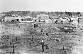 Black Jack, circa 1889 | |||||||||||||||
 Black Jack | |||||||||||||||
| Coordinates | 20.1688°S 146.1522°E | ||||||||||||||
| Population | 161 (2016 census)[1] | ||||||||||||||
| • Density | 1.272/km2 (3.294/sq mi) | ||||||||||||||
| Postcode(s) | 4820 | ||||||||||||||
| Area | 126.6 km2 (48.9 sq mi) | ||||||||||||||
| Time zone | AEST (UTC+10:00) | ||||||||||||||
| LGA(s) | Charters Towers Region | ||||||||||||||
| State electorate(s) | Traeger | ||||||||||||||
| Federal Division(s) | Kennedy | ||||||||||||||
| |||||||||||||||
It was formerly a mining town which is now abandoned.
Geography
Black Jack is a triangular-shaped locality. The Great Northern railway line forms the northern boundary of Black Jack. There are two railway stations within the locality, Wellington Yards railway station in the far north-east corner (on the outskirts of the suburban area of Charters Towers) and Southern Cross railway station on its north-west border.[3]
The Flinders Highway passes through the northern part of the locality, while the Diamantina Road forms its eastern boundary.[3]
Black Jack is approximately 350 metres above sea level rising to peaks in its south-west of 450 metres.[3]
History
The Black Jack P. C. mine produced large quantities of gold in 1886 and 1887 (known as the Black Jack Boom) but then produced very little in subsequent years.[4]
Black Jack Provisional School opened on 21 March 1887. It became Black Jack State School on 6 July 1891. It closed in 1949.[5]
In the 2016 census Black Jack had a population of 161 people.[1]
References
- Australian Bureau of Statistics (27 June 2017). "Black Jack (SSC)". 2016 Census QuickStats. Retrieved 20 October 2018.

- "Black Jack – locality in Charters Towers Region (entry 44535)". Queensland Place Names. Queensland Government. Retrieved 27 December 2020.
- "Queensland Globe". State of Queensland. Retrieved 24 July 2017.
- Marsland, L. W (1892), The Charters Towers gold mines : a descriptive and historical account of the town and gold field of Charters Towers, Queensland : with full and detailed particulars of the more important mines, and of all mining companies carrying on operations on the field : being a handbook of Charters Towers and a guide to mining investors, Waterlow Bros. & Layton, retrieved 24 July 2017
- Queensland Family History Society (2010), Queensland schools past and present (Version 1.01 ed.), Queensland Family History Society, ISBN 978-1-921171-26-0
Further reading
- Morton, C. C; Queensland. Dept. of Mines (1936), The Black Jack Gold Mine, Charters Towers, Dept. of Mines, retrieved 24 July 2017
