Black Volta
The Black Volta or Mouhoun[1] is a river that flows through Burkina Faso flowing about 1,352 km (840 mi) to the White Volta in Dagbon, Ghana.[2] The source of the Black Volta is in the Cascades Region of Burkina Faso, close to Mount Tenakourou, the highest point of the country. Further downstream it forms part of the border between Ghana and Côte d'Ivoire and Burkina Faso. Within Ghana, it forms the border between the Savannah Region and the Bono Region.[3][2] The Bui Dam is built on the river in Ghana.[2] The river bisects Bui National Park in Ghana.[4]
| Black Volta | |
|---|---|
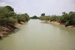 Black Volta (Mouhoun) near Dédougou, Burkina Faso | |
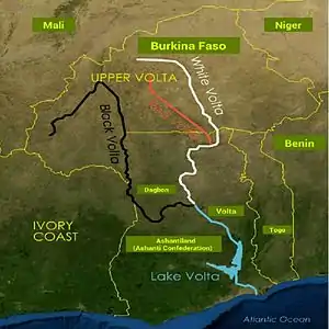 Black Volta shown in black | |
| Location | |
| Countries | |
| Physical characteristics | |
| Mouth | Volta River |
• location | Lake Volta |
• coordinates | 8°41′00″N 1°33′00″W |
| Length | 1,352 km (840 mi) |
| Basin size | 147,000 km2 (57,000 sq mi) |
| Discharge | |
| • location | Mouth |
| (Is home to many forms of wildlife that are unique to the part of the world) | |
References
- Amisigo, Barnabas Akurigo (2005). Modelling Riverflow in the Volta Basin of West Africa: A Data-driven Framework. Cuvilier. p. 27. ISBN 9783865377012. Retrieved 18 July 2018.
- "Ghana - Rivers and Lakes". www.countrystudies.us. Retrieved 2017-08-17.
- "CONFIRMED: Results of the 2018 Referendum on new regions". Graphic Online. Retrieved 2020-08-18.
- "Bui National Park". Ghana Wildlife Division. Retrieved 23 April 2018.
| Wikimedia Commons has media related to Black Volta River. |
This article is issued from Wikipedia. The text is licensed under Creative Commons - Attribution - Sharealike. Additional terms may apply for the media files.