Bocktschingel
The Bocktschingel is a mountain of the Glarus Alps, located on the border between the Swiss cantons of Uri and Glarus. It lies south-east of the Klausen Pass, on the range east of the Clariden.
| Bocktschingel | |
|---|---|
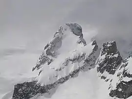 View from the Gemsfairenstock (north-east side) | |
| Highest point | |
| Elevation | 3,079 m (10,102 ft) |
| Prominence | 179 m (587 ft) [1] |
| Parent peak | Schärhorn |
| Coordinates | 46°50′57″N 8°53′37″E |
| Geography | |
 Bocktschingel Location in Switzerland | |
| Location | Uri/Glarus, Switzerland |
| Parent range | Glarus Alps |
References
- Retrieved from the Swisstopo topographic maps and Google Earth. The key col is located west of the summit at 2,900 metres.
This article is issued from Wikipedia. The text is licensed under Creative Commons - Attribution - Sharealike. Additional terms may apply for the media files.