Boult-sur-Suippe
Boult-sur-Suippe is a commune of the Marne department in northeastern France.
Boult-sur-Suippe | |
|---|---|
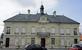 The town hall in Boult-sur-Suippe | |
Location of Boult-sur-Suippe 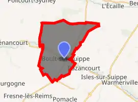
| |
 Boult-sur-Suippe  Boult-sur-Suippe | |
| Coordinates: 49°22′17″N 4°08′47″E | |
| Country | France |
| Region | Grand Est |
| Department | Marne |
| Arrondissement | Reims |
| Canton | Bourgogne |
| Intercommunality | CU Grand Reims |
| Government | |
| • Mayor (2008–2014) | Claude Scrabalat |
| Area 1 | 19.75 km2 (7.63 sq mi) |
| Population (2017-01-01)[1] | 1,705 |
| • Density | 86/km2 (220/sq mi) |
| Time zone | UTC+01:00 (CET) |
| • Summer (DST) | UTC+02:00 (CEST) |
| INSEE/Postal code | 51074 /51110 |
| 1 French Land Register data, which excludes lakes, ponds, glaciers > 1 km2 (0.386 sq mi or 247 acres) and river estuaries. | |
Geography
The commune is traversed by the Suippe river.
Population
| Year | Pop. | ±% |
|---|---|---|
| 1962 | 840 | — |
| 1968 | 974 | +16.0% |
| 1975 | 938 | −3.7% |
| 1982 | 899 | −4.2% |
| 1990 | 1,361 | +51.4% |
| 1999 | 1,353 | −0.6% |
| 2006 | 1,436 | +6.1% |
| 2009 | 1,612 | +12.3% |
History
Boult-sur-Suippe is about 64 kilometers (40 mi) from the Belgium border, and during World War I the village was positioned along the Western Front (World War I), and the German troops established a hospital in the village. A cemetery in the village was used by the Germans between October 1914 and October 1918, and was perhaps directly linked to the battles of Reims, also called the Second Battle of the Marne and surrounding forts. Recent archaeological investigations have discovered over 500 graves in the cemetery, some of them identified as German and English troops, a few who were listed as Missing in action.[2]
See also
References
- "Populations légales 2017". INSEE. Retrieved 6 January 2020.
- Urbanus, Jason 2016. "A Last Day, Reclaimed." Archaeology Magazine. November/December 2016. Pages 48-53.
| Wikimedia Commons has media related to Boult-sur-Suippe. |
| Authority control |
|
|---|
This article is issued from Wikipedia. The text is licensed under Creative Commons - Attribution - Sharealike. Additional terms may apply for the media files.