Bourne Eau
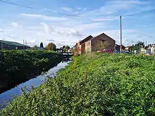
Bourne Eau is a short river which rises in the town of Bourne in Lincolnshire, England, and flows in an easterly direction to join the River Glen at Tongue End. It is an embanked river, as its normal level is higher than that of the surrounding Fens. It was navigable in the 18th and 19th century, but now forms an important part of the drainage system that enables the surrounding fen land to be used for agriculture.
Course
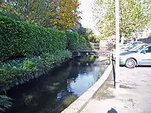
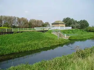
Bourne Eau rises in The Wellhead, otherwise known as St Peter's Pool, in Bourne, Lincolnshire.[1] The Wellhead is a natural artesian spring which once formed the source of the water defences of Bourne Castle as well as the power for the town's three mills.[1] On entering Bourne North Fen it follows an artificial course which it was given, probably, in the first half of the thirteenth century when the south Lincolnshire Fens ceased to be a Royal forest. Hitherto, it had occupied the channel known as the Old Ea which was of Roman date, most likely second century. The present course enters the River Glen at Tongue End, a name which derives from the low tongue of land within the enclosing banks of the rivers.
Apart from the spring, most of the water of the river is collected by the Car Dyke, which, near Bourne, is arranged to act as a catchwater drain, gathering the surface water of the upland and feeding it via the Bourne Eau and River Glen to the sea, without its entering The Fens.
History
From 1765, the north bank of the river was the responsibility of the Black Sluice Commissioners, a body which had been created by an Act of Parliament, to construct the Black Sluice where the South Forty-Foot Drain entered The Haven at Boston, and to supervise the drainage of the Fens feeding that system. The north bank was a serious problem, as it was built on a peat subsoil, and defied attempts to raise it, with the result that the Bourne Fens often flooded.[2] Improvements to the 3.5 miles (5.6 km) of river from the River Glen junction to the town of Bourne were authorised by an act of Parliament obtained on 29 March 1781, which suggested that the river had previously been navigable, but had become choked with mud. The act created a body of 12 trustees, who were empowered to maintain a channel which was 30 feet (9.1 m) wide by 5 feet (1.5 m) deep.[3] The navigation included two locks, one near the junction with the Glen, and the other near Bourne.[1]
In order to ease the problems caused by the north bank, the Black Sluice Commissioners negotiated with the Trustees to allow them to build a set of flood gates at Tongue End, where the river joined the Glen, and an overfall weir, which allowed surplus water to flow over the bank and into the Weir Dyke in Bourne Fen.[2] The self-acting doors were replaced by a sluice in the 1860s, which effectively brought navigation to an end,[1] and the sluice was replaced by a pumping station in 1966, which removed the need for the overfall weir.[2]
Etymology
Wheeler (1896) gives the name Bourne Old Ea to what is now the Bourne Eau and Bourne Ea or Brunne Ea to that part of the Glen downstream of Kate's Bridge. He then quotes Dugdale, and an act of Queen Elizabeth I:
- Brunne, River of, Brunne Hee,Burne Alde Ee. In Dugdale the Brunne Ee is describhed in the margin as 'now the Glene'...'Which had its course through the midst of the town of Pincbec.' The 'Ware' Dyke is described as extending along 'the river of Burne Ee to Godramscote' in a commission of Sewers held at Hempringingham in Queen Elisabeth's time.
[4]
The French-seeming spelling Eau is not unique in English river names. It appears to have arisen in the eighteenth century. The older spelling was Ea, from Old English ǣ (ultimately from PIE *hakʷā- "(moving) water"), see also Aach (toponymy) for more detail. Bourne "stream" is from Old English burne, burna ("spring, fountain"),
See also
References
- "Bourne Eau History". East Anglian Waterways Association.
- "History of the Draining of the Fens in the Black Sluice Area". The Black Sluice Internal Drainage Board. Archived from the original on 28 April 2011. Retrieved 19 December 2010.
- Priestley, Joseph (1831). Historical Account of the Navigable Rivers, Canals, and Railways, of Great Britain. p. 83.
- Wheeler M.Inst.C.E, William Henry (1896). A History of the Fens of South Lincolnshire, being a description of the rivers Witham and Welland and their estuary, and an account of the Reclamation, Drainage, and Enclosure of the fens adjacent thereto. (2nd ed.). J.M. Newcombe (Boston), Simpkin, Marshall & Co. (London). p. Appendix 1, p 7. doi:10.1680/ahotfosl2e.50358.