Brainerd, Kansas
Brainerd is an unincorporated community in Butler County, Kansas, United States. It is located on the north side of K-196 highway between the cities of Whitewater and Potwin.
Brainerd, Kansas | |
|---|---|
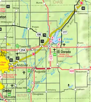 KDOT map of Butler County (legend) | |
 Brainerd  Brainerd | |
| Coordinates: 37°57′04″N 97°05′43″W | |
| Country | United States |
| State | Kansas |
| County | Butler |
| Township | Milton |
| Platted | 1885 |
| Named for | Elisha B. Brainerd (landowner) |
| Elevation | 1,384 ft (422 m) |
| Time zone | UTC-6 (CST) |
| • Summer (DST) | UTC-5 (CDT) |
| ZIP code | 67154 |
| Area code | 316 |
| FIPS code | 20-08200 [1] |
| GNIS ID | 473721 [1] |
History
Early history
For many millennia, the Great Plains of North America was inhabited by nomadic Native Americans. From the 16th century to 18th century, the Kingdom of France claimed ownership of large parts of North America. In 1762, after the French and Indian War, France secretly ceded New France to Spain, per the Treaty of Fontainebleau.
19th century
In 1802, Spain returned most of the land to France. In 1803, most of the land for modern day Kansas was acquired by the United States from France as part of the 828,000 square mile Louisiana Purchase for 2.83 cents per acre.
In 1854, the Kansas Territory was organized, then in 1861 Kansas became the 34th U.S. state. In 1855, Butler County was established within the Kansas Territory, which included the land for modern day Brainerd.
A post office was established in Holden on December 14, 1870, then renamed to Brainerd on January 25, 1886. The post office closed on August 31, 1907.[2]
Brainerd was platted in 1885 around a depot along the McPherson branch of the Missouri Pacific Railroad.[3] The community was named for Elisha B. Brainerd, an original landowner.[4] It quickly grew, including some businesses and houses from nearby community of Plum Grove.[5]
20th century
In 1961, Frederic Remington High School was built immediately north of Brainerd. Leading up to this new school, Whitewater, Potwin, Brainerd, Elbing, Furley, Countryside, and Golden Gate schools merged to form a joint rural high school. Heated opposition between Whitewater and Potwin occurred during the discussion for the location of the new high school. Rural voters pushed for a centralized location in neither town. A public vote was passed to build the new school near Brainerd.[6]
21st century
In 2006, the Remington Rock monument was built near the Frederic Remington High School.
Geography
Brainerd is located at 37°57′4″N 97°5′43″W (37.9511267, -97.0953122),[7] which is the north side of K-196 highway between the cities of Whitewater and Potwin.
Education
The community is served by Remington USD 206 public school district. The Remington High School mascot is a Bronco.
- Frederic Remington High School at 8850 NW Meadowlark Road, north of Brainerd.
- Remington Middle School at 316 E Topeka Street in Whitewater.
- Remington Elementary School at 200 E Ellis Avenue in Potwin.
Media
Print
- The Newton Kansan, regional newspaper from Newton.
- The El Dorado Times, regional newspaper from El Dorado.
- The Wichita Eagle, major regional newspaper from Wichita.
Radio
Goessel is served by numerous radio stations of the Wichita-Hutchinson listening market area,[8] and satellite radio. See Media in Wichita, Kansas.
Television
Goessel is served by over-the-air ATSC digital TV of the Wichita-Hutchinson viewing market area,[9] cable TV, and satellite TV. See Media in Wichita, Kansas.
Infrastructure
Transportation
K-196 highway runs along the south side of the community.
Utilities
- Internet
- Wireless is provided by Pixius Communications.
- Satellite is provided by HughesNet, StarBand, WildBlue.
- TV
- Satellite is provided by DirecTV, Dish Network.
- Terrestrial is provided by regional digital TV stations.
- Electricity is provided by Butler REC.
- Water is provided by Butler County Rural Water District #7 (map).
References
- "US Board on Geographic Names". United States Geological Survey. 2007-10-25. Retrieved 2008-01-31.
- "Kansas Post Offices, 1828-1961 (archived)". Kansas Historical Society. Archived from the original on October 9, 2013. Retrieved 5 June 2014.
- Mooney, Vol. P. (1916). History of Butler County Kansas. Standard Publishing Company. pp. 175.
- "Profile for Brainerd, Kansas". ePodunk. Retrieved 5 June 2014.
- New town of Brainerd and Potwin; The Peabody Gazette; Page 4 of June 11, 1885.
- USD 206 History
- U.S. Geological Survey Geographic Names Information System: Brainerd
- Wichita-Hutchinson Radio market.
- Wichita-Hutchinson TV market.
Further reading
- Plum Grove, Brainerd, Whitewater, and Potwin from 1870 to 1900; Roland H. Ensz; Emporia State University; 134 pages; 1970.
External links
- Historical
- Brainerd, Kansas - Time, Place and Memory on the Prairie Plains (A Brief History of the Brainerd Area)
- Frederic Remington Area Historical Society
- Maps
- Butler County maps: Current, Historic, KDOT
- Topo Map of Whitewater / Potwin / Brainerd area, USGS
Municipalities and communities of Butler County, Kansas, United States | ||
|---|---|---|
| Cities | 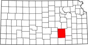 Map of Kansas highlighting Butler County | |
| Unincorporated communities | ||
| Ghost towns | ||
| Townships | ||
| Footnotes | †This populated place is designated a Census-Designated Place (CDP) by the United States Census Bureau, ‡This populated place also has portions in an adjacent county or counties. | |
| ||