Branford, Florida
Branford is a town in Suwannee County, Florida, United States. The population was 712 at the 2010 census.
Branford, Florida | |
|---|---|
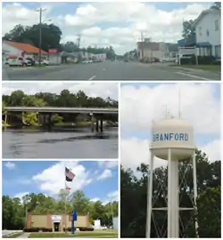 Top, left to right: Downtown Branford, Suwannee River, Branford Town Hall, Branford water tower | |
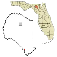 Location in Suwannee County and the state of Florida | |
| Coordinates: 29°57′42″N 82°55′38″W | |
| Country | United States |
| State | Florida |
| County | Suwannee |
| Area | |
| • Total | 1.11 sq mi (2.87 km2) |
| • Land | 1.11 sq mi (2.87 km2) |
| • Water | 0.00 sq mi (0.00 km2) |
| Elevation | 43 ft (13 m) |
| Population (2010) | |
| • Total | 712 |
| • Estimate (2019)[2] | 732 |
| • Density | 659.46/sq mi (254.64/km2) |
| Time zone | UTC-5 (Eastern (EST)) |
| • Summer (DST) | UTC-4 (EDT) |
| ZIP code | 32008 |
| Area code(s) | 386 |
| FIPS code | 12-08175[3] |
| GNIS feature ID | 0279335[4] |
| Website | townofbranford |
Geography
Branford is located at 29°57′42″N 82°55′38″W (29.961803, -82.927204).[5]
The town is located on the banks of the Suwannee River. U.S. Route 27 and U.S. Highway 129 intersect in Branford.
According to the United States Census Bureau, the town has a total area of 0.8 square miles (2.1 km2), all land.
Demographics
| Historical population | |||
|---|---|---|---|
| Census | Pop. | %± | |
| 1890 | 335 | — | |
| 1910 | 26 | — | |
| 1920 | 708 | 2,623.1% | |
| 1930 | 498 | −29.7% | |
| 1940 | 684 | 37.3% | |
| 1950 | 753 | 10.1% | |
| 1960 | 663 | −12.0% | |
| 1970 | 820 | 23.7% | |
| 1980 | 622 | −24.1% | |
| 1990 | 670 | 7.7% | |
| 2000 | 695 | 3.7% | |
| 2010 | 712 | 2.4% | |
| 2019 (est.) | 732 | [2] | 2.8% |
| U.S. Decennial Census[6] | |||
As of the census[3] of 2010, there were 712 people, 277 households, and 185 families in the town. The population density was 890 people per square mile (323.3/km2). There were 347 housing units at an average density of 386.1 per square mile (148.9/km2). The racial makeup of the town was 80.2% White, 6.9% African American, 0.8% Native American, 1.7% Asian, Hispanic or Latino of any race were 13.2% of the population.
Of the 277 households 35.7% had children under the age of 18 living with them, 40.4% were married couples living together, 20.6% had a female householder with no husband present, and 33.2% were non-families. 27.8% of households were one person and 14.8% were one person aged 65 or older. The average household size was 2.57 and the average family size was 3.06.
The age distribution was 30.8% under the age of 19, 6.6% from 20 to 24, 27.5% from 25 to 44, 21.5% from 45 to 64, and 13.7% 65 or older. The median age was 32.9 years.
The median household income was $32,679 and the median family income was $36,625. The per capita income for the town was $17,353. About 24.9% of families and 29.2% of the population were below the poverty line, including 29.4% of those under age 18 and 12.6% of those age 65 or over.
Branford is served by two Public Schools, Branford Elementary School and Branford High School.
A public library is open 6 days per week on Suwannee Avenue.
Branford Springs
On the Suwannee River, Branford Springs within the town is a popular diving spot.[7][8]
 Suwannee River Greenway
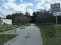 Suwannee River Greenway
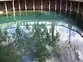 Branford Springs
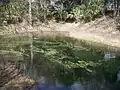 Branford Springs
References
- "2019 U.S. Gazetteer Files". United States Census Bureau. Retrieved July 2, 2020.
- "Population and Housing Unit Estimates". United States Census Bureau. May 24, 2020. Retrieved May 27, 2020.
- "U.S. Census website". United States Census Bureau. Retrieved 2008-01-31.
- "US Board on Geographic Names". United States Geological Survey. 2007-10-25. Retrieved 2008-01-31.
- "US Gazetteer files: 2010, 2000, and 1990". United States Census Bureau. 2011-02-12. Retrieved 2011-04-23.
- "Census of Population and Housing". Census.gov. Retrieved June 4, 2015.
- "Branford Springs". underwaterflorida. Retrieved May 18, 2012.
- "Branford Springs". apalacheehills.com. Archived from the original on September 1, 2012. Retrieved May 18, 2012.
External links
Municipalities and communities of Suwannee County, Florida, United States | ||
|---|---|---|
| City | 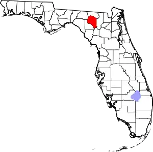 | |
| Town | ||
| Unincorporated communities | ||
| ||