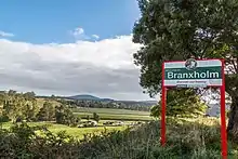
Branxholm, Tasmania
Branxholm is a scenic rural town on the banks of the Ringarooma River in north east Tasmania located 93 km north east of Launceston on the Tasman Highway. It is notable for its saw mill, hop fields and tourism. It has a sprawling street pattern which makes the small town spread across the valley floor.
History
The area was first settled by James Reid Scott who named it after a small village in his native Scotland. By 1870 there were only three buildings in the valley but three years later, with the discovery of tin, a shanty town had grown up. By 1877 the population was around 300. By 1883 the town had been proclaimed. Branxholm Post Office opened on 1 August 1876.[1]
Tin mining gradually declined to be replaced by timber cutting and in 1970 the first hop fields were planted.
Since the official opening of the Blue Derby Mountain bike trails in neighbouring Derby in 2015 tourism as an industry is becoming more important to the economy of Branxholm. In the few years since the opening of the trails new businesses catering to tourists have opened, including cafes and tourist accommodation.
For visitors
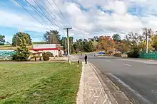
For visitors Branxholm's main shopping area provides an IGA supermarket, Cafe and Art Gallery, Italian-style restaurant, wood-fired pizza restaurant and the Elegant Imperial Hotel (circa 1907) with accommodation from $45 night, meals, bar and takeaway alcohol. There are several tourism and short-stay accommodation options in the town.
 Branxholm community riverwalk
The Branxholm community riverwalk is a great way to enjoy the river for fishing, swimming and picnics.
Close to the town Mount Horror, known for excellent scenic views, is surrounded by extensive pine and gum plantations. The Forestry Commission's fire tower is open to the public when attended in the summer.
Tin Mining History
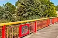 The red bridge in Branxholm commemorates the town's rich Chinese tin-mining history
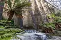 Mount Paris Dam near Branxholm in North East Tasmania
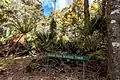 Briseis Water Race walking track
The red bridge in Branxholm was a community project completed in 2003 to commemorate the rich Chinese mining history of the town.
Water was needed for hydraulic tin-mining and the legacy mining holes, water races and dams are worth exploring. For example, the disused Mount Paris Dam, located on C425 road which has become a photographic icon on Instagram and the Briseis Water Race walking track.
The Briseis Race walking track is an easy walk that highlights the tin-mining history of Branxholm. This water race is an amazing feat of engineering. Commenced in 1901, it was hand-built by three gangs of approximately 100 men in each. It was constructed from either end of the 48 km length, simultaneously and section by section over a period of just 15 months. Water harnessed from behind Ringarooma was channelled along the race to Derby, to provide a minimum of 24 million gallons daily to the large scale hydraulic mining at the Briseis Tin Mine, with the first release of water taking three weeks to reach the mine! Today the visitor can ‘walk with history’ along the Great Briseis Water Race Walk at Branxholm, and take in the remains of four metre deep cuttings through solid rock, sections of original stonewalling, remains of timber trestle fluming structures, and many other insights into the character of those who undertook this mighty task.[2]
Rail Trail
Construction of the Dorset Rail Trail was a local Scottsdale Rotary Club project. The trail follows the old railway corridor from Tonganah to Tulendeena and hopefully later to Legerwood. The trail is used by cyclists, walkers and horse-riders. Each year in August the Trail Run and Ride competitive event is held. The event distances range from 56 km to 2 km, from Scottsdale township to the top of Billycock Hill and return.
Sport
The town used to have a football team in the NEFU (North Eastern Football Union).
Railway
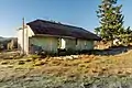 The old Branxholm railway station (now a hay barn) sits in a paddock on the outskirts of the town.
Branxholm was served by a branch railway line which extended from Launceston to Herrick, 4 km short of Moorina. The State rail connected Branxholm to its system in 1911.[3]
By 1978, the last passenger trains closed down in Tasmania and the rail network, including the Launceston-Scottsdale line, focused on carrying freight. By the early 1980s there were just three daily services between Scottsdale and Launceston transporting logs, woodchips and other goods however, by 2005, the line was closed.[4]
The railway to Branxholm closed in April, 1992.[5]
References
- Premier Postal History. "Post Office List". Premier Postal Auctions. Retrieved 16 June 2012.
- https://digitised-collections.unimelb.edu.au/bitstream/handle/11343/24292/305768_UDS2013255-13-0005.pdf
- "Archived copy". Archived from the original on 26 February 2011. Retrieved 2010-10-19.CS1 maint: archived copy as title (link)
- "Where did the North-East passenger trains go? - Tasmanian Times". tasmaniantimes.com. Retrieved 25 October 2018.
- Stokes, H.J.W.(1997)The North-eastern Line of the Tasmanian Government Railways Australian Railway Historical Society Bulletin, March;April, 1997 pp.67-77;107-121
