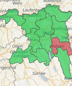
Bremgarten District
Bremgarten District is a Swiss district in the Canton of Aargau, corresponding to the valleys of the Reuss and Bünz rivers in the area known as the Freiamt.
Bremgarten District
Bezirk Bremgarten | |
|---|---|
District | |
| |
| Country | |
| Canton | |
| Capital | Bremgarten |
| Area | |
| • Total | 117.46 km2 (45.35 sq mi) |
| Population (2019) | |
| • Total | 78,158 |
| • Density | 670/km2 (1,700/sq mi) |
| Time zone | UTC+1 (CET) |
| • Summer (DST) | UTC+2 (CEST) |
| Municipalities | 22 |
Geography
Bremgarten District has an area, as of 1997, of 117.47 km2 (45.36 sq mi). Of this area, 48.7% is used for agricultural purposes, while 30.9% is forested. The rest of the land, (18.1%) is settled.[1]
Demographics
Bremgarten District has a population of 78,158 (as of 31 December 2019).[2]
As of 2000, there were 2,402 homes with 1 or 2 persons in the household, 11,781 homes with 3 or 4 persons in the household, and 9,773 homes with 5 or more persons in the household. The average number of people per household was 2.43 individuals.[1] In 2008 there were 10,969 single family homes (or 37.2% of the total) out of a total of 29,488 homes and apartments.[3] There were a total of 479 empty apartments for a 1.6% vacancy rate.[3]
Of the school age population (in the 2008/2009 school year), there are 5,276 students attending primary school, there are 1,992 students attending secondary school, there are 1,349 students attending tertiary or university level schooling, and there are 30 students who are seeking a job after school in the municipality.[1]
Economy
As of 2000 there were 33,414 residents who worked in the district, while 25,027 residents worked outside the Bremgarten district and 11,621 people commuted into the district for work.[4]
Religion
From the 2000 census, 32,805 or 53.2% were Roman Catholic, while 16,065 or 26.1% belonged to the Swiss Reformed Church. Of the rest of the population, there were 70 individuals (or about 0.11% of the population) who belonged to the Christian Catholic faith.[1]
Municipalities

| Crest | Name of municipality | Population (31 December 2019)[2] |
Area in km² |
|---|---|---|---|
| Arni | 1,868 | 3.37 | |
| Berikon | 4,756 | 5.38 | |
| Bremgarten | 8,211 | 11.36 | |
| Büttikon | 975 | 2.82 | |
| Dottikon | 3,891 | 3.89 | |
| Eggenwil | 1,034 | 2.46 | |
| Fischbach-Göslikon | 1,607 | 3.07 | |
| Hägglingen | 2,445 | 7.73 | |
| Islisberg | 631 | 1.65 | |
| Jonen | 2,183 | 5.70 | |
| Niederwil | 2,815 | 6.15 | |
| Oberlunkhofen | 2,035 | 3.25 | |
| Oberwil-Lieli | 2,457 | 5.35 | |
| Rudolfstetten-Friedlisberg | 4,508 | 4.90 | |
| Sarmenstorf | 2,929 | 8.30 | |
| Tägerig | 1,489 | 3.30 | |
| Uezwil | 488 | 2.45 | |
| Unterlunkhofen | 1,469 | 4.49 | |
| Villmergen | 7,472 | 11.94 | |
| Widen | 3,779 | 2.62 | |
| Wohlen | 16,613 | 12.48 | |
| Zufikon | 4,503 | 4.80 | |
| Total | 78,158 | 117.46 |
Mergers
The following changes to the district's municipalities have occurred since 2000:
- Hilfikon became part of Villmergen in 2010 (the area figure above includes Hilfikon).[5]
- On 1 January 2014 the former municipality of Hermetschwil-Staffeln merged into the municipality of Bremgarten (AG).[6]
References
- Statistical Department of Canton Aargau - Aargauer Zahlen 2009 (in German) accessed 20 January 2010
- "Ständige und nichtständige Wohnbevölkerung nach institutionellen Gliederungen, Geburtsort und Staatsangehörigkeit". bfs.admin.ch (in German). Swiss Federal Statistical Office - STAT-TAB. 31 December 2019. Retrieved 6 October 2020.
- Statistical Department of Canton Aargau (in German) accessed 20 January 2010
- Statistical Department of Canton Aargau-Bereich 11 Verkehr und Nachrichtenwesen (in German) accessed 21 January 2010
- Amtliches Gemeindeverzeichnis der Schweiz published by the Swiss Federal Statistical Office (in German) accessed 14 January 2010
- Nomenklaturen – Amtliches Gemeindeverzeichnis der Schweiz Archived 2015-11-13 at the Wayback Machine (in German) accessed 13 December 2014