Brentford Ait
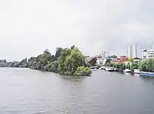
Brentford Ait is a long 4.572-acre (1.9 ha) uninhabited ait (river island) in the River Thames, with no buildings, on the Tideway near Brentford in London, England.
Ownership and size
It is administered by the London Borough of Richmond upon Thames and Port of London Authority. Its west part was last accurately measured as 1.956 acres (0.8 ha); its east 2.616 acres (1.1 ha) being longer and the same width.[1] Brentford Ait has a gap in the middle known as Hog Hole which is apparent at lower tides, dividing the ait into "upper" and "lower" sections.[2]
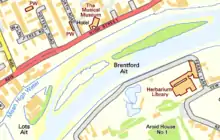
Brentford Ait was also formerly known as Makenshaw, Mattenshaw or Twigg Ait.[3] In the 18th century the ait was inhabited and buildings included a notorious pub called the Swan or Three Swans — its trade was ended in 1796.[3] On the Brentford bank, the Swan Steps lead down to the river at the east end of the long and narrow riverside park, Waterman's Park, at the site of the crossing to this pub. The ait was planted with trees in the 1920s to screen Brentford's gasworks from the view of Kew Gardens. The ait is covered by willows and alder and is a bird sanctuary with a significant heronry. For historic reasons unknown the parish of Kew in Surrey[4] included Brentford in its history; the London Borough of Hounslow administers the neighbouring Lot's Island separated by thick, shifting mud at low tide from Brentford whereas channels on both sides of this Ait are dredged.[5]
See also
References
- OS 25-inch map of 1910 Ordnance Survey London sheet LXXXIV revised 1891-94, published 1897.
- Brentford Quay to Kew Bridge: PLA 306 (PDF) (Map). Port of London Authority. Retrieved 25 July 2017.
- "Site of the Three Swans". Panorama of the Thames. Retrieved 25 July 2017.
- Diane K Bolton; Patricia E C Croot; M A Hicks (1982). T F T Baker; C R Elrington (eds.). "Ealing and Brentford: Introduction". A History of the County of Middlesex: Volume 7: Acton, Chiswick, Ealing and Brentford, West Twyford, Willesden. Institute of Historical Research. Retrieved 21 November 2012.
- Map created by Ordnance Survey, courtesy of English Heritage Archived 24 April 2012 at the Wayback Machine
Bibliography
- Bolton, Diane K; Croot, Patricia E C; Hicks, M A (1982). "Chiswick: Introduction". In Baker, T F T; Elrington, C R (eds.). A History of the County of Middlesex: Volume 7: Acton, Chiswick, Ealing and Brentford, West Twyford, Willesden. Oxford: Oxford University Press for the University of London, Institute of Historical Research. pp. 50–51. OCLC 59178433. Retrieved 5 January 2009.
- Hatts, Leigh (2005). The Thames Path: From the Sea to the Source (2nd ed.). Milnthorpe: Cicerone. ISBN 978-1-85284-436-3. OCLC 276222230.
- Walker, Duncan. "Brentford Ait – Wild, Beautiful & Notorious". Brentford in Literature. Brentford Dock Right Now. Archived from the original on 4 October 2015. Retrieved 26 August 2014.
| Next island upstream | River Thames | Next island downstream |
| Lot's Ait | Brentford Ait | Oliver's Island |
| Wikimedia Commons has media related to Brentford Ait. |
