Bridger, Gallatin County, Montana
Bridger is a census-designated place (CDP) in Gallatin County, Montana, United States. It comprises the Bridger Bowl Ski Area and some nearby residences on the eastern side of the Bridger Range in southwestern Montana. As of the 2010 census the Bridger CDP had a population of 30.[1]
Bridger, Gallatin County, Montana | |
|---|---|
 Bridger  Bridger | |
| Coordinates: 45°49′3″N 110°53′34″W | |
| Country | United States |
| State | Montana |
| County | Gallatin |
| Area | |
| • Total | 3.61 sq mi (9.34 km2) |
| • Land | 3.60 sq mi (9.32 km2) |
| • Water | 0.004 sq mi (0.01 km2) |
| Elevation | 6,040 ft (1,840 m) |
| Population (2010) | |
| • Total | 30 |
| • Density | 3.2/sq mi (1.2/km2) |
| Time zone | UTC-7 (Mountain (MST)) |
| • Summer (DST) | UTC-6 (MDT) |
| Area code(s) | 406 |
| FIPS code | 30-09500 |
| GNIS feature ID | 2583793 |
Montana Highway 86 forms the eastern edge of the CDP, leading north and east 23 miles (37 km) to Wilsall and south and west 16 miles (26 km) to Bozeman. Bridger Creek, a tributary of the Gallatin River, flows southwards through the eastern part of the CDP.
According to the U.S. Census Bureau, the Bridger CDP has a total area of 3.6 square miles (9.3 km2), of which 0.004 square miles (0.01 km2), or 0.16%, is water.[1]
References
- "Geographic Identifiers: 2010 Demographic Profile Data (G001): Bridger CDP, Montana". American Factfinder. U.S. Census Bureau. Retrieved December 21, 2016.
Municipalities and communities of Gallatin County, Montana, United States | ||
|---|---|---|
| Cities | 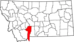 Gallatin County map | |
| Towns | ||
| CDPs | ||
| Other unincorporated communities | ||
| Footnotes | ‡This populated place also has portions in an adjacent county or counties | |
| ||
This article is issued from Wikipedia. The text is licensed under Creative Commons - Attribution - Sharealike. Additional terms may apply for the media files.