Brookings effect
The Chetco effect, also known as the Brookings effect, is a katabatic wind that affects the southern coast of Oregon. Adiabatic heating increases the temperature and reduces relative humidity as winds, driven by high pressure on the Great Basin, descend across the west slopes of the Cascade Range and Oregon Coast Range. It can occur at any time of the year producing temperatures near the Chetco River mouth which are up to 40 °F (22 °C) higher than without the air movement.[1]

On July 8, 2008, Brookings recorded a high temperature of 108 °F (42 °C) at the airport. This was not only the highest recorded temperature in the town's history, but also the highest recorded in Oregon on that day. The Crescent City airport, approximately 30 miles south, recorded a high temperature of 68 °F (20 °C) that day. Temperatures in inland Oregon throughout the Willamette Valley reached temperatures into the mid-nineties. The Brookings Effect remained very strong and localized until July 13, 2008, when high temperatures in Brookings dropped to 61 °F (16 °C), which is about seven degrees lower than average during the month.[1]
The Brookings effect resembles the Santa Ana winds of autumn and winter in Southern California. In nearly every event observed, the Brookings Effect occurs when there is a high pressure ridge off the Pacific Northwest coast or on the Great Basin, depending on the time of year, and often a cutoff low in southern to central California, causing a northerly to easterly wind in the Brookings area.[1]
Studies have shown that the north-to-south orientation of the Chetco River mouth and the town of Brookings plays a large role in the high temperatures recorded, and the reason the effect is localized. During most of the year, a sea breeze sets up along the coastline with prevailing surface winds from the northwest. The heart of Brookings, with its orientation, is protected from this maritime flow and the warm, dry, down-sloping winds that are funneled down the coastal range into the deep Chetco River gorge can reach the coast uninfluenced by the effects of the Pacific.[1][2]
During the Brookings effect, there is a strong correlation between the observed temperature in Brookings and the 850 millibar temperature (the temperature at approximately 5,000 feet (1,500 m)) in Medford, Oregon, as is determined by the radiosonde launched twice daily. Medford, located inland of Brookings, is located in a valley, surrounded by the Oregon Coast Range, the Siskiyou Mountains, and the Cascade Mountains. The surface temperature in Medford is often influenced by the mountains, but the 850 millibar temperature, well off the surface, is about even with the mountain ridges in the area, and therefore unaffected. Mesoscale easterly flow at this level will cause the same air mass to move westward toward Brookings. The Chetco River gorge, which is very deep in some places, works as a funnel to bring the parcel to the coast.[1][2]
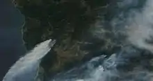
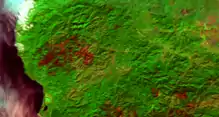
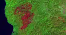
The Brookings effect influences fire behavior in the Kalmiopsis Wilderness and west slope of the southern Oregon Coast Range (see 2017 Chetco Bar Fire and 2002 Biscuit Fire).
Often in the winter, temperatures in Medford may peak near 40 °F (4 °C), while temperatures in Brookings will reach the upper 70s (25+ °C) due to the effect, causing Brookings to live up to its "banana belt" reputation.
References
- Schreiber, Daniel (22 April 2012). "A Study of the Chetco Effect in the City of Brookings, Oregon and Surrounding Areas". Embry-Riddle Aeronautical University.
- Mass, Clifford F. (March 30, 1987). "The "Banana Belt" of the Coastal Regions of Southern Oregon and Northern California". Weather and Forecasting. 2: 253–258. Bibcode:1987WtFor...2..253M. doi:10.1175/1520-0434(1987)002<0253:tbotcr>2.0.co;2.