Brookston, Indiana
Brookston is a town in Prairie Township, White County, in the U.S. state of Indiana.[6] The population was 1,554 as of the 2010 United States Census.
Brookston, Indiana | |
|---|---|
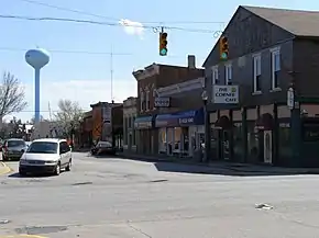 Main Street from State Road 43 | |
| Nickname(s): Star of the Prairie | |
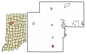 Location of Brookston in White County, Indiana. | |
| Coordinates: 40°36′4″N 86°51′57″W | |
| Country | United States |
| State | Indiana |
| County | White |
| Township | Prairie |
| Area | |
| • Total | 0.66 sq mi (1.7 km2) |
| • Land | 0.66 sq mi (1.7 km2) |
| • Water | 0.00 sq mi (0.0 km2) |
| Elevation | 682 ft (208 m) |
| Population | |
| • Total | 1,554 |
| • Estimate (2019)[4] | 1,533 |
| • Density | 2,323/sq mi (897/km2) |
| Time zone | UTC-5 (EST) |
| • Summer (DST) | UTC-5 (EST) |
| ZIP code | 47923 |
| Area code(s) | 765 |
| FIPS code | 18-08146[5] |
| GNIS feature ID | 431585 |
History
Brookston was platted in 1853, and named for James Brooks, a railroad official.[7]
The Brookston post office has been in operation since the town was platted.[8]
Geography
Brookston is located at 40°36′4″N 86°51′57″W (40.601167, -86.865803).[9]
According to the 2010 census, the town has a total area of 0.66 square miles (1.7 km2), all land.[10]
Demographics
| Historical population | |||
|---|---|---|---|
| Census | Pop. | %± | |
| 1870 | 406 | — | |
| 1880 | 561 | 38.2% | |
| 1890 | 447 | −20.3% | |
| 1900 | 949 | 112.3% | |
| 1910 | 907 | −4.4% | |
| 1920 | 815 | −10.1% | |
| 1930 | 844 | 3.6% | |
| 1940 | 826 | −2.1% | |
| 1950 | 1,014 | 22.8% | |
| 1960 | 1,202 | 18.5% | |
| 1970 | 1,232 | 2.5% | |
| 1980 | 1,701 | 38.1% | |
| 1990 | 1,804 | 6.1% | |
| 2000 | 1,717 | −4.8% | |
| 2010 | 1,554 | −9.5% | |
| 2019 (est.) | 1,533 | [4] | −1.4% |
| US Decennial Census[11] | |||
2010 census
As of the 2010 United States Census,[3] there were 1,554 people, 624 households, and 430 families in the town. The population density was 2,354.5 inhabitants per square mile (909.1/km2). There were 695 housing units at an average density of 1,053.0 per square mile (406.6/km2). The racial makeup of the town was 98.0% White, 0.1% Native American, 0.2% Asian, 0.1% Pacific Islander, 0.5% from other races, and 1.2% from two or more races. Hispanic or Latino of any race were 2.6% of the population.
There were 624 households, of which 34.8% had children under the age of 18 living with them, 50.8% were married couples living together, 11.4% had a female householder with no husband present, 6.7% had a male householder with no wife present, and 31.1% were non-families. 26.1% of all households were made up of individuals, and 11.2% had someone living alone who was 65 years of age or older. The average household size was 2.49 and the average family size was 2.97.
The median age in the town was 37.6 years. 26.6% of residents were under the age of 18; 7% were between the ages of 18 and 24; 26.8% were from 25 to 44; 27.8% were from 45 to 64; and 11.9% were 65 years of age or older. The gender makeup of the town was 46.4% male and 53.6% female.
2000 census
As of the 2000 United States Census,[5] there were 1,717 people, 691 households, and 503 families in the town. The population density was 2,895.8 people per square mile (1,123.6/km2). There were 723 housing units at an average density of 1,219.4 per square mile (473.1/km2). The racial makeup of the town was 98.89% White, 0.06% African American, 0.17% Native American, 0.17% Asian, 0.17% from other races, and 0.52% from two or more races. Hispanic or Latino of any race were 1.46% of the population.
There were 691 households, out of which 36.3% had children under the age of 18 living with them, 55.0% were married couples living together, 13.2% had a female householder with no husband present, and 27.2% were non-families. 23.2% of all households were made up of individuals, and 11.6% had someone living alone who was 65 years of age or older. The average household size was 2.48 and the average family size was 2.91.
The town population contined 28.1% under the age of 18, 6.1% from 18 to 24, 31.0% from 25 to 44, 22.9% from 45 to 64, and 11.8% who were 65 years of age or older. The median age was 36 years. For every 100 females there were 89.7 males. For every 100 females age 18 and over, there were 82.3 males.
The median income for a household in the town was $41,422, and the median income for a family was $47,011. Males had a median income of $35,645 versus $22,891 for females. The per capita income for the town was $18,291. About 4.0% of families and 5.2% of the population were below the poverty line, including 6.1% of those under age 18 and 5.7% of those age 65 or over.
Education
The town has a lending library, the Brookston-Prairie Township Public Library.[12] Frontier Elementary School is a K-6 school. The Jr-Sr High school is located in Chalmers, 2.4 miles (3.8 km) north[13] of Brookston.
Arts and culture
Since 1978 the town has held an annual Brookston Apple Popcorn Festival, on the third Saturday in September. The festival features food and cakes, musical entertainment, contests, races, vendor booths and yard sales.
Brookston is home to Jim Riley, whose agriculture market commentary was featured on the "Hoosier Ag Today" program through 2015.[14]
References
- "2019 US Gazetteer Files". US Census Bureau. Retrieved July 16, 2020.
- "US Board on Geographic Names". United States Geological Survey. 25 October 2007. Retrieved 6 July 2016.
- "US Census website". US Census Bureau. Retrieved 11 December 2012.
- "Population and Housing Unit Estimates". US Census Bureau. May 24, 2020. Retrieved May 27, 2020.
- "US Census website". US Census Bureau. Retrieved 31 January 2008.
- "Brookston, Indiana". Geographic Names Information System. United States Geological Survey. Retrieved 6 July 2016.
- Hamelle, W. H. (1915). A Standard History of White County, Indiana: An Authentic Narrative of the Past, with an Extended Survey of Modern Developments in the Progress of Town and Country. Unigraphic. p. 356.
- "White County". Jim Forte Postal History. Retrieved 6 July 2016.
- "US Gazetteer files: 2010, 2000, and 1990". US Census Bureau. 12 February 2011. Retrieved 23 April 2011.
- "Places: Indiana". 2010 Census Gazetteer Files. US Census Bureau. Archived from the original on 17 May 2014. Retrieved 21 April 2012.
- "Census of Population and Housing". Census.gov. Retrieved June 4, 2015.
- "Indiana public library directory" (PDF). Indiana State Library. Retrieved 15 March 2018.
- Brookston IN (Google Maps, accessed 16 August 2020)
- Jim Riley Market Review, 18 December 2015 (accessed 16 August 2020)
Municipalities and communities of White County, Indiana, United States | ||
|---|---|---|
| City | Map of Indiana highlighting White County | |
| Towns | ||
| Townships | ||
| CDPs | ||
| Other unincorporated communities | ||
| ||
