Browns Summit, North Carolina
Browns Summit (sometimes called Brown Summit) is a small unincorporated community in Guilford County, North Carolina, United States. It is centered just northeast of Greensboro, near the northern end of Summit Avenue, in proximity to Reedy Fork, North Carolina Highway 150, and U.S. Route 29 (which is future Interstate 785) in Guilford County, Latitude 36.212°N & Longitude -79.713°W. The elevation is 801 feet (244 m) above sea level.[1] The single public elementary school is a part of the Guilford County school system. The ZIP Code for Browns Summit is 27214, and it is in the 336 area code.
Browns Summit, North Carolina | |
|---|---|
 Browns Summit  Browns Summit | |
| Coordinates: 36°12′45″N 79°42′49″W | |
| Country | United States |
| State | North Carolina |
| County | Guilford |
| Elevation | 805 ft (245 m) |
| Time zone | UTC-5 (Eastern (EST)) |
| • Summer (DST) | UTC-4 (EDT) |
| ZIP code | 27214 |
| GNIS feature ID | 982041 |
The community still remains rural, consisting of wooded areas and a mixture of open meadows and rolling farmland, however, it is a growing and upcoming area due to the proximity to Greensboro, Burlington, and Reidsville, North Carolina and also for a number of other reasons: recognition of the state's plan to complete Interstate 785 near the area; the new housing developments in progress, particularly along the western area near NC Hwy 150 and Yanceyville Road; the Bryan Park Complex, located at the town's Southern boundary (Bryan Park features the BB&T Soccer complex, Lake Townsend Park (adjacent to the eponymous lake), and the Champions Golf Course), as well as the handful of major factories located in the Bryan Park complex close to the Summit Avenue corridor. Once the Greensboro Urban Loop is completed, the southern reaches of Browns Summit will be in proximity to the loop.
Statistics
Browns Summit (1) "community in north Guilford County. Alt. 805. Land here acquired by Jesse Brown, 1858. Named for him in 1863 when Richmond and Danville Railroad was built, because the Brown farm was the highest point on the line." Powell, p. 66. (2) a post office from 1871 to the present; located in northeast Monroe Township.
See also
References
- http://www.epodunk.com/cgi-bin/genInfo.php?locIndex=274962 Epodunk Community Profile
Municipalities and communities of Guilford County, North Carolina, United States | ||
|---|---|---|
| Cities | 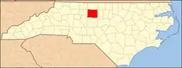 | |
| Towns | ||
| CDPs | ||
| Unincorporated communities | ||
| Footnotes | ‡This populated place also has portions in an adjacent county or counties | |
| ||