Broxburn
Broxburn (Scottish Gaelic: Srath Bhroc, IPA:[ˈs̪ɾaˈvɾɔʰk]) is a town in West Lothian, Scotland located 12 miles (19 km) west of Edinburgh on the A8 road, 5 miles (8.0 km) from Edinburgh Airport and 4.8 miles (7.7 km) to the north of Livingston.
Broxburn
| |
|---|---|
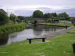 The Union Canal at Broxburn, looking west | |
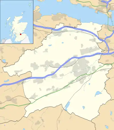 Broxburn Location within West Lothian | |
| Population | 15,440 (mid-2016 est.)[1] |
| OS grid reference | NT081722 |
| Council area | |
| Lieutenancy area | |
| Country | Scotland |
| Sovereign state | United Kingdom |
| Post town | Broxburn |
| Postcode district | EH52 |
| Dialling code | 01506 |
| Police | Scotland |
| Fire | Scottish |
| Ambulance | Scottish |
| UK Parliament | |
| Scottish Parliament | |
Etymology
The name Broxburn is a corruption of "brock's burn", brock being an old Scots name for a badger from the Gaelic broc[2][3] and burn being a Scots word for a large stream or small river.[4] The village was earlier known as Easter Strathbrock (Uphall was Wester Strathbrock)[5] with Strath coming from the Gaelic srath meaning a river valley.
History
The village that later became Broxburn probably originated around 1350 when Margery le Cheyne inherited the eastern half of the Barony of Strathbrock (Easter Strathbrock) on the death of her father, Sir Reginald le Cheyne III. The hamlet that grew up around her residence was then called Eastertoun (eastern town) after the land on which it stood. The lands of Strathbrock were earlier owned by Freskin the Fleming, granted to him under a charter from King David I.
Easter Strathbrock was burned to the ground sometime in 1443-4 during a conflict between William, Earl of Douglas, Lieutenant-General of Scotland, and William, Lord Crichton, Chancellor of Scotland. It was destroyed again in 1455 during fighting between the Douglases and King James II. After the conflict, peace was regained and the town was gradually resettled.
The village was renamed Broxburn in 1600 by Sir Richard Cockburn of Clerkington, Keeper of the Privy Seal of Scotland, almost certainly after Broxburn, East Lothian.
Industry
Past
Broxburn remained an agricultural community until the development of the oil shale industry in the area during the second half of the nineteenth century. This brought in a rapid influx of workers, greatly expanding the local population. Broxburn is still known for its association with the industry, pioneered by the inventor and industrialist James Young. Many shale spoil tips, known as bings, are still in evidence around the town.
Up until its closure in 2013, Hall's of Broxburn employed around 1,700 employees at its meat processing plant to the east of the town.[6] At the time of closure, it was the largest, single employer in Broxburn.
Present
Broxburn now has two separate industrial areas, the Greendykes Industrial Estate and the East Mains Industrial Estate, which provide employment for local people. The largest employers are Campbells Prime Meat Limited, Glenmorangie and Broxburn Bottlers Limited (part of Ian Macleod Distillers Ltd).
Governance
Broxburn lies in the Livingston constituency of the British Parliament and the Almond Valley constituency of the Scottish Parliament.
Before Brexit, it was part of the Scotland European Parliament constituency.
For Local Government purposes, it is part of; the Broxburn, Uphall and Winchburgh Ward of West Lothian Council and is part of West Lothian Council 2nd ward, which also includes the nearby villages of Uphall and Winchburgh
Leisure
The Union Canal passes through Broxburn. It no longer operates as a transport link, but is now used for fishing, magnet fishing and some leisure boating. It has a towpath previously used by the horses which drew canal barges and which is now used as a footpath, the foot paths are popular places for dog walkers, bikers, runners and walkers.
 Union Canal
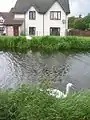
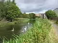 Swans on the canal
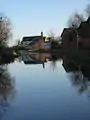 Between Bridges 26 and 27
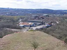
The Shale Bings
The 3 Broxburn Bings (Greendikes Bing, Albion Oil Works Bing and Hopetoun Bing) reside on the north east of Broxburn starting from behind the East Mains Industrial estate. The nearby Niddry Bing resides near the village of Winchburgh. The largest of the three Bings is the Greendykes Bing which when scaled provides excellent views of the whole area. The Bings were created by large piles of spoil from the shale mines being dumped on top of each over to form the Bings.
Notable residents
- Anthony Stokes (Professional Footballer)
- James Anderson (swimmer) (Paralympian)
- Charles Benham (cricketer)
- Mark Burchill (footballer)
- Steven Craig (footballer)
- Bill Bann (footballer)
- James Baird (footballer)
- Colin Fleming, tennis player
- Gavin Hamilton (cricketer)
- John Kerr (figure skater)
- Shelley Kerr, football manager
- Stephen Robson, Bishop
- Liam Henderson,(footballer)
- Alexander Steuart clock and instrument-maker
Education
Broxburn has four schools, all state-funded, Broxburn Primary, Kirkhill Primary, St. Nicholas Roman Catholic Primary and Broxburn Academy.
Sports and health
Broxburn is home to the football club Broxburn Athletic, who play in the East of Scotland League. There are sports and health facilities publicly available, including a sports centre, library, swimming pool and bowling clubs. A motorcycle dirt track was built at The Sports Park in 1928 and a few demonstration events were staged to show off the new sport to football fans. Due to Broxburn's proximity to Edinburgh it was not licensed. Another demonstration event at motorcycle club event in 1929 ended after both riders crashed.
Transport
Broxburn has regular links to Edinburgh, Livingston, Linlithgow and Edinburgh Airport. Operators serving the town include, First, Lothian Country & E&M Horsburgh. The nearest railway station is at Uphall providing links to Edinburgh, Livingston, Bathgate, Airdrie and Glasgow.
Hospitals
The local hospital is St. John's Hospital at Howden in Livingston. Broxburn has its own health centre at the Strathbrock Partnership Centre.
Churches
Broxburn has six churches;
- New Life Christian Fellowship Broxburn in Strathbrock Community Centre,
- Broxburn Baptist Church,
- Broxburn Catholic Church,
- Broxburn Parish Church,
- Grace Community Church,
- St Nicholas United Free Church of Scotland.
There are also some other religious groups active in the town, including Jehovah's Witnesses and several evangelical Christian organisations.
Bibliography
- Canule, Canule, Birnin Bricht— by David Kerr, 2005
- Discovering West Lothian by William F. Hendrie, John Donald Publishers Ltd, Edinburgh, 1986
- A History of Broxburn by Peter Caldwell
- Strathbrock Area Guide prepared and published by Uphall Community Council with assistance from Broxburn Community Council and Ecclesmachan & Threemiletown Community Council
References
- "Mid-2016 Population Estimates for Settlements and Localities in Scotland". National Records of Scotland. 12 March 2018. Retrieved 30 December 2020.
- https://www.etymonline.com/word/brock
- https://dwelly.info/ViewEntry.aspx?ID=7A7AE38FB37C8F842E27AB4F25987983
- "Burn". Dictionary of the Scots Language. Retrieved 30 August 2020.
- Taylor, Iain (2011). Place-names of Scotland. Edinburgh: Birlinn Ltd.
- "Production ends at Hall's plant". BBC News. 6 February 2013. Retrieved 21 May 2020.
External links
| Wikimedia Commons has media related to Broxburn, West Lothian. |
- Broxburn and Uphall Community Website
- Sure Start Local Information on Broxburn
- Broxburn Community Council
- Broxburn & Uphall Traders' Association
- West Lothian Council
- National Library of Scotland: SCOTTISH SCREEN ARCHIVE (archive films about Broxburn)
- SS John Cantius and Nicholas
- Orange Order in Broxburn
- Broxburn Football Story
| Authority control |
|
|---|