Buckautal
Buckautal is a municipality in the Potsdam-Mittelmark district, in Brandenburg, Germany.
Buckautal | |
|---|---|
Location of Buckautal within Potsdam-Mittelmark district 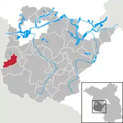 | |
 Buckautal  Buckautal | |
| Coordinates: 52°13′59″N 12°19′19″E | |
| Country | Germany |
| State | Brandenburg |
| District | Potsdam-Mittelmark |
| Municipal assoc. | Ziesar |
| Subdivisions | 4 Ortsteile |
| Government | |
| • Mayor | Mike Pokorny |
| Area | |
| • Total | 39.07 km2 (15.09 sq mi) |
| Elevation | 70 m (230 ft) |
| Population (2019-12-31)[1] | |
| • Total | 487 |
| • Density | 12/km2 (32/sq mi) |
| Time zone | UTC+01:00 (CET) |
| • Summer (DST) | UTC+02:00 (CEST) |
| Postal codes | 14793 |
| Dialling codes | 033830 |
| Vehicle registration | PM |
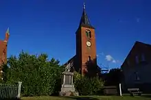
The Church
Demography

Development of Population since 1875 within the Current Boundaries (Blue Line: Population; Dotted Line: Comparison to Population Development of Brandenburg state; Grey Background: Time of Nazi rule; Red Background: Time of Communist rule)
|
|
References
- "Bevölkerung im Land Brandenburg nach amtsfreien Gemeinden, Ämtern und Gemeinden 31. Dezember 2019". Amt für Statistik Berlin-Brandenburg (in German). July 2020.
- Detailed data sources are to be found in the Wikimedia Commons.Population Projection Brandenburg at Wikimedia Commons
Towns and municipalities in Potsdam-Mittelmark | ||
|---|---|---|
| Coat of Arms of Potsdam-Mittelmark district | |
This article is issued from Wikipedia. The text is licensed under Creative Commons - Attribution - Sharealike. Additional terms may apply for the media files.