Buford Township, Union County, North Carolina
Buford Township, population 10,323, is one of nine townships in Union County, North Carolina. Buford Township is 98.95 square miles (256.3 km2)[1] in size and is located in south-central Union County. The Town of Mineral Springs, North Carolina barely covers the northwest of corner of the township.
Buford Township, Union County, North Carolina | |
|---|---|
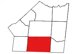 Location of Buford Township in Union County | |
 Location of Union County in North Carolina | |
| Country | United States |
| State | North Carolina |
| County | Union |
| Area | |
| • Total | 98.95 sq mi (256.28 km2) |
| Highest elevation [2] (northeast quarter of township) | 748 ft (228 m) |
| Lowest elevation | 478 ft (146 m) |
| Population (2010) | |
| • Total | 10,323[3] |
| • Density | 104.32/sq mi (40.28/km2) |
| Time zone | UTC-4 (EST) |
| • Summer (DST) | UTC-5 (EDT) |
| Area code(s) | 704 |
Geography
The northside of the township is drained by tributaries to Richardson Creek including Adams Branch, Beaverdam Creek, Little Richardson Creek, and Rays Fork. The east side of the township is drained by Lanes Creek and its tributaries, Wicker Branch and Mill Creek. The southside of the township is drained by the Lynches River and its tributaries Buffalo Creek and Polecat Creek. The southwest side is drained by Cane Creek. The west side is drained by Glen Branch of Waxhaw Creek.[4]
References
- "NC OneMap". www.nconemap.gov. State of North Carolina. Retrieved 13 September 2020.
- "The National Map - Service Endpoints". viewer.nationalmap.gov. US Geological Survey. Retrieved 13 September 2020.
- "US Census Bureau Populations". data.census.gov. US Census Bureau. Retrieved 14 October 2020.
- "North Carolina Flood Hazard Area Effective". www.nconemap.gov. State of North Carolina. Retrieved 16 October 2020.
Municipalities and communities of Union County, North Carolina, United States | ||
|---|---|---|
| City | 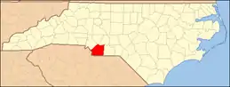 | |
| Towns | ||
| Villages | ||
| CDP | ||
| Unincorporated communities | ||
| Ghost town | ||
| Footnotes | ‡This populated place also has portions in an adjacent county or counties | |
| ||