Bukama
Bukama is a town in Haut-Lomami Province of south-eastern Democratic Republic of the Congo. As of 2009 it had an estimated population of 42,718.[2]
Bukama | |
|---|---|
 Bukama Location in the Democratic Republic of the Congo | |
| Coordinates: 9°12′S 25°50′E | |
| Country | |
| Province | Haut-Lomami |
| Elevation | 1,499 m (4,918 ft) |
| Population (2009) | |
| • Total | 42,718 |
| Time zone | UTC+2 (Lubumbashi Time) |
| Climate | Aw |
Climate
Köppen-Geiger climate classification system classifies its climate as a tropical savanna climate (Aw).[1]
| Climate data for Bukama | |||||||||||||
|---|---|---|---|---|---|---|---|---|---|---|---|---|---|
| Month | Jan | Feb | Mar | Apr | May | Jun | Jul | Aug | Sep | Oct | Nov | Dec | Year |
| Average high °C (°F) | 29.8 (85.6) |
29.9 (85.8) |
30.7 (87.3) |
31.1 (88.0) |
31.8 (89.2) |
30.6 (87.1) |
31.3 (88.3) |
32.6 (90.7) |
34.0 (93.2) |
32.8 (91.0) |
31.5 (88.7) |
29.9 (85.8) |
31.3 (88.4) |
| Daily mean °C (°F) | 24.8 (76.6) |
24.9 (76.8) |
25.5 (77.9) |
25.5 (77.9) |
24.6 (76.3) |
22.6 (72.7) |
22.8 (73.0) |
24.3 (75.7) |
26.2 (79.2) |
26.2 (79.2) |
25.9 (78.6) |
24.9 (76.8) |
24.8 (76.7) |
| Average low °C (°F) | 19.9 (67.8) |
20.0 (68.0) |
20.4 (68.7) |
20.0 (68.0) |
17.5 (63.5) |
14.6 (58.3) |
14.4 (57.9) |
16.1 (61.0) |
18.4 (65.1) |
19.6 (67.3) |
20.3 (68.5) |
20.0 (68.0) |
18.4 (65.2) |
| Average precipitation mm (inches) | 95 (3.7) |
77 (3.0) |
86 (3.4) |
39 (1.5) |
4 (0.2) |
0 (0) |
0 (0) |
2 (0.1) |
9 (0.4) |
34 (1.3) |
71 (2.8) |
88 (3.5) |
505 (19.9) |
| Source: Climate-Data.org, altitude: 1499m[1] | |||||||||||||
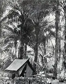
Commandant Léon Tonneau (1863-1919) camp, in his inspection round in Bukama (Katanga) between 1903 et 1906. Tonneau was director of the "Comité Spécial du Katanga."
References
- "Climate: Bukama - Climate graph, Temperature graph, Climate table". Climate-Data.org. Retrieved 17 September 2013.
- "Congo (Dem. Rep.): largest cities and towns and statistics of their population". World Gazetteer. Archived from the original on May 22, 2011. Retrieved January 21, 2009.
This article is issued from Wikipedia. The text is licensed under Creative Commons - Attribution - Sharealike. Additional terms may apply for the media files.