Provinces of the Democratic Republic of the Congo
There are currently twenty-five provinces in the Democratic Republic of the Congo.[1] The capital, Kinshasa city, is administratively equivalent to a province.[2][3]
| Provinces of the Democratic Republic of the Congo Provinces de la République démocratique du Congo (French) | |
|---|---|
| Also known as: Mikoa ya Jamhuri ya Kidemokrasia ya Kongo (Swahili) Bitúká bya Kongó-Kinsásá (Lingala) | |
 | |
| Category | Unitary State |
| Location | Democratic Republic of the Congo |
| Number | 26 provinces (1 is a city-province) |
| Populations | 1,138,000 (Bas-Uele) – 11,575,000 (Kinshasa) |
| Areas | 9,481 km2 (3,661 sq mi) (Kasaï-Oriental) – 199,567 km2 (77,053 sq mi) (Tshopo) |
| Government | Provincial government |
| Subdivisions | Territory |
 |
|---|
| This article is part of a series on the politics and government of the Democratic Republic of the Congo |
| United Nations Mission |
|
|
List
History
When Belgium annexed the Belgian Congo as a colony in November 1908, it was initially organised into 22 districts. Ten western districts were administered directly by the main colonial government, while the eastern part of the colony was administered under two vice-governments: eight northeastern districts formed Orientale Province, and four southeastern districts formed Katanga. In 1919, the colony was organised into four provinces:
- Congo-Kasaï (five southwestern districts),
- Équateur (five northwestern districts),
- Orientale Province and Katanga (previous vice-governments).[2]
In 1932, the colony was reorganised into six provinces. Initially they were named after their capital cities, but in 1947 regional names were adopted.[2]
The Belgian Congo became an independent country in 1960, named Republic of the Congo. By 1963, the country was organised into 21 provinces (informally called provincettes) plus the capital city of Léopoldville, similar to the original 22 districts under colonial rule. In 1966, the 21 provincettes were grouped into eight provinces, and the capital city was renamed Kinshasa.[2]
In 1971, the country was renamed Zaire, and three provinces were also renamed. In 1975, the capital city of Kinshasa obtained the status of a province. In 1988, the province of Kivu was split into three. In 1997, the country was renamed Democratic Republic of the Congo, and the three provinces that had been renamed in 1971 either retook their previous name or took another.[2]
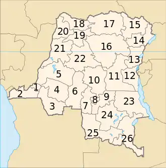
Article 2 of the Constitution of the Democratic Republic of the Congo, adopted in 2006, specifies a territorial organisation into 26 provinces,[4] again resembling the previous provincettes and original colonial districts. The reorganisation was scheduled to take effect within three years of the new constitution's promulgation, however progress was slow.[5] In October 2007 the Minister for Decentralisation, Denis Kalume Numbi, presented a bill for decentralisation in the National Assembly. The subsequent debate turned up a variety of issues that first had to be addressed with changes to related laws.[6] In an October 2010 conclave of the ruling AMP coalition, it was proposed to revise Article 226, which calls for the creation of 26 provinces out of the current 11, in order to allow more time for the transition.[7] On 9 January 2015 the National Assembly passed a law on the new administrative divisions of the country, according to which new provinces should be installed in period of 12 months.[8][9]
Maps
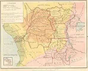 Districts of the Belgian Congo in 1914
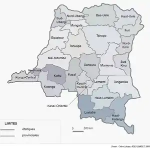
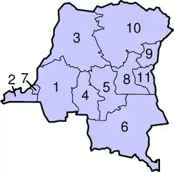 Provinces of the Democratic Republic of the Congo, 1997–2015
- Provinces since 2015 (officially formed in 2006)
Approximate correspondence between historical and current provinces
| Belgian Congo | First Republic | Second Republic (Zaire) | Third Republic | ||||||
|---|---|---|---|---|---|---|---|---|---|
| 1908 | 1919 | 1932 | 1947 | 1963 | 1966 | 1971 | 1988 | 1997 | 2015 |
| 22 districts | 4 provinces | 6 provinces | 6 provinces | 21 provinces + capital | 8 provinces + capital | 8 regions + capital | 11 regions | 11 provinces | 26 provinces |
| Tanganika-Moero | Katanga | Élisabethville | Katanga | Nord-Katanga | Katanga | Shaba | Katanga | Tanganyika | |
| Haut-Lomami | |||||||||
| Lulua | Lualaba | Lualaba | |||||||
| Haut-Luapula | Katanga-Oriental | Haut-Katanga | |||||||
| Lomami | Lusambo | Kasaï | Lomami | Kasaï-Oriental | Lomami | ||||
| Sankuru | Congo-Kasaï | Sankuru | Sankuru | ||||||
| Kasaï | Sud-Kasaï | Kasaï-Oriental | |||||||
| Luluabourg | Kasaï-Occidental | Kasaï-Central | |||||||
| Unité-Kasaïenne | Kasaï | ||||||||
| Moyen-Congo | Léopoldville | Léopoldville | Kinshasa | ||||||
| Bas-Congo | Congo-Central | Bas-Zaïre | Bas-Congo | Kongo Central | |||||
| Kwango | Kwango | Bandundu | Kwango | ||||||
| Kwilu | Kwilu | ||||||||
| Lac Léopold II | Équateur | Mai-Ndombe | Mai-Ndombe | ||||||
| Équateur | Coquilhatville | Équateur | Cuvette-Centrale | Équateur | Équateur | ||||
| Tshuapa | |||||||||
| Lulonga | Moyen-Congo | Mongala | |||||||
| Bangala | |||||||||
| Ubangi | Ubangi | Nord-Ubangi | |||||||
| Sud-Ubangi | |||||||||
| Bas-Uele | Orientale | Stanleyville | Orientale | Uele | Orientale | Haut-Zaïre | Orientale | Bas-Uele | |
| Haut-Uele | Haut-Uele | ||||||||
| Ituri | Kibali-Ituri | Ituri | |||||||
| Stanleyville | Haut-Congo | Tshopo | |||||||
| Aruwimi | |||||||||
| Maniema | Costermansville | Kivu | Maniema | Kivu | Maniema | ||||
| Lowa | |||||||||
| Kivu | Nord-Kivu | Nord-Kivu | |||||||
| Kivu-Central | Sud-Kivu | ||||||||
See also
- History of the administrative divisions of the Democratic Republic of the Congo (in French)
- List of provincial governors of the Democratic Republic of the Congo
- Lists of provincial governors of the Democratic Republic of the Congo
- List of provinces of the Democratic Republic of Congo by Human Development Index
- Districts of the Democratic Republic of the Congo
- Districts of the Belgian Congo
- Territories of the Democratic Republic of the Congo
- ISO 3166-2:CD
References
- "The World Factbook". www.cia.gov. Central Intelligence Agency. Retrieved 10 May 2016.
- Provinces of the Democratic Republic of Congo, Statoids, accessed 1 May 2016.
- Nouvelles entités provinciales Archived 2011-07-23 at the Wayback Machine, Joseph M. Kyalangilwa, 22 January 2007.
- Constitution of the Democratic Republic of the Congo, article 2, Wikisource. (in French)
- "Provinces of the Democratic Republic of Congo (Congo Kinshasa)". Statoids. Retrieved 2011-11-22.
- "La décentralisation dans l'impasse". Le Potentiel. 23 October 2007. Retrieved 2011-11-21.
- JASON STEARNS (October 12, 2010). "The AMP conclave: Another step towards 2011 elections". Retrieved 2011-11-23.
- The National Assembly adopts the laws regarding the limits of the provinces in the Democratic Republic of the Congo, National Assembly of the Democratic Republic of the Congo, 10 January 2015. (in French)
- Election of governors: definite results expected on 18 April, Radio Okapi, 27 March 2016. (in French)
Bibliography
- Gwillim Law (1999). "Democratic Republic of the Congo". Administrative Subdivisions of Countries: A Comprehensive World Reference, 1900 through 1998. US: McFarland & Company. pp. 92–94. ISBN 0786407298.
- Jean-Claude Bruneau (2009). "Les nouvelles provinces de la République Démocratique du Congo: construction territoriale et ethnicités". L'Espace politique (in French). 7 (7). doi:10.4000/espacepolitique.1296 – via Revues.org.CS1 maint: multiple names: authors list (link)
