Bulwick
Bulwick is a village and civil parish in the East Northamptonshire district of Northamptonshire, England. According to the 2001 census it had a population of 152 people,[1] including Blatherwycke and increasing to 171 at the 2011 census.[2] It is about six miles north-east of Corby, and is just off the A43 road. The Willow Brook runs through the village.
| Bulwick | |
|---|---|
 The Queen's Head | |
 Bulwick Location within Northamptonshire | |
| Population | 171 (2011) |
| OS grid reference | SP9594 |
| District | |
| Shire county | |
| Region | |
| Country | England |
| Sovereign state | United Kingdom |
| Post town | Corby |
| Postcode district | NN17 |
| Dialling code | 01780 |
| Police | Northamptonshire |
| Fire | Northamptonshire |
| Ambulance | East Midlands |
| UK Parliament | |
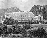
Bulwick Park, home of the Tryon family
The village Church of England parish church is dedicated to St Nicholas. Bulwick Meadows is a Site of Special Scientific Interest.
The village is twinned with Adams, North Dakota.
References
- Office for National Statistics: Bulwick CP: Parish headcounts. Retrieved 7 November 2009
- "Civil Parish population 2011". Neighbourhood Statistics. Office for National Statistics. Retrieved 29 June 2016.
This article is issued from Wikipedia. The text is licensed under Creative Commons - Attribution - Sharealike. Additional terms may apply for the media files.