Bungotakada, Ōita
Bungotakada (豊後高田市, Bungotakada-shi) is a city located in Ōita Prefecture, Kyushu, Japan.
Bungotakada
豊後高田市 | |||||||||||
|---|---|---|---|---|---|---|---|---|---|---|---|
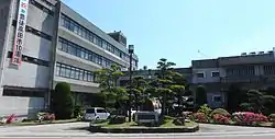 Bungotakada city hall | |||||||||||
 Flag  Emblem | |||||||||||
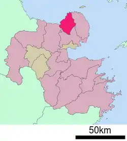 Location of Bungotakada in Ōita Prefecture | |||||||||||
 Bungotakada Location in Japan | |||||||||||
| Coordinates: 33°33′N 131°27′E | |||||||||||
| Country | Japan | ||||||||||
| Region | Kyushu | ||||||||||
| Prefecture | Ōita Prefecture | ||||||||||
| Government | |||||||||||
| • Mayor | Katsuji Shutō (since April 2009) | ||||||||||
| Area | |||||||||||
| • Total | 206.65 km2 (79.79 sq mi) | ||||||||||
| Population (March 31, 2017) | |||||||||||
| • Total | 23,059 | ||||||||||
| • Density | 110/km2 (290/sq mi) | ||||||||||
| Time zone | UTC+09:00 (JST) | ||||||||||
| City hall address | 1650 Ōji-Aiai, Bungotakada-shi, Ōita-ken 878-8555 | ||||||||||
| Website | www | ||||||||||
| |||||||||||
As of March 31, 2017, the city has an estimated population of 23,059, with 10,595 households and a population density of 110 persons per km².[1] The total area is 206.65 km².
On March 31, 2005, the towns of Kakaji and Matama (both from Nishikunisaki District) were merged into Bungotakada.
Agriculture
Bungotakada is known for negi (Welsh onions).
Points of interest
Historic sites include Fuki-ji, Maki Ōdō, and Kumano magaibutsu.
Shōwa Town (Shōwa no Machi in Japanese) is also a sightseeing spot.
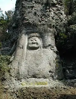 Fudō-Myoō Stature in Kumano Magaibutsu |
 Shōwa Style Town Visitor Attraction (Shōwa no Machi in Japanese) in Bungotakada. |
References
- "Official website of Bungotakada city" (in Japanese). Japan: Bungotakada City. Retrieved 21 April 2017.
External links
| Wikimedia Commons has media related to Bungotakada, Ōita. |
- Bungotakada City official website (in Japanese)
| Authority control |
|---|
This article is issued from Wikipedia. The text is licensed under Creative Commons - Attribution - Sharealike. Additional terms may apply for the media files.