Burzil Pass
The Burzil Pass (el. 4,100 m (13,500 ft))[3] is an ancient pass in northern Pakistan, and is part of the historic caravan route between Srinagar and Gilgit. The pass lies approximately 5 km north of the administrative line between Pakistani-administered Gilgit-Baltistan and Azad Jammu and Kashmir, and some 30 km north of the Line of Control (LoC), which serves as the de facto border between India and Pakistan in Kashmir. Pakistan has closed off some of the major sections of the Burzil route (which used to run freely through undivided Kashmir) due to the fact that the region is now a conflict territory and partitioned. The crest of the pass is wide and covered with lush alpine grass vegetation during the summertime. The Astor River originates from the western slopes of the pass.[4]
| Burzil Pass | |
|---|---|
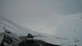 Part of the route through the Burzil Pass in Pakistani-administered Kashmir | |
| Elevation | 4,100 m (13,451 ft)[1] |
| Length | 46 miles (74 km) |
| Location | Gilgit-Baltistan, Pakistan |
| Range | Himalayas |
| Coordinates | 34°54′00″N 75°06′00″E[2] |
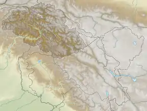 Location in Gilgit-Baltistan | |
It is the oldest-known route connecting Gilgit with Srinagar and Skardu through the Deosai Plateau. Ancient travellers are believed to have extensively crossed the pass by horse. At the beginning of the 20th century, a hut was situated on the crest of the pass, where post couriers delivered mail and messages from India to China.[5]
The city of Gilgit is some 367 km (228 mi)[3] from Srinagar by road via the Burzil Pass above the northern banks of Wular Lake and Gurez in Jammu and Kashmir.[6]
The route from Astore to and through the Burzil Pass passes through the following key points: Gorikot, Astore River Bridge, Maikaal, Dad Khitran, and Chilam Chowki.
Popular Culture
- The explorer William Douglas Burden described crossing the pass in the chapter "Savage Abadabur" of his book, Look to the Wilderness.[7]
References
- "Burzil Pass, a hairpinned climb in Pakistan". www.dangerousroads.org. Retrieved 2020-09-10.
- GeoNames.org. "Burzil Pass".
- Imperial Gazetteer of India. Provincial Series: Kashmir and Jammu (facsimile reprint). Adamant Media Corporation (original: Superintendent of Government Printing, Calcutta). 4 July 2001 [1909]. p. 8. ISBN 978-0-543-91776-8. Retrieved 2009-08-10.
- Sultana, K.; Muqarrab Shah; T.M.Upson (2007). "Altitudinal Distribution of Grasses, Sedges and Rushes of Deosai Plateau: Pakistan". The Electronic Journal of Environmental, Agricultural and Food Chemistry. 6 (11): 2518. ISSN 1579-4377. Archived from the original on 2009-12-18. Retrieved 2009-08-11.
- "The Western Regions according to the Hou Hanshu, Chapter on the Western Regions from Hou Hanshu 88, The Kingdom of Wuyishanli 烏弋山離 (Kandahar, including Arachosia and Drangiana), 2nd ed". John Hill (translation, notes, appendices). September 2003.CS1 maint: others (link)
- Bamzai, P. N. K. (1994). Culture and political history of Kashmir. 1. Ancient Kashmir. M D Publications. p. 9. ISBN 978-81-85880-31-0. Retrieved 2009-08-10.
- Burden, W. Douglas (1956). Look to the Wilderness. Boston: Little, Brown and Company. pp. 145–165.
