Buzi River (Mozambique)
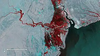
Buzi River (Portuguese: Rio Búzi) is a river in Mozambique. The Buzi River originates in the Eastern Highlands (or Manica Highlands) on the border of Mozambique and Zimbabwe, and flows eastward through Manica and Sofala provinces of Mozambique. It empties to the Mozambique Channel west of Beira, forming a large estuary with the Pungwe River.
The Buzi River is 250 kilometres (155 mi) long, with a drainage basin 31,000 square kilometres (12,000 sq mi) in size. Its mean annual discharge is 79 m³/s (2,790 cfs) at its mouth.[1]
It often causes floods, frequently forming a floodplain together with the larger Pungwe River. Dombé and Búzi are situated on the banks of the river.
The Buzi and its principal tributaries rise in the Eastern Highlands, or Manica Highlands, along the border with Zimbabwe. Some of the Buzi's headwater streams rise in Zimbabwe, and in other places the international border follows the watershed boundary.
The Revué river is the main northern tributary, and its headwaters are in the Eastern Highlands near Machipanda. In 1968, Mozambique's colonial government built the hydroelectric Chicamba Dam across the Revué to create Lake Chicamba.[2]
The Lucite River, known upstream in Zimbabwe as the Rusitu or Lusitu, is the central tributary, joining the Buzi above the Revué.
The Mossurize River joins the Buzi from the southwest, above the Lucite.
The Save River watershed lies west and southwest of the Buzi watershed. The Pungwe watershed lies to the north.
Notes
- Nakayama, Mikiyasu (2003). International Waters in Southern Africa. United Nations University Press. p. 9. ISBN 92-808-1077-4.; online at Google Books
- Briggs, Philip (2011)Mozambique. Brandt Travel Guides, 2011. p. 217