Cère
The Cère is a 120.4 km (75 mi) long river in south-western France, left tributary of the Dordogne.[1] Its source is in the south-western Massif Central, near the mountain Plomb du Cantal. It flows generally west through the following départements and towns:
- Cantal: Vic-sur-Cère, Arpajon-sur-Cère (near Aurillac)
- Corrèze
- Lot: Bretenoux
| Cère | |
|---|---|
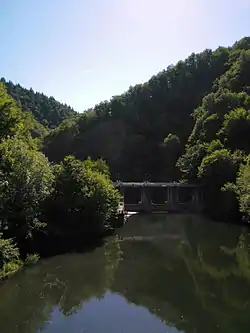 Cère gorge near Lamativie, where it forms the Corrèze/Lot border, showing hydroelectric barrage. | |
.png.webp) | |
| Location | |
| Country | France |
| Physical characteristics | |
| Source | |
| • location | Massif Central |
| Mouth | |
• location | Dordogne |
• coordinates | 44°54′33″N 1°48′45″E |
| Length | 120 km (75 mi) |
| Basin features | |
| Progression | Dordogne→ Gironde estuary→ Atlantic Ocean |
The Cère flows into the Dordogne River near Bretenoux.
References
This article is issued from Wikipedia. The text is licensed under Creative Commons - Attribution - Sharealike. Additional terms may apply for the media files.
