CFB Chatham
Canadian Forces Base Chatham or CFB Chatham was a Canadian Forces Base located immediately south of the town of Chatham, New Brunswick, Canada. Parts are now operating as Miramichi Municipal Airport since 1974 with a partial runway available (09/27 - asphalt).
| CFB Chatham | |||||||||||
|---|---|---|---|---|---|---|---|---|---|---|---|
| Near Chatham, New Brunswick in Canada | |||||||||||
 CFB Chatham crest | |||||||||||
 CFB Chatham | |||||||||||
| Coordinates | 47°0′49.32″N 65°26′49.56″W | ||||||||||
| Site information | |||||||||||
| Owner | Dept of National Defence (Canada) | ||||||||||
| Airfield information | |||||||||||
| Elevation | 90 ft (27 m) AMSL | ||||||||||
| |||||||||||
| Airfields | |||||||||||

Base Rescue CH-118 Iroquois helicopters, 1982
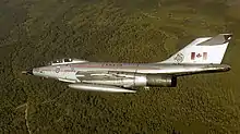
CF101B Voodoo of 416 (AWF) Squadron from CFB Chatham, NB, 1980
From 1970 until 1985 Chatham had a Base Rescue Flight operating three CH-118 Iroquois helicopters. When the CF-101 Voodoo interceptors were retired, the CH-118s were redeployed to Base Flight Cold Lake.[1]
Aerodrome Information
In approximately 1942 the aerodrome was listed at 47°01′N 65°27′W with a Var. 24 degrees 30' W and elevation of 90 feet (27 m). Three runways were listed as follows:[2]
| Runway Name | Length | Width | Surface |
|---|---|---|---|
| 11/29 | 5,000 ft (1,500 m) | 150 ft (46 m) | Hard surfaced |
| 16/34 | 5,000 ft (1,500 m) | 150 ft (46 m) | Hard surfaced |
| 5/23 | 5,000 ft (1,500 m) | 150 ft (46 m) | Hard surfaced |
Squadrons
- 1942 No. 113 (Bomber-Reconnaissance) Squadron - Lockheed Hudson
- 1943 No. 119 (Bomber-Reconnaissance) Squadron - Lockheed Hudson
- 1941-1942 No. 21 Elementary Flying Training School[3]
- 1941-1945 No. 10 Air Observer School[4]
- 1949-1950s - airbase with Canadair Sabre and de Havilland Vampire
- 1949-1951 No. 421 Squadron RCAF
- late 1950-1960s Golden Hawks - Canadair Sabres
- 1962-1984 No. 416 Squadron RCAF - McDonnell CF-101 Voodoo and Base Rescue Flight - CH-118 Iroquois
- 1984-1989 No. 434 Squadron RCAF - Canadair CF-5 and Base Rescue Flight - CH-118 Iroquois
References
- AEROWARE / RCAF.com (n.d.). "Bell CH-118 IROQUOIS". Archived from the original on 2008-01-06. Retrieved 2007-10-24.
- Staff writer (c. 1942). Pilots Handbook of Aerodromes and Seaplane Bases Vol. 1. Royal Canadian Air Force. p. 43.
- Military Bruce Historical Writings by Bruce Forsyth
- Hatch, F. J. (1983).The Aerodrome of Democracy: Canada and the British Commonwealth Air Training Plan, 1939-1945. Ottawa: Directorate of History, Department of National Defence. ISBN 0660114437
External links
| Wings | |
|---|---|
| Squadrons | |
| |
| |
|
| Squadron numbers |
| ||||||||||||||||||||||
|---|---|---|---|---|---|---|---|---|---|---|---|---|---|---|---|---|---|---|---|---|---|---|---|
| Squadron codes |
| ||||||||||||||||||||||
1 Aircraft administered and serviced by the RCAF but manned by the Royal Canadian Artillery.
2 Non-standard code as unit using OW added L. Letters normally denoted parent Command, aircraft type (L Liberator transport, D Dakota etc), unit, and individual aircraft. 3 VC 4 XX | |||||||||||||||||||||||
| Military history | |
|---|---|
| Leadership | |
| Commands | |
| Academies | |
| |
This article is issued from Wikipedia. The text is licensed under Creative Commons - Attribution - Sharealike. Additional terms may apply for the media files.