Cabo de Santo Agostinho
Cabo de Santo Agostinho (Cape of Saint Augustine) is 35 km south of the city of Recife, Pernambuco, Brazil. Although the official Portuguese discovery of Brazil was by Pedro Álvares Cabral on April 21, 1500, some historians believe that Vicente Yáñez Pinzón already had set anchor in a bay in Cabo de Santo Agostinho on January 26, 1500, which he named Cabo de Santa María de la Consolación.[3] It was incorporated as a town in 1811.
Cabo de Santo Agostinho
Municipality of Cabo de Santo Agostinho | |
|---|---|
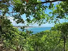
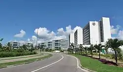 View of Cabo de Santo Agostinho | |
 Flag  Seal | |
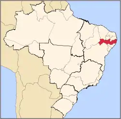
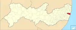 Location in the state of Pernambuco and Brazil | |
 Cabo de Santo Agostinho Location in Brazil | |
| Coordinates: 8°17′23″S 35°1′48″W | |
| Country | Brazil |
| Area | |
| • Total | 445.343 km2 (171.948 sq mi) |
| Elevation | 29 m (95 ft) |
| Population (2020 [2]) | |
| • Total | 208,944 |
| • Density | 470/km2 (1,200/sq mi) |
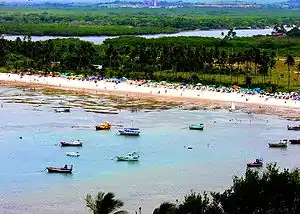
Cabo de Santo Agostinho has both an industrial section that is centered on the Suape port and many tropical beaches and nature reserves. The best known beaches are Calhetas, Paraíso, and Gaibu. Recanto do Domingos lies at the far south end of Pedra do Xareu beach.
Geography
- State: Pernambuco
- Region: RMR (Recife)
- Boundaries: Jaboatão dos Guararapes, Moreno, Pernambuco (N), Ipojuca, Escada (S), Vitória de Santo Antão (W) and Atlantic ocean (E)
- Area: 447.88 km2
- Elevation: 29 m
- Hydrography: small coast rivers
- Beaches: Gaibu, Enseada dos corais, Calhetas, Paraiso and Pedra do Xareu
- Vegetation: Atlantic forest, Capoeirinha, Coconut trees, sugarcane plantation and Manguezais
- Clima: Hot tropical and humid
- Annual average temperature: 25.2° C
- Main road: BR 101
- Distance to Recife: 35 km
Economy
The main economic activities in Cabo de Santo Agostinho are tourism, commerce and a strong and diverse general industry sector located near the Suape port.
Economic indicators
| Population [4] | GDP x(1000 R$).[5] | GDP pc (R$) | PE | RMR |
|---|---|---|---|---|
| 171.583 | 2.813.188 | 17.244 | 4.60% | 7.16% |
| Primary sector | Secondary sector | Service sector |
|---|---|---|
| 0.57% | 59.94% | 39.49% |
Suape Harbour
Suape port is an international port located in the city of Ipojuca in the state of Pernambuco, between the municipalities of Ipojuca and Cabo de Santo Agostinho, within the Recife metropolitan area and distant 40 km south of the capital (Recife). Suape serves ships 365 days a year without any restriction with regard to tidal schedules. Suape is one of the most important harbour and container terminals in northeast Brazil playing an important role in the economy of the state of Pernambuco.[6] In the 21st century, Suape has become the main driving force behind the economic development of Pernambuco. Its logistic advantages have attracted national and international investment on a huge scale, with over US$10 billion expected by 2010.
Beaches
- Paiva beach
- A favored destination for those wishing to practice surfing surf, Paiva beach has warm, crystal clear waters, Atlantic forest vegetation and coconut trees, and small natural pools formed between the rocks. As yet it does not have a visitors service, but there is a mall, a large hotel and a whole new residential neighborhood.
- Itapuama beach
- This two kilometer-long beach is a much sought after site for water sports and fishing. It has hotels, bars and restaurants.
- Xeréu beach
- The depth of the water makes this beach suitable for diving and also for fishing. Its sand contains volcanic rocks and the bather has access to tents where snacks and seafood dishes are served.
- Enseada dos Corais beach
- The name means coral bay, The beach has natural reefs and gentle waves. Services are restricted to a handful of bars and restaurants.
- Gaibu beach
- High waves and a long 3-km stretch of sand. The beach is good for swimming but bathers should beware of deep areas. At high tides it is good for surfing. The beach has several hotels, hostels, bars, restaurants, and so forth. Together, with Porto de Galinhas and Itamaracá, this beach is one of the best to be found on the Northeast coast of Brazil.
- Calhetas
- Much frequented by those interested in diving, Calhetas is located between rocks and coconut trees. It has bars and restaurants and, is a hotspot for underwater fishing.
- Paraiso beach
- The name means heaven and the beach is tiny (a little piece of heaven) about 30 meters long, nestled between large rocks. The sea near this beach is almost completely protected from waves by reefs and this how the beach got its name.
- Suape beach
- Suape beach has virtually no waves and the sea is shallow. It is thus considered excellent for water sports. At low tide, there are sand banks. It is located in the Suape region near the industrial and port complex of Suape.
See also
- Pernambuco beaches
- Pernambuco museums
Notes and references
- "Brazilian Institute of Geography and Statistics" (in Portuguese). 2017. Retrieved 27 March 2019.
2018 Area Total
- IBGE 2020
- Morison, Samuel (1974). The European Discovery of America: The Southern Voyages, 1492–1616. New York: Oxford University Press.
- http://www.ibge.gov.br/home/estatistica/populacao/estimativa2009/POP2009_DOU.pdf IBGE Population 2009 Cabo de Santo Agostinho, page 32]
- Cabo de Santo Agostinho 2007 GDP IBGE page 29 Archived March 4, 2016, at the Wayback Machine
- "SUAPE - Port and Industrial Complex". Archived from the original on 2007-08-31. Retrieved 2007-11-13.
- PE State site - City by city profile
Capital: Recife | ||||||||||||||
| Mesoregion Agreste Pernambucano |
|  | ||||||||||||
| Mesoregion Mata Pernambucana |
| |||||||||||||
| Mesoregion Metropolitana de Recife |
| |||||||||||||
| Mesoregion Sao Francisco Pernambucano |
| |||||||||||||
| Mesoregion Sertao Pernambucano |
| |||||||||||||