Calanques National Park
Calanques National Park (French: Parc national des Calanques) is a French national park located in Bouches-du-Rhône, in Southern France. It was established in 2012 and extends over 520 km2 (201 sq mi), of which 85 km2 (33 sq mi) is land, while the remaining is marine area.[1] It includes parts of the Massif des Calanques stretching between Marseille, Cassis and La Ciotat.[2] Several of the park's best known features include the Calanque de Sormiou, Calanque de Morgiou, Calanque de Port-Miou, Calanque de Sugiton, as well as the Cosquer Cave.
| Calanques National Park | |
|---|---|
| Parc national des Calanques | |
IUCN category II (national park) | |
.jpg.webp) A view of the Calanque d'En-Vau | |
 | |
| Location | Bouches-du-Rhône, France |
| Nearest city | Marseille |
| Coordinates | 43°13′N 5°28′E |
| Area | 520 km2 (201 sq mi) |
| Established | 18 April 2012 |
| Governing body | Parcs nationaux de France |
| www | |
History
In 1923 the Comité de défense des Calanques was established with the aim of preventing industry development at En-Vau. In 1999, the groupement d'intérêt public (GIP) des Calanques was founded to prepare the creation of a national park. Eleven years later, the GIP presented its first draft for a national park; the third draft was approved in 2011. On 18 April 2012, Prime Minister François Fillon signed the decree establishing Calanques National Park.
Gallery
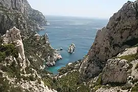 Sugiton
 Morgiou
 En-Vau
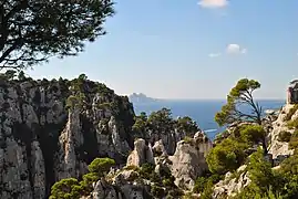 Belvédère
References
- Parc national des Calanques: "Carte d'identité" Archived 2013-06-16 at the Wayback Machine, retrieved 12 July 2013
- Parc national des Calanques: "Massif des Calanques" Archived 2013-06-16 at the Wayback Machine, retrieved 12 July 2013.
External links
| Metropolitan France | 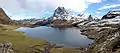 | |
|---|---|---|
| Overseas France | ||
| Authority control |
|---|