Camalú
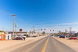
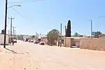
Camalú, Baja California, is a town on the Pacific coast Mexico's Baja California Peninsula. It is administered within the San Quintín Municipality. The census of 2010 reported a population of 8,621 inhabitants,[1] up from 6,333 in 2000.[2]
Camalú | |
|---|---|
 | |
Camalú Location in Mexico | |
| Coordinates: 30°50′16″N 116°03′26″W | |
| Country | |
| State | Baja California |
| Municipality | San Quintín |
| Elevation | 69 ft (21 m) |
| Population (2010) | |
| • City | 8,621 |
| • Urban | 8,621 |
| Time zone | UTC-8 (Northwest US Pacific) |
| • Summer (DST) | UTC-7 (Northwest) |
Surfing, dune buggy riding, sailing, fishing, clamming and crabbing are activities.
Though its considerably south of San Diego, water temperatures range from lows nearing 10°C(50°F) to highs approaching 21°C(70°F).[3] 3mm/2mm wetsuits are recommended for surfing on all but the warmest of days.
The main town is on Federal Highway 1, 175 km south of Tijuana. Drive time is about 2 hours south of Ensenada, some 30 km past Colonet town. For about 60 km (37 mi), from Colonet to El Rosario you can see the ocean from the highway. For five years, plans have been mulled for a major port in Colonet, with rail access to Yuma, Arizona, in the United States. However, demand and funding has not materialized.
Notes
- 2010 census tables: INEGI Archived May 2, 2013, at the Wayback Machine
- http://www.citypopulation.de/php/mexico-bajacalifornia.php
- Baja Expo Travel Guide - http://www.bajaexpo.com/water.htm