Yuma, Arizona
Yuma (Cocopah: Yuum) is a city in and the county seat[5] of Yuma County, Arizona, United States. The city's population was 93,064 at the 2010 census, up from the 2000 census population of 77,515.[3]
Yuma | |
|---|---|
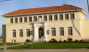 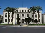 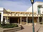 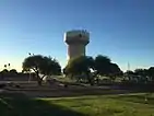 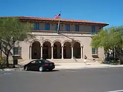 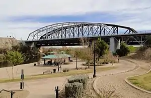 Clockwise from top: Old Yuma City Hall, Yuma Theatre, Old Yuma Post Office, Ocean to Ocean Bridge, Yuma water tower, Yuma County Courthouse | |
 Flag Seal | |
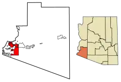 Location of Yuma in Yuma County, Arizona | |
 Yuma Location in the United States  Yuma Yuma (the United States) | |
| Coordinates: 32°41′32″N 114°36′55″W | |
| Country | |
| State | |
| County | |
| Incorporated | 1914 |
| Government | |
| • Type | Council-Manager |
| • Body | Yuma City Council |
| • Mayor Republican | Douglas J. Nicholls (R) |
| Area | |
| • City | 120.71 sq mi (312.63 km2) |
| • Land | 120.64 sq mi (312.45 km2) |
| • Water | 0.09 sq mi (0.18 km2) 0.07% |
| Elevation | 141 ft (43 m) |
| Population | |
| • City | 93,064 |
| • Estimate (2020)[4] | 100,015 |
| • Density | 814.70/sq mi (31.80/km2) |
| • Urban | 215,000 (US: 238th) |
| • Metro | 203,247 (US: 214th) |
| Demonym(s) | Yuman |
| Time zone | UTC−7 (MST (no DST)) |
| ZIP codes | 85364–85367, 85369, 85350 |
| Area code(s) | 928 |
| FIPS code | 04-85540 |
| GNIS ID(s) | 14111, 2412328 |
| Major airport | Yuma International Airport |
| Website | www.yumaaz.gov |
Yuma is the principal city of the Yuma, Arizona, Metropolitan Statistical Area, which consists of Yuma County. According to the United States Census Bureau, the 2020 estimated population of the Yuma MSA is 203,247.[6] More than 85,000 retirees make Yuma their winter residence.[7]
Yuma is in the state's southwest corner, in the Sonoran Desert, Yuma Desert sub-region.
History
The area's first settlers for thousands of years were Native American cultures and historic tribes. Their descendants now occupy the Cocopah and Quechan reservations.
In 1540, Spanish colonial expeditions under Hernando de Alarcón and Melchior Díaz visited the area and immediately recognized the natural crossing of the Colorado River as an ideal spot for a city. The Colorado River narrows to slightly under 1,000 feet (300 m) wide in one area. Military expeditions that crossed the Colorado River at the Yuma Crossing include Juan Bautista de Anza (1774), the Mormon Battalion (1848) and the California Column (1862).
During and after the California Gold Rush to the late 1870s, the Yuma Crossing was known for its ferry crossings for the Southern Emigrant Trail. This was considered the gateway to California, as it was one of the few natural spots where travelers could cross the otherwise very wide Colorado River.
First settlements
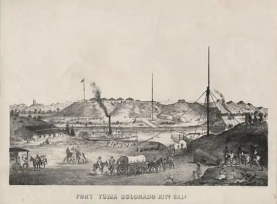
Following the United States establishing Fort Yuma, two towns developed one mile downriver. The one on the California side was called Jaeger City, named after the owner of Jaeger's Ferry, which crossed the river there. It was for a time the larger of the two, with the Butterfield Overland Mail office and station, two blacksmiths, a hotel, two stores, and other dwellings.[8]
The other was called Colorado City. Developed on the south side of the river in what is now Arizona by speculator Charles Poston, it was the site of the custom house. When started, it was just north of the border between Mexican-ruled Sonora, Mexico and California. After the Gadsden Purchase by the United States, the town bordered on the Territory of New Mexico. This area was designated as the Territory of Arizona in 1863. The Colorado City site at the time was duly registered in San Diego; both banks of the Colorado River just below its confluence with the Gila were recognized as being within the jurisdiction of California. The county of San Diego collected taxes from there for many years.[8][9]
From 1853 a smaller settlement, Arizona City, grew up on the high ground across from the fort and was organized under the name of its post office in 1858. It had adobe dwellings, two stores and two saloons. Colorado City and Jaeger City were almost completely destroyed by the Great Flood of 1862 and had to be rebuilt on higher ground. At that time Colorado City became part of Arizona City.[8][10] It took the name Yuma in 1873.
Early development
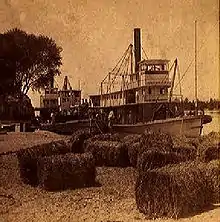
From 1854, Colorado City was the major steamboat stop for traffic up and down the Colorado River. After the 1862 flood, it became part of Arizona City. The steamboats transported passengers and equipment for the various mines and military outposts along the Colorado; Colorado City was the terminus of wagon traffic up the Gila River into New Mexico Territory. They offloaded the cargo from ships at the mouth of the Colorado River at Robinson's Landing and from 1864 at Port Isabel. From 1864, the Yuma Quartermaster Depot, today a state historic park, supplied all forts in present-day Arizona, as well as large parts of Colorado and New Mexico. After Arizona became a separate territory, Yuma became the county seat for Yuma County in 1871, replacing La Paz, the first seat.
The Southern Pacific Railroad bridged the river in 1877, and acquired George Alonzo Johnson's Colorado Steam Navigation Company, the only steamboat company on the river. Yuma became the new base of navigation on the river, ending the need for Port Isabel, which was abandoned in 1879. The warehouses and shipyard there were moved to Yuma.
Geography
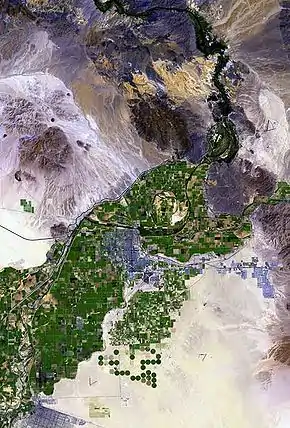
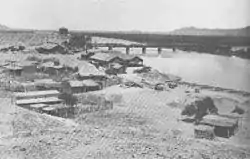
Yuma is near the borders of California to the west and Mexico to the south, and just west of the Gila River's confluence with the Colorado. The city is approximately 60 miles (100 km) from the Gulf of California (Sea of Cortez), a branch of the Pacific.
According to the United States Census Bureau, the city has a total area of 106.7 square miles (276 km2), of which 106.6 square miles (276 km2) is land and 0.1 square miles (0.26 km2) (0.07%) is water.
Climate
Yuma is noted for its weather extremes. Of any populated place in the contiguous United States, Yuma is the driest, the sunniest, and the least humid, has the lowest frequency of precipitation, and has the highest number of days per year—175—with a daily maximum temperature of 90 °F (32 °C) or higher.[11][12]
Yuma features a hot desert climate (Köppen climate classification BWh), with extremely hot summers and warm winters. Atmospheric humidity is usually very low except during what are called "Gulf surges", when a maritime tropical air mass from the Gulf of California is drawn northward, usually in connection with the summer monsoon or the passage of a tropical storm to the south.[13]
The sun is said to shine during about 90% of the daylight hours, making Yuma one of the sunniest places in the world.[14] The city receives the most recorded mean sunshine of anywhere on Earth,[12][15] although the equipment used by the United States tends to provide higher sunshine estimates than the traditional Campbell–Stokes recorder.[16]
On average, Yuma receives 3.36 inches (85 mm) of rain annually. Even in the wettest year of 2005, only 7.39 in (188 mm) fell. The driest year at Yuma Airport was 2007, with only 0.15 in (3.8 mm) recorded. On average, the wettest months of the year are August and September, influenced by the Southwestern U.S.'s "monsoon" these months, and December, influenced by moisture from winter-season storms arriving from the Pacific Ocean. Falling outside both these seasons, June is the driest month, with drought virtually absolute.
In 1995, Yuma reached its all-time high of 124 °F (51 °C).[17] The lowest recorded temperature was −6 °C (21 °F) on the Yuma-Mesa area in January 2007. The temperature fell to −6 °C (21 °F) for approximately two hours and harmed many crops grown in and around Yuma. The crop that suffered the most damage was the citrus on the Yuma mesa, most notably the lemon crop. It suffered a 75% to 95% loss of crop and trees, as stated by the Arizona Department of Agriculture in a February 2007 report. On average, the temperature lowers to the freezing mark in less than a quarter of years, and there are 118 days per year that reach or exceed 100 °F (38 °C), usually from April through October. During July and August the temperature fails to reach 100 °F (38 °C) on at most, only a few days.
In 1997, the desert city sustained a full tropical storm after Hurricane Nora made landfall at the mouth of the Colorado River and quickly moved due north along it. This rare event cut power to 12,000 customers in Yuma, and dropped 3.59 inches (91 mm) of rain at Marine Corps Air Station Yuma. The last time a hurricane had hit near Yuma was in mid-August 1977, when similar falls were recorded.
| Climate data for Yuma, Arizona (1981–2010 normals,[lower-alpha 1] extremes 1876–present) | |||||||||||||
|---|---|---|---|---|---|---|---|---|---|---|---|---|---|
| Month | Jan | Feb | Mar | Apr | May | Jun | Jul | Aug | Sep | Oct | Nov | Dec | Year |
| Record high °F (°C) | 88 (31) |
97 (36) |
102 (39) |
107 (42) |
120 (49) |
122 (50) |
124 (51) |
120 (49) |
123 (51) |
112 (44) |
98 (37) |
86 (30) |
124 (51) |
| Mean maximum °F (°C) | 79.4 (26.3) |
85.0 (29.4) |
92.9 (33.8) |
100.0 (37.8) |
106.8 (41.6) |
112.6 (44.8) |
114.7 (45.9) |
114.3 (45.7) |
110.8 (43.8) |
102.1 (38.9) |
89.1 (31.7) |
77.8 (25.4) |
116.2 (46.8) |
| Average high °F (°C) | 69.6 (20.9) |
73.8 (23.2) |
79.9 (26.6) |
86.4 (30.2) |
95.3 (35.2) |
103.5 (39.7) |
106.8 (41.6) |
106.2 (41.2) |
101.3 (38.5) |
89.9 (32.2) |
77.5 (25.3) |
68.3 (20.2) |
88.3 (31.3) |
| Average low °F (°C) | 47.6 (8.7) |
50.1 (10.1) |
54.4 (12.4) |
59.6 (15.3) |
67.3 (19.6) |
74.6 (23.7) |
82.1 (27.8) |
82.3 (27.9) |
76.8 (24.9) |
65.0 (18.3) |
53.9 (12.2) |
46.6 (8.1) |
63.4 (17.4) |
| Mean minimum °F (°C) | 37.3 (2.9) |
39.7 (4.3) |
43.9 (6.6) |
49.1 (9.5) |
56.4 (13.6) |
64.3 (17.9) |
74.1 (23.4) |
73.6 (23.1) |
65.3 (18.5) |
54.2 (12.3) |
43.1 (6.2) |
36.4 (2.4) |
34.6 (1.4) |
| Record low °F (°C) | 22 (−6) |
25 (−4) |
31 (−1) |
38 (3) |
39 (4) |
50 (10) |
61 (16) |
58 (14) |
50 (10) |
35 (2) |
29 (−2) |
22 (−6) |
22 (−6) |
| Average precipitation inches (mm) | 0.37 (9.4) |
0.39 (9.9) |
0.33 (8.4) |
0.15 (3.8) |
0.08 (2.0) |
0.01 (0.25) |
0.29 (7.4) |
0.47 (12) |
0.53 (13) |
0.21 (5.3) |
0.22 (5.6) |
0.51 (13) |
3.56 (90) |
| Average precipitation days (≥ 0.01 in) | 2.6 | 2.2 | 1.9 | 0.7 | 0.4 | 0.2 | 1.0 | 2.4 | 1.4 | 1.1 | 1.2 | 2.3 | 17.4 |
| Mean monthly sunshine hours | 268.4 | 270.8 | 335.5 | 365.5 | 407.4 | 415.4 | 392.6 | 375.6 | 341.7 | 319.6 | 270.1 | 252.7 | 4,015.3 |
| Percent possible sunshine | 84 | 88 | 90 | 94 | 95 | 97 | 90 | 91 | 92 | 91 | 86 | 81 | 90 |
| Average ultraviolet index | 3 | 5 | 7 | 8 | 10 | 10 | 11 | 10 | 9 | 6 | 4 | 3 | 7 |
| Source 1: NOAA[18][19][20] | |||||||||||||
| Source 2: Weather Atlas [21] | |||||||||||||
Snow in Yuma has only been recorded on December 12, 1932 when a light coating of snow covered the city for the first and last time in history. A few flakes fell in January 1937 and December 1967 mixed with rain.[22]
Demographics
| Historical population | |||
|---|---|---|---|
| Census | Pop. | %± | |
| 1860 | 130 | — | |
| 1870 | 1,144 | 780.0% | |
| 1880 | 1,200 | 4.9% | |
| 1890 | 1,773 | 47.8% | |
| 1900 | 1,519 | −14.3% | |
| 1910 | 2,914 | 91.8% | |
| 1920 | 4,237 | 45.4% | |
| 1930 | 4,892 | 15.5% | |
| 1940 | 5,325 | 8.9% | |
| 1950 | 9,145 | 71.7% | |
| 1960 | 23,974 | 162.2% | |
| 1970 | 29,007 | 21.0% | |
| 1980 | 42,481 | 46.5% | |
| 1990 | 54,923 | 29.3% | |
| 2000 | 77,515 | 41.1% | |
| 2010 | 93,064 | 20.1% | |
| 2019 (est.) | 98,285 | [4] | 5.6% |
| U.S. Decennial Census[23] | |||
Yuma first appeared on the 1860 U.S. Census as the village of "Arizonia" (Arizona City) in what was then Arizona County, New Mexico Territory (see Arizona City (Yuma, Arizona) for details). It returned as Arizona City in 1870 and then became Yuma in 1873. On April 12, 1902, the village of Yuma was incorporated as a town.[24] It formally incorporated as a city on April 7, 1914.[25]
As of the census of 2010, there were 93,064 people. There were 38,626 housing units in Yuma city, 79.5% of which were occupied housing units. The racial makeup of the city was 68.8% White, 3.2% Black or African American, 1.8% Native American, 1.9% Asian, 0.2% Pacific Islander, and 4.5% from two or more races. 54.8% of the population were Hispanic or Latino of any race.[26]
As of the census of 2000, there were 77,515 people, 26,649 households, and 19,613 families residing in the city. The population density was 726.8 people per square mile (280.6/km2). There were 34,475 housing units at an average density of 323.3 per square mile (124.8/km2). The racial makeup of the city was 68.3% White, 3.2% Black or African American, 1.5% Native American, 1.5% Asian, 0.2% Pacific Islander, 21.4% from other races, and 3.9% from two or more races. 45.7% of the population were Hispanic or Latino of any race.
There were 26,649 households, out of which 38.8% had children under the age of 18 living with them, 56.6% were married couples living together, 13.1% had a female householder with no husband present, and 26.4% were non-families. 21.7% of all households were made up of individuals, and 9.8% had someone living alone who was 65 years of age or older. The average household size was 2.79 and the average family size was 3.27.
In the city, the population was spread out, with 29.6% under the age of 18, 11.9% from 18 to 24, 27.1% from 25 to 44, 17.5% from 45 to 64, and 13.9% who were 65 years of age or older. The median age was 31 years. For every 100 females, there were 99.1 males. For every 100 females age 18 and over, there were 97.2 males.
According to the 2006 American Community Survey estimate, the median income for a household in the city was $39,885, and the median income for a family was $41,588. Males had a median income of $35,440 versus $27,035 for females. The per capita income for the city was $18,393. About 14.1% of families and 16.9% of the population were below the poverty line, including 23.4% of those under age 18 and 13.9% of those age 65 or over.
High unemployment remains an issue in Yuma. Citing April 2014 data, the Bureau of Labor Statistics ranked Yuma as having the highest unemployment rate in the United States at 23.8 percent, above the 21.6 percent in El Centro, California.[27] Yuma's agricultural workforce, which adjusts to the picking season, is cited by the Arizona Department of Commerce as the reason for the apparent high unemployment.[28]
Economy
(NRCS_Photo_Gallery).tif.png.webp)
The Yuma Metropolitan Statistical Area has the highest unemployment rate in the United States as of 2018 at 20.9%.[29] A large percentage of the work force is employed seasonally in agriculture, contributing to apparent unemployment.
Yuma is colloquially referred to as the “Winter Lettuce Capital of the World”.[30]
On New Year's Eve, 2018 the town of Yuma dropped a head of iceberg lettuce from the town's water tower, to symbolize the beginning of the new year, much like the ball drop in New York City's Times Square. This is known as the “Iceberg Drop”.[31]
Top employers
According to the city's 2019 Comprehensive Annual Financial Report,[32] the top employers in the Yuma Metropolitan Statistical Area in 2018 were:
| # | Employer | # of employees |
|---|---|---|
| 1 | Marine Corps Air Station Yuma | 5,568 |
| 2 | Yuma Union High School District | 3,100 |
| 3 | U.S. Army Yuma Proving Ground | 2,382 |
| 4 | Yuma Regional Medical Center | 2,300 |
| 5 | Yuma County | 1,437 |
| 6 | Yuma Elementary School District | 1,400 |
| 7 | City of Yuma | 1,274 |
| 8 | TRAX | 1,125 |
| 9 | United States Border Patrol | 1,000 |
| 10 | Arizona Western College | 987 |
Other large employers include Bose, Dole Fresh Vegetables and Shaw Industries.[33]
Arts and culture
.jpg.webp)
Yuma contains the historical Yuma Territorial Prison, the Yuma Quartermaster Depot State Historic Park (formerly known as the Yuma Crossing Historic Park), and a historic downtown area. Yuma is an Arizona Main Street City. Because of budget cutbacks at the state level, Arizona State Parks no longer operates the Territorial Prison and Quartermaster Depot. They are now operated by the Yuma Crossing National Heritage Area and the City of Yuma. The Yuma Visitors' Bureau oversees the Welcome Center at the Quartermaster Depot and is the official visitors' center for the Yuma Community.
Near Yuma are the Kofa Mountain Range and wildlife refuge, Martinez and Mittry Lakes, and the Algodones Dunes.
The city is the location of the Marine Corps Air Station Yuma, which conducts an annual air show and many large-scale military exercises. There is also the Yuma Proving Ground, an Army base that tests new military equipment. Yuma Proving Ground is also home to the Special Operations Free Fall School, which provides training in free-fall parachute operations to Special Forces units in all branches of service, as well as those of other nations.
The Colorado River runs along the north and west side of town, serving as the border between Arizona and California. Yuma is an important station for trucking industry movement of goods between California, Arizona and Mexico.
The Rialto movie theatre once owned a Kilgen pipe organ, one of the most expensive pipe organs to have been made. Originally played as accompaniment to silent films, it has been moved to the Yuma Theatre.
Every February residents and visitors enjoy the annual rodeo, the Yuma Jaycees Silver Spur Rodeo. A parade opens the events. Cowboys and cowgirls from all over the country compete in the festivities.
The Yuma County Fair takes place annually in the spring at the fairgrounds in Yuma.
Filming
A number of movies have been shot in the Yuma area, including The Sheik (1921), Beau Geste (1926), Beau Geste (1939), Beau Geste (1966), Gunga Din (1939), Flight of the Phoenix (1966), Return of the Jedi (1983) and Spaceballs (1987).[34]
Sports
Yuma has a minor-league-caliber ballpark, Desert Sun Stadium, which was home to the Yuma Desert Rats of the North American League and site of home games of two (previously four) teams for the Arizona Winter League.[35] The San Diego Padres used the field as a spring training facility from 1969 until 1993[36] and a Japanese baseball team, the Yakult Swallows, used the field for spring training from 1995 to 2015.[37] Many local club sports exist in the area as well, including the Yuma Sidewinders Rugby Football Club. The rugby team participates in the Division III Arizona Men's Rugby league, and travels throughout Arizona, California and Nevada, as well as playing home games in Yuma.
Government
Organization
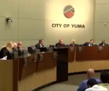
The city of Yuma operates as a charter city under the Charter of the City of Yuma.[38] The elected government of the city is the City Council which follows the mayor–council government system and whose members include:
Mayor
The Mayor of the City of Yuma acts as the chief executive officer of the city, and is elected for a period of four years. The mayor is elected from the city at large. The mayor has the following powers and responsibilities: act as an ex officio chairman of the city council (ensuring all ordinances thereof are enforced), call and preside over meetings, administer oaths and issue proclamations. The mayor is also recognized as the official head of the city by the courts and has the power to take command of the police and govern the city by proclamation during times of great danger.[38]
City Council
The City of Yuma City Council is the governing body of the City of Yuma and is vested with all powers of legislation in municipal affairs. The council is composed of six council members elected from the city at large for four-year terms, as well as the Mayor of Yuma. A deputy mayor is also elected by the Council who shall act as Mayor during the temporary absence of the mayor. Karen Watts became the most recent Deputy Mayor in 2020. The current council members are Gary Knight, Leslie McClendon, Jacob Miller, Edward Thomas, Mike Shelton, and Karen Watts. The next election is the August 2019 Primary for the three city council seats that are currently held by Miller, Thomas, and Shelton. [38]
City Administrator
The City Council appoints a city administrator who acts as the chief administrative officer of the city. The city administrator is directly responsible to the City Council for the administration of all city affairs placed in his charge by the City Charter, or by ordinances passed by the council. Some of the administrator's duties include: see that all laws and provisions of the City Charter are faithfully executed, prepare and submit the annual budget and capital program to the City Council and keep the City Council fully advised as to the financial condition and future needs of the city.[38]
Education

The city is zoned to the Yuma Union High School District. Yuma has five public high schools: Yuma Union High School, Kofa High School, Cibola High School, Gila Ridge High School, Vista Alternative High School; and the private Yuma Catholic High School and Calvary Baptist School. Yuma also has four charter high schools: AZTEC High School, Desert View Middle & High School, Harvest Preparatory Academy, and YPIC Charter High School.
Yuma has two main elementary school districts, District One and Crane District, which include several schools as well as junior high schools. Yuma has four charter elementary school: AmeriSchools Academy North and South, Harvest Preparatory Academy, and Desert View Academy.
Additionally, Yuma has 6 six private elementary schools: Yuma Lutheran School, Yuma Adventist Christian School, Immaculate Conception School, St. Francis of Assisi School, Calvary Baptist School and Southwestern Christian School.[39]
Arizona Western College is Yuma's community college, serving primarily as a choice for transfer students and those with shorter career goals.
Northern Arizona University has a branch campus in Yuma, as does the for-profit University of Phoenix.
Yuma is served by the Yuma County Library District which consists of a Main Library and several branches, including sites in Somerton, Wellton, Fortuna Foothills, and San Luis. A new main state-of-the-art library is now open.
Media
- Yuma Sun newspaper
- KECY-TV FOX, ABC, CW and Telemundo Affiliate
- KYMA-DT NBC and CBS Affiliate
- KCFY 88.1 KCFY Christian Radio
- KAWC-FM 88.9 FM Public Radio (Arizona Western College)
- KYRM 91.9 FM Radio Manantial
- KLJZ 93.1 FM Adult Contemporary Radio
- KTTI 95.1 FM Country Radio
- XHMIX 98.3 FM Top 40 Radio
- KQSR 100.9 FM Adult Contemporary Radio
- KCEC 104.5 FM Regional Mexican Radio
- KBLU 560 AM Talk Radio
- KOFA 1320 AM Public Radio (Arizona Western College)
- KCYK 1400 AM Country Radio
Transportation
Notable people
- Alex Barrett (born 1994), American football player
- Ryan Bedford, Olympic speed skater
- Darrell Bevell Detroit Lions' Offensive Coordinator
- Charles Brinley, actor of the silent era
- Cesar Chavez, Mexican American civil rights leader
- Tom Childs, miner and rancher
- Curley Culp, NFL player for Kansas City Chiefs, member of Pro Football Hall of Fame
- Jason DeCorse, guitarist for The Icarus Line
- Efrain Escudero, NCAA All-American wrestler, mixed martial artist, UFC fighter, and Ultimate Fighter Season 8 reality TV show champion
- Edgar Garcia, current mixed martial artist, and former UFC and WEC fighter
- Irving Garcia, USL Pro player for Los Angeles Blues
- Kelvin Gastelum, Ultimate Fighter 17 reality TV show champion, and UFC fighter in the Middleweight division.
- Bill Hudson, Alaska state legislator
- Ron Jessie, NFL wide receiver for Los Angeles Rams
- Robert Wilson Kennerly, retired politician and community leader
- Curtis Lee, singer
- Jonathan Lines, businessman, Chair of Arizona Republican Party
- Jose Maria Redondo, entrepreneur and former mayor of Yuma
- Mike Marshall, manager of Yuma Scorpions, won two World Series rings with Los Angeles Dodgers
- Bengie Molina, Major League Baseball catcher for the Texas Rangers; played shortstop for Arizona Western College in 1991 and 1992
- Bobby Pacho, 1930s professional boxer and Welterweight world title contender
- Bob Porter, major league baseball player
- DeForest Porter, mayor of Phoenix; Justice, Arizona Territory Supreme Court[41]
- John Shanssey, boxer, gambler, saloon owner, and Mayor of Yuma
- Cain Velasquez, UFC heavyweight champion, All-American collegiate wrestler
- Roger L. Worsley, educator; lived in Yuma, 1959 to 1963
See also
Notes
- Mean monthly maxima and minima (i.e. the highest and lowest temperature readings during an entire month or year) calculated based on data at said location from 1981 to 2010.
References
- "2019 U.S. Gazetteer Files". United States Census Bureau. Retrieved June 30, 2020.
- "Feature Detail Report for: Yuma". Geographic Names Information System. United States Geological Survey.
- "U.S. Census website". United States Census Bureau. Retrieved 2015-06-03.
- "Population and Housing Unit Estimates". United States Census Bureau. May 24, 2020. Retrieved May 27, 2020.
- "Find a County". National Association of Counties. Archived from the original on May 31, 2011. Retrieved 2011-06-07.
- United States Census Bureau. "Annual Estimates of the Population of Metropolitan and Micropolitan Statistical Areas: April 1, 2010 to July 1, 2020". Archived from the original on May 10, 2015. Retrieved 2015-06-03.
- "City of Yuma". Greater Yuma Economic Development Corporation. Archived from the original on 2007-09-29. Retrieved 2007-06-23.
- Richard E. Lingenfelter, Steamboats on the Colorado River, 1852–1916, University of Arizona Press, Tucson, 1978 Archived 2016-01-18 at the Wayback Machine, p.15
- "Chapter Xix. Early Settlements And First Attempts At Organization Of Territory". Southwest.library.arizona.edu. Retrieved 2011-03-27.
- Thomas Edwin Farish, History of Arizona, Volume I. The Filmer Brothers Electrotype Company, San Francisco, 1915. pp. 252–253
- "Mean Number of Days Maximum Temperature 90 Deg. F or Higher". Comparative Climatic Data for the United States Through 2012. National Oceanic and Atmospheric Administration: U.S. Dept. often Commerce. 2013. Archived from the original on 2013-11-06.
- "Extremes in U.S. Climate". National Climate Data Center.
- Duginski, Paul (August 22, 2019). "Could a hurricane lash Los Angeles? 80 years ago, this deadly storm came close". Los Angeles Times. Retrieved August 28, 2019.
- "Fact sheet No. 9 – Weather extremes" (PDF). Archived from the original (PDF) on 2016-06-04. Retrieved 2016-05-16.
- Osborn, Liz. "Sunniest Places and Countries in the World". Current Results Nexus.
- Matuszko, D. Theor Appl Climatol (2015) 119: 401. doi:10.1007/s00704-014-1125-z
- "Intellicast – Yuma Historic Weather Averages in Arizona (85365)". Retrieved 15 January 2017.
- "NOWData - NOAA Online Weather Data". National Weather Service. Retrieved 2019-10-25.
- "Station Name: AZ YUMA MCAS - COOP". National Oceanic and Atmospheric Administration. Retrieved 2019-10-25.
- "FTP NOAA Weather Data file". National Oceanic and Atmospheric Administration. Retrieved 2016-04-12.
- "Yuma, Arizona, USA - Monthly weather forecast and Climate data". Weather Atlas. Retrieved 2019-05-17.
- "Climatological Data: Arizona section". 1929.
- "Census of Population and Housing". Census.gov. Retrieved June 4, 2016.
- "Today in Arizona History". 2019-04-03.
- "Yuma Marks 100th Birthday Next Week".
- Bureau, U.S. Census. "American FactFinder – Results". Archived from the original on 12 February 2020. Retrieved 15 January 2017.
- "Unemployment Rates for Metropolitan Areas". Bls.gov. Retrieved 2014-06-25.
- "Yuma unemployment rate among nation's highest". Retrieved 15 January 2017.
- "Unemployment Rates for Metropolitan Areas". Retrieved 15 January 2017.
- "Agriculture – Yuma County Chamber of Commerce". www.yumachamber.org. Retrieved 2019-07-15.
- "Lettuce Drop – Welcome To Yuma, Arizona – On The River's Edge". www.visityuma.com. Retrieved 2019-07-15.
- "Comprehensive Annual Financial Report" (PDF). City of Yuma, Arizona. 2019.
- Yuma Area Employers Archived 2011-04-05 at the Wayback Machine, Greater Yuma website
- Barth, Jack (1991). Roadside Hollywood: The Movie Lover's State-By-State Guide to Film Locations, Celebrity Hangouts, Celluloid Tourist Attractions, and More. Contemporary Books. Page 33. ISBN 9780809243266.
- "Yuma Scorpions". Goldenbaseball.com. Archived from the original on 2011-02-11. Retrieved 2011-03-27.
- Amanda Branam / Special to MLB.com (2007-03-24). "Padres still enjoy their time in Yuma". Mlb.mlb.com. Archived from the original on 2017-10-28. Retrieved 2011-03-27.
- "SD Padres Spring Training in Yuma". Caballeros.org. 2008-03-22. Archived from the original on 2011-07-25. Retrieved 2011-03-27.
- "Yuma City Code: Yuma, Arizona". American Legal Publishing Corporation. American Legal Publishing Corporation. Retrieved 15 May 2018.
- "Schools & School Calendar". Yuma County Superintendent's Office. Retrieved 15 January 2017.
- "Public Transportation". ci.quartzsite.az.us. Retrieved 15 January 2017.
- Goff, John S. (1975). Arizona Territorial Officials Volume I: The Supreme Court Justices 1863–1912. Cave Creek, Arizona: Black Mountain Press. p. 65. OCLC 1622668.
External links
| Wikimedia Commons has media related to Yuma, Arizona. |
| Wikivoyage has a travel guide for Yuma, Arizona. |
- City of Yuma Website
- Yuma Convention and Visitors Bureau Website
- Yuma Stats
- "Yuma, Arizona". C-SPAN Cities Tour. May 2013.
Municipalities and communities of Yuma County, Arizona, United States | ||
|---|---|---|
| Cities | 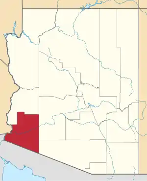 | |
| Town | ||
| CDPs | ||
| Populated places | ||
| Indian reservations | ||
| Ghost towns | ||
| Footnotes | ‡This populated place also has portions in an adjacent county or counties | |
| ||
| Authority control |
|---|