Camp Chase Trail
The Camp Chase Trail is a paved multi-use trail in Madison and Franklin counties in the U.S. state of Ohio. It serves as the Southwest Columbus segment of the 326-mile (525 km)[1] Ohio to Erie Trail. The entire length of the Camp Chase Trail is part of U.S. Bicycle Route 50, a west-east bicycle route across Ohio connecting Indiana to West Virginia.[2][3]
| Camp Chase Trail | |
|---|---|
| Length | 16 mi (26 km) |
| Location | Madison and Franklin counties, Ohio, United States |
| Designation | |
| Trailheads | Lilly Chapel to N. Eureka Ave. in Columbus, Ohio |
| Use | Paved Multi-use |
| Hiking details | |
| Trail difficulty | Easy (fully accessible) |
| Season | Year-round |
History
Camp Chase Trail is a "rail with trail" project, named for the Camp Chase Railway it parallels. During the American Civil War, Camp Chase was a military staging and training camp for Union forces, and a prison camp for Confederates. All that remains of the camp today is a Confederate Cemetery containing 2,260 graves, located at 2900 Sullivant Ave. It was named for former Ohio Governor and Lincoln's Secretary of the Treasury Salmon P. Chase. Four future Presidents passed through Camp Chase as Union soldiers: Andrew Johnson, Rutherford B. Hayes, James Garfield, and William McKinley.
Location
- West terminus west of Lilly Chapel (and east terminus of Roberts Pass): 39°53′23.3″N 83°18′50.8″W
- East Terminus in Columbus at N. Eureka Ave: 39°57′48.8″N 83°03′59.5″W
Route
The Camp Chase Trail is 16.2 miles (26.1 km),with 3 miles (4.8 km) in Madison County and 13.2 miles (21.2 km) in Franklin County. The Camp Chase Trail extends from Lilly Chapel (Roberts Pass Trail) to the Columbus Hilltop Neighborhood where it connects to the Scioto Greenway Trail. The approximate midpoint of the trail is in Battelle Darby Creek Metro Park where it crosses the confluence of the Big and Little Darby Creeks.
Detailed route
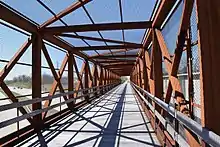
The Camp Chase Trail has been complete from the conjunction with the Roberts Pass trail at the Wilson Road Trailhead in Madison County, Ohio to the intersection with Sullivant Avenue in Franklin County since 2015.[4] The City of Columbus approved funding for the final 3 miles of the Camp Chase Trail from Georgesville Road to North Eureka Ave. on November 3, 2014.[5] and completed it December 2016. In July 2019, the trail connector parallel to Georgesville Road and Sullivant Ave was opened and replaced the Industrial Mile Road section of the trail. From the trail access at Georgesville Road, the trail continues north to N. Eureka Ave where the Ohio to Erie Trail route continues on N. Eureka Ave (North) to Valleyview Dr (East) which changes names to N. Highland Ave, then Harper Rd where the route crosses McKinley Ave. and utilizes the Hilltop Connector bridge to connect to the Scioto Greenway Trail.
The Ohio to Erie Trail is marked on the short road route to the Hilltop Connector bridge, where it joins the Scioto Greenway Trail. For the most part, the Camp Chase Trail is paved, with the exception of the connector through the Battelle Darby Creek Metro Park, which is crushed, packed limestone.
For navigation, it is important to note that Camp Chase trail is in proximity to two roads named "Wilson Road", one in each county, Wilson Road Park is in Columbus (Franklin County) at 275 S. Wilson Road.
Communities adjacent to the trail
Trailside amenities

- Southern Trail head: Roberts Pass Trail Wilson Rd London, OH 43140 [Portable Restroom, Bike Rack, Car Parking, No Water] 39°53′24″N 83°18′48″W
- Lily Chapel Trail side Shelter: [Covered 2-Sided Shelter, Picnic Table, Bike Rack]
- Battelle Darby Creek Trail head: 8465 Alkire Rd, Galloway, OH 43140 [Restrooms, Picnic Area, Canoe Access, Car Parking, Indian Ridge Pump (well) water] 39°53′37″N 83°12′57″W
- Columbus Wilson Road Park, 275 S. Wilson Road, Columbus, OH 43204 39°56′52″N 83°05′52″W [Drinking Fountain, Portable Restroom, Lighted Picnic Area, Bike Repair Station and tire pump, Parking Lot]
- Northern Trailhead: north of Columbus Holton Park Columbus, OH 43204, approximately at 375 N Eureka Ave.39°57′42″N 83°04′02″W
Local attractions
- Battelle Darby Creek Metro Park. 8465 Alkire Road, Galloway OH 43119; 39°53′36″N 83°12′57″W
- Camp Chase Confederate Cemetery 39°56′38″N 83°04′33″W
- National Road Historical Markers [6][7]
- Columbus Recreation and Parks, Wilson Road Park trail head to Camp Chase Trail [8][9]
- Hollywood Casino Columbus
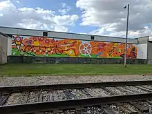
- Movin' & Groovin' Mural, by artist Roger J Williams commissioned for the 2017 Summer Jam West; visible from the trail just east of N. Sylvan Ave. 39°57′25″N 83°05′11″W [10]
- Columbus Recreation and Parks, West Side: Big Run Park and Athletic Complex, Westgate Park, WestmoorPark, Holton Park, Glenview Park
Milestones
- March 21, 2012: Trail bridge over Darby Creek brings the trail into Battelle Darby Creek Metro Park [11]
- October 10, 2013: The Friends of the Camp Chase Trail held their first meeting at the Haydocy Automotive Community Room. Area citizens met with members of the Friends of Madison County Parks and Trails to discuss creating a similar function for the Camp Chase Trail.[12]
- November 15, 2013: Completion of the Trail segment east of Battelle Darby Creek Metro Park [1]
- April 8, 2014: Friends of the Camp Chase Trail introduced the trail at the Westland Area Business Association Meeting at Darby Dan Farm.[13]
- July 14, 2014: WSA Studio presented to the friends of Camp Chase Trail and Community Stakeholders regarding the Wilson Road Trailhead at the Haydocy Community Room.[14]
- October 12, 2014: Camp Chase Trail partnered with the Friends of Madison County Parks and Trails to host a table at Darby Creek Days at Battelle Darby Creek Metro Park an event held annually in the Indian Ridge section of the park.
- November 3, 2014: Columbus City Council approves funding to construct the Camp Chase Trail between Georgesville Road and North Eureka Ave.
- November 13, 2014: Paving completed on the Camp Chase Trail between Alton Road and Galloway Road.
- March 28, 2015: Camp Chase Trail Day was celebrated at Battelle Darby Creek Metro Park[15][16]
- October 30, 2015, Friends of Camp Chase Trail hosted the Opening Trail Ride on the newest 3 mile section between Galloway Road and Sullivant Ave, including the 100 Yard bridge over Interstate 270. 36 trail friends were in attendance.[17]
- December 5, 2015, The Camp Chase Trail Hilltop Action Team was established to monitor conditions in the trail corridor for the trail area from Georgesville Road to N. Eureka Ave. The Columbus Westside Running Club was formed by meeting attendees and began holding group runs at Columbus Westgate Park on January 12, 2016.
- December 1, 2016, The Camp Chase Trail is fully paved between Georgesville Road and N. Eureka Ave which represents the conclusion of the major construction of Camp Chase Trail.
- July 20, 2017, City of Columbus Recreation and Parks Department hosted the dedication of the new Wilson Road Park and Camp Chase Trailhead at 275 S. Wilson Road, Columbus, OH 43204 [18]
- July 7, 2018, the Hilltop U.S.A. 5K is the first timed race on the Camp Chase Trail.[19]
See also
References
- Rouan, Rick (8 October 2013). "Statewide bike path beckons". Columbus Dispatch. Retrieved 30 March 2014.
- Vitale, Marty (May 29, 2014). "Report to SCOH". Louisville, Kentucky: Special Committee on U.S. Route Numbering, American Association of State Highway and Transportation Officials. Archived from the original (Office Open XML) on 2014-05-31. Retrieved June 1, 2014.
- Townley, Jennifer (April 10, 2014). "USBR 50 update" (PDF). Ohio Department of Transportation. Retrieved June 1, 2014.
- Latimer, Sandi (25 March 2014). "County working on Camp Chase Trail issues". Columbus Messenger. Retrieved 30 March 2014.
- Sullivan, Lucas (4 November 2014). "Columbus approves $4.2 million to link Camp Chase trail on West Side". The Columbus Dispatch. Retrieved 25 November 2014.
- "National Road Historical Marker". Remarkable Ohio. Ohio History Connection. Archived from the original on 23 November 2015. Retrieved 23 November 2015.
- "ODOT Historic National Road Byway". Ohio Department of Transportation. Retrieved 30 March 2014.
- Bell, Jeff (15 March 2013). "Biking hub pitched as development booster on west side". Columbus Business First. Retrieved 30 March 2014.
- "Wilson Road Park". The City of Columbus, Recreation and Parks Department. Retrieved 6 August 2017.
- Williams, Roger J. "Movin' and Groovin' Mural". Summer Jam West. Retrieved 6 August 2017.
- Zurbrick, Kristy (16 March 2012). "First phase of Camp Chase Trail completed". Columbus Messenger. Retrieved 30 March 2014.
- Friends of Camp Chase Trail (20 September 2013). "Friends of Camp Chase Trail Meeting". Ohio to Erie Trail. Retrieved 30 March 2014.
- "WABA Westland Area Business Association". Archived from the original on 18 December 2014. Retrieved 9 April 2014.
- WSA Studio. "Wilson Road Trailhead Community Meeting". wsastudio.com/. Archived from the original on 2014-08-08. Retrieved 16 July 2014.
- Wartenberg, Steve. "Camp Chase Trail Day". Columbus Dispatch Best Bike Blog Ever. Retrieved 17 March 2015.
- Wartenberg, Steve. "The C-C-Camp C-C-Chase Trail ride was..." www.dispatch.com. Columbus Dispatch. Retrieved 24 April 2015.
- "Champ Chase Opening - Galloway Road to Sullivant Ave (10/30/2015)". Friends of Madison County Parks and Trails. Archived from the original on 23 November 2015. Retrieved 23 November 2015.
- Tomlinson, Miranda (20 July 2017). "Columbus' west side gets first city park in 15 years". Columbus Business First. Retrieved 6 August 2017.
- "Hilltop U.S.A. 5K". runsignup. Retrieved 4 May 2018.
External links
| Wikivoyage has a travel guide for Camp Chase Trail. |
- Central Ohio Greenways website and maps
- Camp Chase Trail website
- Camp Chase Trail Locator Chart
- Metro Parks Greenway Trails
- Map in TrailLink
- Maps at Friends of Madison County Parks and Trails
- Friends of Camp Chase Trail on Facebook
- Camp Chase Trail on Twitter
- Battelle Darby Creek Metro Park Map including the Camp Chase Trail
- Battelle Darby Creek Metro Park Website
- Little Pennsylvania Cemetery (Woolyburger Cemetery) Darbydale, Ohio