Canaro, Rovigo
Canaro is a comune (municipality) in the Province of Rovigo in the Italian region Veneto, located about 80 kilometres (50 mi) southwest of Venice and about 15 kilometres (9 mi) southwest of Rovigo. As of 31 December 2004, it had a population of 2,885 and an area of 32.7 square kilometres (12.6 sq mi).[3]
Canaro | |
|---|---|
| Comune di Canaro | |
.jpg.webp) Santa Sofia, the Parish church, and the Town Hall | |
Location of Canaro 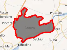
| |
 Canaro Location of Canaro in Italy 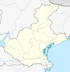 Canaro Canaro (Veneto) | |
| Coordinates: 44°56′N 11°40′E | |
| Country | Italy |
| Region | Veneto |
| Province | Rovigo (RO) |
| Frazioni | Baruchella, Boccalara, C. Benvenuto Tisi, C. Mella, C. Ruggieri, Ca' Matta, Croce del Sud, Crociara, Garofolo, Giaretta, La Frattina, Mezzavia, Paviole, Tenasi, Valiera, Vallone, Viezze |
| Area | |
| • Total | 32.7 km2 (12.6 sq mi) |
| Population (Dec. 2004)[2] | |
| • Total | 2,885 |
| • Density | 88/km2 (230/sq mi) |
| Demonym(s) | Canarini |
| Time zone | UTC+1 (CET) |
| • Summer (DST) | UTC+2 (CEST) |
| Postal code | 45034 |
| Dialing code | 0425 |
| Website | Official website |
Geography
The municipality of Canaro contains the frazioni (subdivisions, mainly villages and hamlets) Baruchella, Boccalara, C. Benvenuto Tisi, C.Mella, C.Ruggieri, Ca' Matta, Croce del Sud, Crociara, Garofolo, Giaretta, La Frattina, Mezzavia, Paviole, Tenasi, Valiera, Vallone, and Viezze.
Canaro borders the following municipalities: Ferrara, Fiesso Umbertiano, Frassinelle Polesine, Occhiobello, Polesella and Ro.
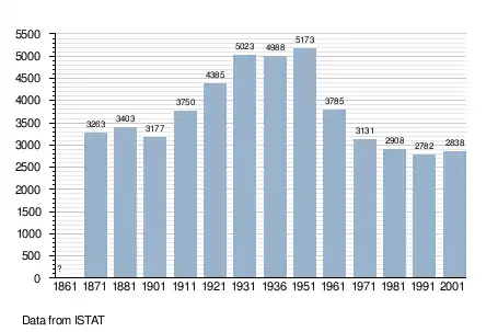
Demographic evolution
References
- "Superficie di Comuni Province e Regioni italiane al 9 ottobre 2011". Istat. Retrieved 16 March 2019.
- "Popolazione Residente al 1° Gennaio 2018". Istat. Retrieved 16 March 2019.
- All demographics and other statistics: Italian statistical institute Istat.
This article is issued from Wikipedia. The text is licensed under Creative Commons - Attribution - Sharealike. Additional terms may apply for the media files.