Canoe Landing Park
Canoe Landing Park is an 8 acres (3.2 ha)[1] privately funded[2] urban park in downtown Toronto, Ontario, Canada, adjacent to the Gardiner Expressway that received its name on November 2009. The name was chosen as part of a city-run contest and the final name was announced on the t.o.night free evening commuter paper. Formerly, it was tentatively known as CityPlace Park.
| Canoe Landmark | |
|---|---|
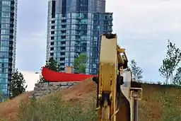 The Red Canoe at Canoe Landing Park | |
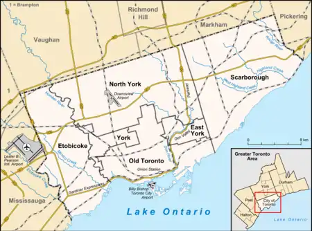 Location of the park in Toronto | |
| Type | Urban Park |
| Location | 95 Fort York Boulevard Toronto, Ontario, Canada |
| Coordinates | 43°38′20″N 79°23′48″W |
| Area | 8 acres (3.2 ha) |
| Created | 2009 |
| Operated by | City of Toronto |
The park's ribbon cutting ceremony was on September 9, 2009. The Park was designed by Landscape Architects Phillips Farevaag Smallenberg of Vancouver in collaboration with Landscape Architects, The Planning Partnership of Toronto, Public Art Consultant Karen Mills and Douglas Coupland. The park incorporates integrated artwork in the form of a landform (the bluff) and stand alone art pieces by Douglas Coupland: a canoe large enough for people to stand in and see over the Gardiner to Lake Ontario, a colourful display of large fishing bobbers, a sculptural beaver dam, programmed tree lighting (which will be more evident as the trees fill out), a pair of "iceberg benches" situated near the canoe, the "heart-shaped stone" bronze artwork which was cast from a stone retrieved by Terry's brother at the end of his journey and a one-mile run called the Terry Fox Miracle Mile.
The developers of Concord CityPlace are Concord Adex Developments. On the advice of their consultant, Karen Mills, Concord approached Douglas Coupland, the Vancouver author, artist and sculptor. Some of Douglas Coupland's other recent Toronto projects include Super Nova, a sculptural work/clock tower in North York (at the Don Mills Centre) and "Monument to the War of 1812," situated on Fleet and Bathurst street corner (just south of Old Fort York).
The canoe promontory was created as part of a proposed "earthwork" identified in the public art masterplan for Concord CityPlace (Public Art Management, Karen Mills, 1999) and was made from on site excavated fill and geosynthetic reinforcements.[3] The hill has an elevation that allows viewers to see over the Gardiner Expressway to Lake Ontario. Some 20,000-25,000 dumptruck loads of fill were diverted from landfills.
See also
References
- PFS Studio Commons Projects, archived from the original on 2014-08-26, retrieved 2014-08-23
- 2011 Toronto Urban Design Awards Submissions: Large Places or Neighbourhood Designs (PDF), retrieved 2011-12-05
- "Hill with no name a 'big deal'". Retrieved 2009-10-02.
External links
| Wikimedia Commons has media related to Canoe Landing. |
National Post article by Peter Kuitenbrouwer
Toronto Star video by Bernard Weil
Toronto Star article by Christopher Hume
Toronto Star article by Vanessa Lu
Globe & Mail article by Kate-Marie Gardner