Cape Atholl
Cape Atholl (Danish: Kap Atholl), also known as Kangaarasuk, is a headland in Northwest Greenland, Avannaata municipality.
| Cape Atholl | |
|---|---|
| Kap Atholl, Kangaarasuk | |
 | |
| Location | NW Greenland |
| Coordinates | 76°23′N 69°38′W |
| Offshore water bodies | Bylot Sound Baffin Bay |
| Elevation | 230 metres (755 feet) |
| Area | Arctic |
This cape was named by Commander James Saunders, after Atholl, the class to which his ship HMS North Star belonged, during the winter 1849–50 in which he was frozen in the bay to the north and named landmarks in the area.[1]
History
Cape Atholl was a United States Coast Guard LORAN station in Northwest Greenland, south of Thule Air Base. It was established in 1954 and disestablished in 1975.[2] The station was located at Quaratit, about 11 kilometres (7 miles) southeast of Cape Atholl proper.[3]
- Latitude: 76°18'56.62"N
- Longitude: 69°21'21.03"W
Geography
Cape Atholl is located in the mainland, in the eastern shore of Bylot Sound, Baffin Bay.[4] It rises at the southern end of the mouth of Wolstenholme Fjord and opposite the eastern end of Wolstenholme Island.[3]
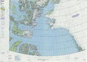 Map of Northwestern Greenland |
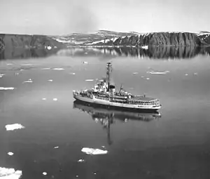 USCGC Westwind near Cape Atholl, Greenland, returning from Arctic cruise (1964). |
References
- The Nautical Magazine and Naval Chronicle, Simpkin, Marshall & Co. London 1850, p. 588
- Fact Sheet at LORAN History Site
- Prostar Sailing Directions 2005 Greenland and Iceland Enroute, p. 85
- "Kap Atholl". Mapcarta. Retrieved 29 May 2019.