Cape Fie
Cape Fie (Norwegian: Kapp Fie), located at 54°27′S 3°28′E, is a cape marking the southeast extremity of Bouvetøya in the South Atlantic Ocean. It was first roughly charted in 1898 by a German expedition under Carl Chun, and was re-charted and named by the Norwegian expedition under Captain Harald Horntvedt who explored the area from the Norvegia in December 1927.[1] [2][3]
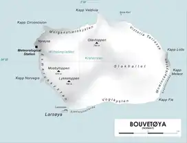
Map of Bouvetøya
References
- "Fie, Cape". Geographic Names Information System. United States Geological Survey. Retrieved 2012-03-22.
- "Prof. Dr. phil., Dr. med. h. c. Carl Chun". University of Leipzig. Retrieved November 1, 2016.
- "Norvegia-ekspedisjonene". Store norske leksikon. Retrieved November 1, 2016.
![]() This article incorporates public domain material from the United States Geological Survey document: "Fie, Cape". (content from the Geographic Names Information System)
This article incorporates public domain material from the United States Geological Survey document: "Fie, Cape". (content from the Geographic Names Information System)
This article is issued from Wikipedia. The text is licensed under Creative Commons - Attribution - Sharealike. Additional terms may apply for the media files.
