Cape York Peninsula tropical savanna
The Cape York Peninsula tropical savanna is a tropical grasslands, savannas, and shrublands ecoregion in northern Australia. It occupies the Cape York Peninsula in Queensland, mainland Australia's northernmost point.[2] It is coterminous with the Cape York Peninsula (code CYP),[3] an interim Australian bioregion.[4]
| Cape York Peninsula tropical savanna | |
|---|---|
.jpg.webp) | |
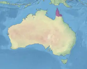 Map of the Cape York Peninsula tropical savanna ecoregion. | |
| Ecology | |
| Realm | Australasian |
| Biome | tropical and subtropical grasslands, savannas, and shrublands |
| Borders | Carpentaria tropical savanna, Einasleigh Uplands savanna, and Queensland tropical rain forests |
| Geography | |
| Area | 121,160 km2 (46,780 sq mi) |
| Country | Australia |
| States | Queensland and Torres Strait Regional Authority |
| Conservation | |
| Conservation status | Relatively stable/intact |
| Protected | 35,713 km² (29%)[1] |
| Cape York Peninsula Queensland | |||||||||||||||
|---|---|---|---|---|---|---|---|---|---|---|---|---|---|---|---|
 | |||||||||||||||
| Area | 122,564.57 km2 (47,322.4 sq mi) | ||||||||||||||
| |||||||||||||||
Geography
The ecoregion covers the northern portion of the Cape York Peninsula, along with the adjacent Torres Strait Islands. It is bounded by the Carpentaria tropical savanna ecoregion to the southwest, Einasleigh Uplands savanna to the south, and Queensland tropical rain forests to the southeast.
The west of the region is dominated in the south by an extensive Tertiary sand sheet dissected by the drainage systems of the Holroyd Plain, the Tertiary laterite of the Weipa Plateau, and the low rises of Mesozoic sandstones, while the northern section consists of the Weipa Plateau together with extensive coastal plains along the Gulf of Carpentaria. To the east lie aeolian dunefields.[5] Along the eastern margin, the geology of the Coen-Yambo Inlier is complex, with volcanic, metamorphic and acid intrusive rocks.[5] The subregion of the Battle Camp Sandstones, formed from deeply dissected plateaus, lies in the south of the region,[5] with the Laura Lowlands, composed of sands and silts, and colluvial and alluvial clays, lying adjacent.[5]
Climate
The climate is tropical, humid or maritime, with rainfall varying from 1000 mm to 1600 mm, including some high-rainfall areas at high altitudes.[5]
Flora
The vegetation mainly consists of woodlands, heathlands, sedgelands, vine forests (including both semi-deciduous vine forests on the eastern ranges and deciduous vine thickets on western slopes). Mangrove forests are found in the north east and along the estuaries on the coasts.[5]
Subregions
In the IBRA system, Cape York Peninsula (CYP) has nine sub-regions:[6]
| IBRA regions and subregions: IBRA7 | ||||
|---|---|---|---|---|
| IBRA subregion | IBRA code | Area | ||
| ha | acres | |||
| Coen-Yambo Inlier | CYP01 | 2,312,126 | 5,713,390 | |
| Starke Coastal Lowlands | CYP02 | 512,498 | 1,266,410 | |
| Cape York-Torres Strait | CYP03 | 94,367 | 233,190 | |
| Jardine-Pascoe Sandstones | CYP04 | 1,444,223 | 3,568,750 | |
| Battle Camp Sandstones | CYP05 | 504,409 | 1,246,420 | |
| Laura Lowlands | CYP06 | 1,791,228 | 4,426,220 | |
| Weipa Plateau | CYP07 | 2,848,753 | 7,039,420 | |
| Northern Holroyd Plain | CYP08 | 2,464,074 | 6,088,860 | |
| Coastal Plains | CYP09 | 284,780 | 703,700 | |
Protected areas
Protected areas in the ecoregion include Alwal National Park, Binirr National Park, Cape Melville National Park, Jack River National Park, Jardine River National Park, Kulla National Park, Lakefield National Park, Olkola National Park, Oyala Thumotang National Park, and Wuthathi (Shelburne Bay) National Park.
External links
- "Cape York Peninsula tropical savanna". Terrestrial Ecoregions. World Wildlife Fund.
References
- Eric Dinerstein, David Olson, et al. (2017). An Ecoregion-Based Approach to Protecting Half the Terrestrial Realm, BioScience, Volume 67, Issue 6, June 2017, Pages 534–545; Supplemental material 2 table S1b.
- "Cape York Peninsula tropical savanna". Terrestrial Ecoregions. World Wildlife Fund.
- "Interim Biogeographic Regionalisation for Australia (IBRA7) regions and codes". Department of Sustainability, Environment, Water, Population and Communities. Commonwealth of Australia. 2012. Retrieved 13 January 2013.
- "Interim Biogeographic Regionalisation for Australia, Version 7: regions" (PDF). Retrieved 6 May 2018.
- Environment Australia. "Revision of the Interim Biogeographic Regionalisation for Australia (IBRA) and Development of Version 5.1 - Summary Report". Department of the Environment and Water Resources, Australian Government. Archived from the original on 4 September 2006. Retrieved 6 May 2018. Cite journal requires
|journal=(help) - "IBRA7 subregions and codes" (PDF). Retrieved 6 May 2018.