Carnegie (ship)
The Carnegie was a brigantine yacht, equipped as a research vessel, constructed almost entirely from wood and other non-magnetic materials to allow sensitive magnetic measurements to be taken for the Carnegie Institution's Department of Terrestrial Magnetism. She carried out a series of cruises from her launch in 1909 to her destruction by an onboard explosion while in port in 1929. She covered almost 300,000 miles (500,000 km) in her twenty years at sea.[1]
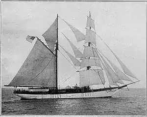 Carnegie on her first cruise | |
| History | |
|---|---|
| Name: | Carnegie |
| Owner: | Carnegie Institution |
| Builder: | Tebo Yacht Yard, Brooklyn |
| Cost: | US$115,000 |
| Launched: | June 12, 1909 |
| Fate: | Destroyed by fire November 29, 1929 |
| Notes: | Designed by Henry J. Gielow |
| General characteristics | |
| Tonnage: | 323 tons |
| Displacement: | 568 tons |
| Length: | 155 ft 6 in (47.40 m) |
| Beam: | 33 ft (10 m) |
| Draft: | 12 ft 7 in (3.84 m) |
| Installed power: | 150 horsepower |
| Propulsion: | Producer gas engine |
| Sail plan: | Brigantine |

Construction
Louis Agricola Bauer, the first director of the Department of Terrestrial Magnetism at the Carnegie Institution, wanted to focus on acquiring oceanic magnetic data to improve the understanding of the Earth's magnetic field.[2] After an experiment in which the brigantine Galilee was adapted by removing as much magnetic material as possible, it became clear that a new entirely non-magnetic ship was needed. After convincing the institution's board, Bauer set about getting such a vessel built. The Carnegie was designed by naval architect Henry J. Gielow and built at the Tebo Yacht Basin Company yard in Brooklyn, New York. Gielow's design minimised the amount of magnetic materials used in its construction and fittings. Locust trunnels were used to hold together the timbers with the help of some bronze or copper bolts.[1] The anchors were made of bronze and were attached to 11 inches (28 cm) hemp cables. A reserve engine was required to increase manoeuvrability and allow passage through the doldrums, so Carnegie was fitted with a producer gas engine, made mainly of copper and bronze, using coal as a fuel. She cost $115,000 (about 10 million dollars today) to build.[2]
Carnegie was 155.5 feet (47.4 m) long with a beam of 33 feet (10 m). She was rigged as a brigantine, with square sails on the foremast, giving a total sail area of 12,900 square feet (1,200 m2).[1] The most distinctive feature was the observation deck, with its two observing domes made of glass in bronze frames. This allowed observations to be made under all weather conditions.[2]
Cruises
Between 1909 and 1921 Carnegie carried out 6 cruises, including one where she managed the fastest circumnavigation of Antarctica by a sailing vessel, in 118 days,[2] a testing voyage where thirty icebergs were sighted on a single day. For the last four of Carnegie's cruises, the ship was commanded by Captain James P. Ault. From 1921 to 1927 Carnegie was laid up for an extensive refurbishment, including new deck timbers and a thicker copper hull. The old producer gas engine was replaced with a gasoline fuelled one. In 1928 Carnegie set off on the seventh cruise, which was intended to take three years.[1] Soundings taken during this voyage discovered the Carnegie Ridge off Ecuador.[3]
Destruction
After completing 43,000 miles (69,000 km) of the planned voyage, Carnegie put into the port of Apia, Samoa for supplies on 28 November 1929. While refuelling with gasoline there was an explosion, which mortally wounded Captain Ault and killed the cabin boy. The Carnegie burnt to the waterline within a few hours.[1]
Scientific legacy
The Carnegie carried a wide range of oceanographic, atmospheric and geomagnetic instrumentation and many scientists were associated with its findings and analysis, notably Harald Sverdrup, Roger Revelle and Scott Forbush (who escaped the fire that destroyed the ship in 1929).[4]
Geomagnetism
By 1930 the Department of Terrestrial Magnetism had enough data to be able to produce a much better view of Earth's magnetic field than had previously been available.[2] The loss of Carnegie left a void in capability to collect oceanic magnetic data. By 1951 world magnetic charts were badly flawed. As a result the U.S. Navy Hydrographic Office initiated Project Magnet, an airborne program to collect magnetic data world wide.[5] The introduction of the proton precession magnetometer enabled magnetic data collection from steel-hulled ships routine by 1957 making the extreme measures used for Carnegie unnecessary.[6]
Atmospheric electricity
The atmospheric electrical measurements carried out aboard Carnegie are of enduring and fundamental importance in understanding the balance of electric current flow in the atmosphere, the system known as the global atmospheric electric circuit. Most significantly, the results showed that the atmospheric electric field - a quantity always present away from thunderstorms - shows a characteristic daily variation which was independent of the position of the ship. This is known as the Carnegie curve.[7]
See also
References
- Bunker, J. (2004). "Sailing the Magnetic Fields: Carnegie, a seagoing observatory, plotted the forces that send compasses awry". Department of Terrestrial Magnetism. Retrieved 25 August 2010.
- Gubbins, D.; Herrero-Bervera, E. (2007). Encyclopedia of geomagnetism and paleomagnetism. Encyclopedia of earth sciences. Springer. p. 58. ISBN 978-1-4020-3992-8. Retrieved 25 August 2010.
- National Geospatial-intelligence Agency (4 June 2010). "Undersea Features History". Archived from the original on 9 July 2013. Retrieved 25 August 2010.
- Shor, Elizabeth Noble. (1978). Scripps Institution of Oceanography : probing the oceans 1936-1976. Tofua Press. ISBN 0-914488-17-1. OCLC 191970747.
- Lawyer, Lee C.; Bates, Charles C.; Rice, Robert B. (2001). Geophysics in the Affairs of Mankind: A Personalized History of Exploration. Tulsa, OK: Society of Exploration Geophysicists. pp. 89–90. ISBN 1560800879. LCCN 00027649. Retrieved 2 August 2020.
- Magnetics Division (1970). U.S. Naval Oceanographic Office Geomagnetic Surveys (IR No. 70-18) (PDF) (Report). Washington, D.C.: Hydrographic Surveys Department, U.S. Naval Oceanographic Office. p. I-1. Retrieved 2 August 2020.
- Harrison, R. Giles (2013-03-01). "The Carnegie Curve". Surveys in Geophysics. 34 (2): 209–232. doi:10.1007/s10712-012-9210-2. ISSN 1573-0956.
External links
- . Encyclopedia Americana. 1920.
- Magnetic Survey Yacht Carnegie (International Marine Engineering, February 1909)