Carolina Forest, South Carolina
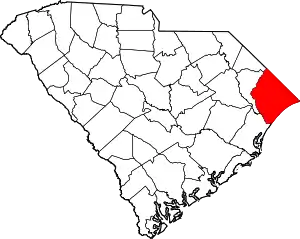
Carolina Forest is an unincorporated community in Horry County, South Carolina, United States. It is located west of Myrtle Beach and east of Conway in an area planned by International Paper in the late 1990s. Most of the development follows the Carolina Forest Master Plan, developed cooperatively between International Paper and the Horry County Government.
Carolina Forest, South Carolina | |
|---|---|
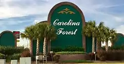
 Sign at the entrance to Carolina Forest at the intersection of US 501 and Carolina Forest Boulevard | |
 Carolina Forest, SC  Carolina Forest, SC | |
| Coordinates: 33°45′29″N 78°58′1″W | |
| Country | United States |
| State | South Carolina |
| County | Horry |
| Area | |
| • Total | 25.4 sq mi (65.7 km2) |
| • Land | 24.7 sq mi (63.9 km2) |
| • Water | 1.1 sq mi (2.8 km2) |
| Elevation | 39 ft (12 m) |
| Population (2014 est.) | |
| • Total | 33,966 |
| • Density | 321/sq mi (124.1/km2) |
| Time zone | UTC-5 (EST) |
| ZIP Code | 29579 |
| Area code(s) | 843 |
Geography
Carolina Forest is situated west of the Intracoastal Waterway; between U.S. Route 501 and International Drive. Carolina Forest was developed in and around existing Longleaf Pine forests and savannas, within the Waccamaw River watershed, part of the greater lower watershed of the Pee Dee River. The topography of the region between the Waccamaw River and the Intracoastal Waterway is spotted with Carolina Bays, which are elliptical-shaped depressions in the land, often filled with thick vegetation and rich in biodiversity.
History
Carolina Forest was once part of a larger tract of land in eastern Horry County called the Buist Tract. Originally owned by Burroughs & Chapin, International Paper bought the 30,000-acre (121 km2) Buist Tract in 1937. It was used as part of the Conway Bombing and Gunnery Range during World War II. In 1960, the company donated part of the tract for what is now Coastal Carolina University (located several miles away from Carolina Forest). In 1989, approximately 9,000 acres (36 km2) north of Carolina Forest were donated to the state to form the Lewis Ocean Bay Heritage Preserve.
In June 1994, Kylee Mueller sold 125 acres (0.51 km2) of the remaining 21,000 acres (85 km2) of the Buist Tract to Horry County Schools for development of Carolina Forest Elementary School, Carolina Forest Middle School, and Carolina Forest High School. In addition, 350 acres (1.4 km2) were sold to form a golf course and residential property.
By the end of 1994, International Paper began to sell more of its land. Due to the lack of funding from other sources for road infrastructure, the first 1.25 miles (2.01 km) of Carolina Forest Boulevard were completed by November 1995 by International Paper. Further expansions of both Carolina Forest Boulevard and River Oaks Drive (creating an 11-mile (18 km) loop) would open up 11,000 acres (45 km2) to development west of the Intracoastal Waterway. Carolina Forest Boulevard was completed in December 1996, with River Oaks Drive being completed in December 1997.[1]
On December 2, 1997, Horry County council voted to freeze zoning rules in an 11 square miles (28 km2) area of Carolina Forest for 20 years in exchange for land to build parks and roads in an 8–3 vote on the development agreement. An estimated 35,000 people would live in the 7,073 acres (29 km2) covered by the agreement. In the agreement, Horry County did not require International Paper to widen Carolina Forest Boulevard or River Oaks Drive to four lanes. Land would be given to the county at no cost for the then-future SC Highway 31 north and south of the Robert Grissom Parkway bridge. Approximately 140 acres (0.57 km2) was set aside for future schools, which would include Ocean Bay Elementary and Middle Schools. Because nearly half of Carolina Forest was open space, the area was exempt from future open space directives set by Horry County.[2]
According to the 2010 census, Carolina Forest's population increased from 3400 in 2000 to 21,000.[3]
Subdivisions
Source:[4]
- Alta Surf
- Amherst
- Ashford Estates
- Ashley Park
- Avalon
- Bay Meadows
- Bella Vita
- BelleGrove Preserve
- Berkshire Forest
- Black Creek Plantation
- Brookberry
- Brighton Lakes
- Brightwater
- Canterbury
- Carolina Willows
- Clear Pond
- Covington Lake
- Covington Lake East
- Carolina Waterway Plantation
- Emerald Forest
- Fairways
- Garden Homes
- Indigo Bay
- Inverness
- Legends
- Myrtle Beach National
- Oakmont Village
- Ocean Bay Townhomes
- Perry Place
- Plantation Lakes
- River Landing
- River Oaks
- Sago Plantation
- Sawgrass East
- Seaside Grove
- Southcreek
- Southgate
- Spring Lake
- Summerlyn
- The Battery
- The Bluffs
- The Cloisters
- The Farm
- The Parks
- The Fountains
- The Reserve
- The Vinings
- Turnberry
- Turning Pines
- Village of Dreams
- Walkers Woods
- Waterbridge
- Waterford Plantation
- Waterway Palms Plantation
- Waterway Village
- Westwood Estates
- Windsor Green
Education
Carolina Forest has a public library, a branch of the Horry County Memorial Library.[5]
References
- "IP Asks Permission to Lengthen Road," Mike Soraghan, The Sun News, July 4, 1996
- "Horry County Approves Carolina Forest Pact," Mike Soraghan, The Sun News, December 3, 1997
- "Carolina Forest community hoping for benefits from redistricting," Brad Dickerson, The Sun News, June 16, 2011
- "Carolina Forest Subdivisions".
- "Locations & Hours". Greenville County Library System. Retrieved 8 June 2019.
External links
| Wikimedia Commons has media related to Carolina Forest, South Carolina. |
