Castrovirreyna Province
The Castrovirreyna Province is one of seven provinces located in the Huancavelica Region of Peru. The capital of this province is the city of Castrovirreyna.
Castrovirreyna | |
|---|---|
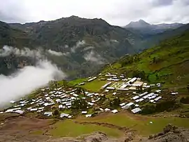 Awqa Urqu (in the background, on the right) as seen from Cochamarca (Quchamarka) in the southwest | |
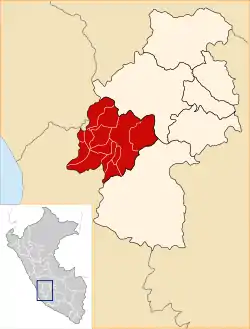 Location of Castrovirreyna in the Huancavelica Region | |
| Country | Peru |
| Region | Huancavelica |
| Capital | Castrovirreyna |
| Area | |
| • Total | 3,984.62 km2 (1,538.47 sq mi) |
| Population (2005 census) | |
| • Total | 20,018 |
| • Density | 5.0/km2 (13/sq mi) |
| UBIGEO | 0904 |
Geography
The Chunta mountain range traverses the province. Some of the highest peaks of the province are listed below:[1]
- Allpa Qutu
- Allqa Q'asa
- Ananta
- Anta Mach'ay
- Artisa
- Awqa Urqu
- Awqay Pata
- Chuqi Warmi
- Ch'aqra Punta
- Hatun Pukyu
- Ichhu Rutuna
- Kuntur Wamani
- Kuntur Wamani (Castr.)
- Kunturillu
- Kuyuq Urqu
- Mach'ay Pata
- Pata Pata
- Paychi Urqu
- Pichqa Pukyu
- Pilluni
- Pinqullu
- Pirwalla
- Puka Punta
- Puka Q'asa
- Puma Pukyu
- Phiruru Urqu
- Qarwa Pampa
- Qarwa K'anti
- Qarwa Q'asa
- Qarwarasu
- Qucha Q'asa
- Qusqu
- Q'ara Wayuna
- Ranra Urqu
- Saqsa Punta
- Sukullu
- Suyt'u Sura
- Tuku Wasi
- Urququcha
- Wallu Q'asa
- Wamanripayuq
- Waraquyuq
- Wayllachayuq
- Wayra Q'asa
- Yana Pampa
- Yana Ranra
- Yana Urqu
- Yanaqucha
- Yawar Q'asa
- Yawarqucha
- Yuraq Q'asa
Political division
The province is divided into thirteen districts, which are:
- Arma (Arma)
- Aurahua (Aurahua)
- Capillas (Capillas)
- Castrovirreyna (Castrovirreyna)
- Chupamarca (Chupamarca)
- Cocas (Cocas)
- Huachos (Huachos)
- Huamatambo (Huamatambo)
- Mollepampa (Mollepampa)
- San Juan (San Juan)
- Santa Ana (Santa Ana)
- Tantara (Tantara)
- Ticrapo (Ticrapo)
Ethnic groups
The province is inhabited by indigenous citizens of Quechua descent. Spanish is the language which the majority of the population (77.20%) learnt to speak in childhood, 22.30% of the residents started speaking using the Quechua language (2007 Peru Census).[2]
See also
References
- escale.minedu.gob.pe/ UGEL map Castrovirreyna Province (Huancavelica Region)
- inei.gob.pe Archived January 27, 2013, at the Wayback Machine INEI, Peru, Censos Nacionales 2007
| |
|---|---|
This article is issued from Wikipedia. The text is licensed under Creative Commons - Attribution - Sharealike. Additional terms may apply for the media files.