Cat Tail Brook
Cat Tail Brook is a tributary of Rock Brook in central New Jersey in the United States.
| Cat Tail Brook | |
|---|---|
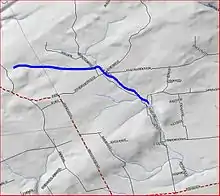 Map of Cat Tail Brook | |
| Location | |
| Country | United States |
| Physical characteristics | |
| Source | |
| • coordinates | 40°26′26″N 74°46′2″W |
| Mouth | |
• coordinates | 40°25′55″N 74°43′44″W |
• elevation | 220 ft (67 m) |
| Basin features | |
| Progression | Rock Brook, Beden Brook, Millstone River, Raritan River, Atlantic Ocean |
| River system | Raritan River system |
Course
Cat Tail Brook originates in Sourland Mountain at 40°26′26″N 74°46′2″W.[1] It flows southeast until it meets Rock Brook at the edge of Sourland Mountain at 40°25′55″N 74°43′44″W.[1]
See also
References
- "GNIS Detail - Cat Tail Brook". USGS. Retrieved 21 July 2010.
This article is issued from Wikipedia. The text is licensed under Creative Commons - Attribution - Sharealike. Additional terms may apply for the media files.
