Catarina, San Marcos
Catarina is a municipality in the San Marcos department of Guatemala. It is recognised as different municipality on 20 January 1925, when it split from Malacatán municipality.
Catarina | |
|---|---|
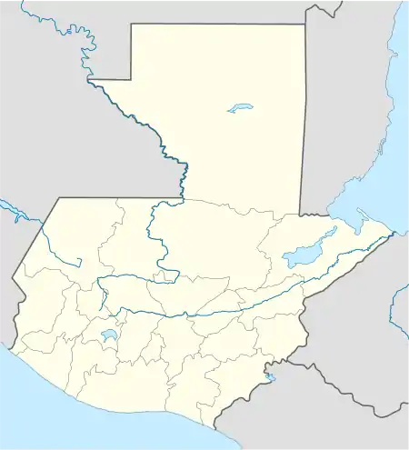 Catarina Location in Guatemala | |
| Coordinates: 14°50′57″N 92°04′39″W | |
| Country | |
| Department | |
| Government | |
| • Mayor | Fulbio Pérez[1] (CREO) |
| Climate | Am |
Climate
Catarina has tropical monsoon climate (Köppen: Am).
| Climate data for Catarina | |||||||||||||
|---|---|---|---|---|---|---|---|---|---|---|---|---|---|
| Month | Jan | Feb | Mar | Apr | May | Jun | Jul | Aug | Sep | Oct | Nov | Dec | Year |
| Average high °C (°F) | 33.0 (91.4) |
33.5 (92.3) |
34.1 (93.4) |
33.7 (92.7) |
33.0 (91.4) |
31.6 (88.9) |
32.1 (89.8) |
32.2 (90.0) |
31.7 (89.1) |
31.5 (88.7) |
31.9 (89.4) |
32.3 (90.1) |
32.6 (90.6) |
| Daily mean °C (°F) | 25.8 (78.4) |
26.3 (79.3) |
27.1 (80.8) |
27.6 (81.7) |
27.3 (81.1) |
26.4 (79.5) |
26.5 (79.7) |
26.7 (80.1) |
26.4 (79.5) |
26.2 (79.2) |
26.0 (78.8) |
25.8 (78.4) |
26.5 (79.7) |
| Average low °C (°F) | 18.7 (65.7) |
19.1 (66.4) |
20.2 (68.4) |
21.5 (70.7) |
21.7 (71.1) |
21.2 (70.2) |
21.0 (69.8) |
21.2 (70.2) |
21.2 (70.2) |
20.9 (69.6) |
20.2 (68.4) |
19.3 (66.7) |
20.5 (69.0) |
| Average precipitation mm (inches) | 14 (0.6) |
20 (0.8) |
55 (2.2) |
166 (6.5) |
386 (15.2) |
581 (22.9) |
455 (17.9) |
513 (20.2) |
636 (25.0) |
535 (21.1) |
135 (5.3) |
32 (1.3) |
3,528 (139) |
| Source: Climate-Data.org[2] | |||||||||||||
Geographic location
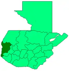
Catarina is surrounded by San Marcos Department municipalities.[3]
See also
 Guatemala portal
 Geography portal
References
- "San Marcos elige autoridades municipales". Prensa Libre (in Spanish). Guatemala. 8 September 2015. Retrieved 8 September 2015.CS1 maint: ref=harv (link)
- "Climate: Catarina". Climate-Data.org. Retrieved 5 September 2015.
- SEGEPLAN (n.d.). "Municipios del departamento de San Marcos". Secretaría General de Planificación (in Spanish). Archived from the original on 10 July 2015.CS1 maint: ref=harv (link)
External links
- Some information (in Spanish)
This article is issued from Wikipedia. The text is licensed under Creative Commons - Attribution - Sharealike. Additional terms may apply for the media files.