Cathedral, Colorado
Cathedral is an unincorporated community and a census-designated place (CDP) located in and governed by Hinsdale County, Colorado, United States. The population of the Cathedral CDP was 14 at the United States Census 2010.[4] The Powderhorn post office (Zip Code 81243) serves the area.[3]
Cathedral, Colorado | |
|---|---|
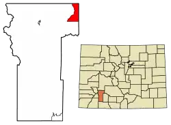 Location of the Cathedral CDP in Hinsdale County, Colorado. | |
 Cathedral Location of the Cathedral CDP in the United States. | |
| Coordinates: 38°05′01″N 107°01′50″W[1] | |
| Country | |
| State | |
| County | Hinsdale County |
| Government | |
| • Type | unincorporated community |
| Area | |
| • Total | 21.279 sq mi (55.113 km2) |
| • Land | 21.279 sq mi (55.113 km2) |
| • Water | 0.000 sq mi (0.000 km2) |
| Elevation | 9,249 ft (2,819 m) |
| Population (2010) | |
| • Total | 14 |
| • Density | 0.7/sq mi (0.3/km2) |
| Time zone | UTC-7 (MST) |
| • Summer (DST) | UTC-6 (MDT) |
| ZIP Code[3] | Powderhorn 81243 |
| Area code(s) | 970 |
| GNIS feature[2] | Cathedral CDP |
Geography
Cathedral is located in the northeast corner of Hinsdale County on the east side of Cebolla Creek, a north-flowing tributary of the Gunnison River. The community is at the junction of County Roads 50 and 45. County Road 50 leads southwest (upstream) 15 miles (24 km) to Colorado State Highway 149 at Slumgullion Pass, from which point Lake City, the Hinsdale County seat, is 9 miles (14 km) to the northwest. County Road 50 also leads north (downstream) from Cathedral into Gunnison and eventually via County Road 27 16 miles (26 km) to Highway 149 at Powderhorn.
The Cathedral CDP has an area of 13,619 acres (55.113 km2), all land.[1]
Demographics
The United States Census Bureau initially defined the Cathedral CDP for the United States Census 2010.
| Year | Pop. | ±% |
|---|---|---|
| 2010 | 14 | — |
| 2020 | — | |
| Source: United States Census Bureau | ||
See also
- Outline of Colorado
- State of Colorado
- Colorado cities and towns
- Colorado counties
References
- "State of Colorado Census Designated Places - BAS20 - Data as of January 1, 2020". United States Census Bureau. Retrieved December 22, 2020.
- "U.S. Board on Geographic Names: Domestic Names". United States Geological Survey. Retrieved December 22, 2020.
- "Zip Code 81243 Map and Profile". zipdatamaps.com. 2020. Retrieved December 22, 2020.
- "2010: DEC Summary File 1". United States Census Bureau. Retrieved December 22, 2020.
External links
Municipalities and communities of Hinsdale County, Colorado, United States | ||
|---|---|---|
| Town | 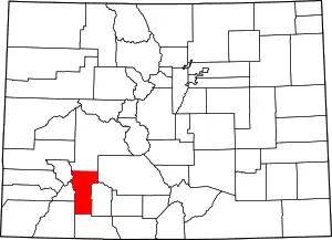 Map of Colorado highlighting Hinsdale County | |
| CDPs | ||
| Ghost town | ||
| ||
