Cavers Castle
Cavers Castle, also known as Cavers House, is a ruined tower house located at Cavers, Scottish Borders, Scotland.[1] Cavers Castle was a much extended tower house of the Douglas family dating back to the 15th or 16th century, and built upon the site of an earlier stronghold of the Balliols. It was repeatedly attacked during the 16th century wars with England, and substantially remodelled in the 17th century to form a mansion house, itself extended and remodelled in baronial style by Peddie and McKay in the 1890s. It was eventually deroofed and partially demolished in the 1950s, and was sold most recently in 2019. There are developing plans to restore the building.
| Cavers Castle | |
|---|---|
| Cavers, Scottish Borders, Scotland | |
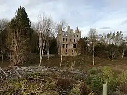 Ruins of Cavers House, which incorporates parts of former castle. | |
| Coordinates | 55°25′51″N 2°43′39″W |
| Site information | |
| Condition | Ruined |
History
The lay lands and barony of Cavers first appear in the hands of the Balliol family in 1268, when Alexander de Balliol of Cavers is first mentioned in documents.[2] The church lands of Cavers, by comparison, were held by Jedburgh Abbey from early in the reign of King William the Lion.[3]
During the Scottish Wars of Independence, Alexander Balliol of Cavers was captured – perhaps at Dunbar in 1296, and in return for his release fought for King Edward I of England from 1297,[4] although the English kept his son in the Tower of London as insurance for his good behaviour.[5] In 1311 the castle was occupied by an English garrison,[6] but there are no mentions of it after the fall of Jedburgh Castle to the Scots in 1314. The English presentation of a priest to Cavers church in 1319 suggests the area remained subject to English authority.[7] A safe conduct was issued at Cavers by James Douglas in 1321 to permit a group of English cavalry to enter Scotland, but the castle is not specifically mentioned.[8] In 1358 Cavers was held by the Earl of Mar,[9] the Balliols having been forfeited of their estates for their opposition to the regime of Robert the Bruce.[10] In 1368 the Earl of Douglas, elsewhere at this date styled lord of the barony of Cavers[11] was granted lands in the barony of Cavers in a document signed there,[12] indicating that the buildings of a baronial centre of sorts had been erected there by this date. In 1397, Cavers was in the hands of Isabel, Countess of Mar,[13] the niece of Earl Thomas, and in the early 15th century, she granted the lands and barony of Cavers to her nephew, Archibald Douglas,[14] the younger of the two illegitimate sons of James, Earl of Douglas.[15] This was disputed by King Robert III, who granted them to Sir David Fleming of Biggar,[16] as well as by George Douglas, Earl of Angus,[16] who had been granted the rights of Cavers held by Sir James Sandilands.[16] Archibald had his grant confirmed by King James I in 1412,[17] and became heritable Sheriff of Roxburgh/Teviotdale[18] – these two titles were used interchangeably.
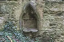
Given the general context of baronial castle building in Scotland and the Borders at this time, and the wealth and status of the Balliols, one might expect a ditched manorial centre, which may have been built, and defended, partially in timber.[19] However, nothing remains today of the castle which can be conclusively identified as pre-dating the Douglas period of ownership. Although a mid-13th-century piscina[20] has been built into the tower, it was set in place with cement, dating this event firmly to the late 19th or early 20th century.
Again, given the general context, it is likely that Archibald (last mentioned in 1455) was the builder of the tower house which formed the core of the castle up until its demolition in the 1950s. On the basis of general style, the tower is dated to the 15th or early 16th century, and the “castrum” of Cavers is first mentioned in a charter of 1511.[20] In 1523 Teviotdale was attacked by the English with its strongholds described as overthrown,[21] and again in 1542,[22] and during the Rough Wooing in 1544, and 1545.[23] It is likely that the tower of Cavers was attacked and damaged more than once during this process, but it is not specifically mentioned until 1545.[24] The small settlement of Cavers is not mentioned by name either. In 1547, after the battle of Pinkie, William Douglas of Cavers (the sixth laird) swore allegiance to King Edward VI along with the Kerr lairds of Ferniehirst and Cessford,[25] showing that the English were firmly in control of Teviotdale at this date.
The lairds of Cavers are not prominent in records at this time, being overshadowed by the Kerr Wardens of the Middle March, whose authority was military and cross-border. The domestic authority of the sheriff was perhaps less important. The tower house remained a significant building, being depicted as a tall tower, barmkin wall and ancillary courtyard buildings on Pont’s map of 1590 – 1600.[26] From the disbanding of the guard on the border by King James VI in 1621,[27] any remaining military function the castle may have had ceased, and from this date onwards it served primarily as the residence of the Douglas lairds.
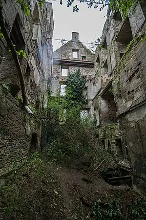 Inside the tower
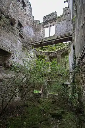 Inside the castle wing
Sir William Douglas, ninth laird of Cavers, was a supporter of the National Covenant,[28] and the Hawick Covenant, which he signed in 1638, was kept at Cavers.[29] Development of the castle after 1603 is as yet unclear, but it is clear that the estate, like many others suffered financially during the latter 17th and first half of the 18th century. The family also failed to flourish, with the 12th, 14th, 15th, and 16th lairds all being succeeded by brothers, and the 17th laird by a cousin.[30] The last of the direct male Douglas line died in 1878.[31] The military map drawn up by General William Roy of c1750 shows that the house was the centre of a large estate, but was not surrounded by much in the way of formal gardens.[32] The earliest photographs of Cavers House show that it had been much extended by the late 19th century, when the Palmer Douglas family had become lairds,[31] and domesticized to have the appearance of a large house, the old tower being completely subsumed. At this time the house was often leased out to guests along with shooting rights,[33] the family themselves preferring to reside at Midgard House from 1863.[33] Amongst people known to have worked at the house during the 19th century was the botanist John Scott, who served his horticultural apprenticeship at Cavers.[34]
In the 1890s, the house was remodelled in grand baronial style,[20] which was undoubtedly a further burden to a struggling estate, but the impact of both World Wars was substantial, and according to family records Archibald Palmer Douglas returned to Cavers House from Midgard in the 1940s, which was provided with electricity in 1946 for the first time.[33] He died the following year, and his son James factored the estate on behalf of his grandmother until 1949.[33] Death duties resulted in the estate being broken up, and although James attempted to sell the house, he could not find a buyer, and after being deroofed, the house was used for explosives practice in 1954[20] before being sold off along with the rest of the broken-up estate. The old tower survives as a shell along with part of the attached mansion.
References
- Coventry, Martin (2015). The castles of Scotland : a comprehensive guide to more than 4,100 castles, towers, historic houses, stately homes and family lands (Fifth ed.). Prestonpans, Scotland. p. 28. ISBN 978-1-899874-55-2. OCLC 894611322.
- Dryburgh Liber, no 136
- RRS iii, no 150
- Brown, Michael (2004). The wars of Scotland, 1214-1371. Edinburgh: Edinburgh University Press. p. 193. ISBN 0-7486-1237-8. OCLC 55698013.
- Bain, Calendar (3); p25
- CDS iii, no 218
- Bain, Calendar (3); p123
- Bain, Calendar (3); p148
- Jack, Katy Samantha (2016). Decline and fall: the earls and earldom of Mar c.1281-1513 (PhD thesis). University of Stirling., chapter 7.
- Penman, Michael A. (2014). Robert the Bruce: King of Scots. New Haven. pp. 151–152. ISBN 978-0-300-14872-5. OCLC 871689437.
- Jack, Katy Samantha (2016). Decline and fall: the earls and earldom of Mar c.1281-1513 (PhD thesis). University of Stirling., p. 294, chapter 15.
- Robertson, Joseph; Grub, George (1847–1869). Illustrations of the topography and antiquities of the shires of Aberdeen and Banff. iv. Spalding Club. p. 160.
- Jack, Katy Samantha (2016). Decline and fall: the earls and earldom of Mar c.1281-1513 (PhD thesis). University of Stirling. p. 141.
- Jack, Katy Samantha (2016). Decline and fall: the earls and earldom of Mar c.1281-1513 (PhD thesis). University of Stirling., p. 174.
- Brown, Michael (1998). The Black Douglases : war and lordship in late Medieval Scotland, 1300-1455. East Linton, East Lothian, Scotland: Tuckwell Press. p. 109. ISBN 1-86232-036-5. OCLC 39914022.
- Jack, Katy Samantha (2016). Decline and fall: the earls and earldom of Mar c.1281-1513 (PhD thesis). University of Stirling., p. 175.
- Historical Manuscripts Commission, 7th Report, 727
- Bannatyne Club (1850), Publications, issue 97, volume 1; p336
- Brown, Michael (2009). Scottish baronial castles, 1250-1450. Hook, Adam. Oxford: Osprey Pub. pp. 4–5. ISBN 978-1-84603-286-8. OCLC 233939494.
- "Cavers House | Canmore". canmore.org.uk. Retrieved 2021-01-08.
- Morton, James (1832). The Monastic Annals of Teviotdale. p. 26.
- Morton, James (1832). The Monastic Annals of Teviotdale. p. 99.
- Morton, James (1832). The Monastic Annals of Teviotdale. pp. 99–102.
- Douglas, George (1899). A History of the Border Counties. William Blackwood and Sons. p. 286.
- Douglas, George (1899). A History of the Border Counties. William Blackwood and Sons. p. 289.
- "[Nithsdale; part of Teviotdale] - Pont 35 - Maps of Scotland". maps.nls.uk. Retrieved 2021-01-08.
- Groundwater, Anna (2010). "From Whitehall to Jedburgh: Patronage networks and the government of the Scottish Borders, 1603 to 1625". The Historical Journal. 53 (4): 871–893. doi:10.1017/S0018246X10000385. ISSN 0018-246X.
- Stewart, Duncan (1908). Covenanters of Teviotdale and neighbouring district. p. 18.
- Stewart, Duncan (1908). Covenanters of Teviotdale and neighbouring district. p. 17.
- Johnston, G Harvey (1907). The Heraldry of the Douglases. p. 32.
- Johnston, G Harvey (1907). The Heraldry of the Douglases. p. 34.
- "Explore georeferenced maps - Map images - National Library of Scotland". maps.nls.uk. Retrieved 2021-01-08.
- Private papers of the Palmer Douglas family, unpublished
- Murray, Katharine Maud Elisabeth. (2001). Caught in the web of words : James A.H. Murray and the Oxford English dictionary. New Haven: Yale University Press. p. 17. ISBN 0-300-08919-8. OCLC 47079364.
External links
- Historic Environment Scotland. "Cavers House (55298)". Canmore.
- Cavers Castle on The Castle Guy