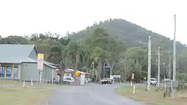
Cawarral
Cawarral is a rural town and locality in the Livingstone Shire, Queensland, Australia.[2][3] In the 2016 census the locality of Cawarral had a population of 831 people.[1]
| Cawarral Queensland | |||||||||||||||
|---|---|---|---|---|---|---|---|---|---|---|---|---|---|---|---|
 Cawarral, 2016 | |||||||||||||||
 Cawarral | |||||||||||||||
| Coordinates | 23.2562°S 150.6735°E | ||||||||||||||
| Population | 831 (2016 census locality)[1] | ||||||||||||||
| • Density | 16.042/km2 (41.55/sq mi) | ||||||||||||||
| Postcode(s) | 4702 | ||||||||||||||
| Area | 51.8 km2 (20.0 sq mi) | ||||||||||||||
| Time zone | AEST (UTC+10:00) | ||||||||||||||
| Location |
| ||||||||||||||
| LGA(s) | Shire of Livingstone | ||||||||||||||
| State electorate(s) | Keppel | ||||||||||||||
| Federal Division(s) | Capricornia | ||||||||||||||
| |||||||||||||||
History
Cawarral State School opened on 13 July 1874.[4]
In the 2011 census, Cawarral had a population of 726 people.[5]
In the 2016 census the locality of Cawarral had a population of 831 people.[1]
Education
Cawarral State School is a government primary (Prep-6) school for boys and girls at 125 Annie Drive (23.2539°S 150.6756°E).[6][7] In 2015, Cawarral State School had an enrolment of 87 students with 6 teachers (5 full-time equivalent).[8] In 2018, the school had an enrolment of 85 students with 7 teachers (6 full-time equivalent) and 9 non-teaching staff (5 full-time equivalent).[9]
There is no secondary school in Cawarral. The nearest secondary schools are Yeppoon State High School in Yeppoon to the north-east and Glenmore State High School in Kawana in Rockhampton to the south-west.[10]
Facilities

The Cawarral Cemetery is on the corner of Cemetery Road and Helena Lane (23.2630°S 150.6645°E) and is managed by the Livingstone Shire Council.[11]
References
- Australian Bureau of Statistics (27 June 2017). "Cawarral (SSC)". 2016 Census QuickStats. Retrieved 20 October 2018.

- "Cawarral – town in Livingstone Shire (entry 6690)". Queensland Place Names. Queensland Government. Retrieved 27 December 2020.
- "Cawarral – locality in Livingstone Shire (entry 49338)". Queensland Place Names. Queensland Government. Retrieved 27 December 2020.
- Queensland Family History Society (2010), Queensland schools past and present (Version 1.01 ed.), Queensland Family History Society, ISBN 978-1-921171-26-0
- Australian Bureau of Statistics (31 October 2012). "Cawarral (SSC)". 2011 Census QuickStats. Retrieved 24 July 2016.

- "State and non-state school details". Queensland Government. 9 July 2018. Archived from the original on 21 November 2018. Retrieved 21 November 2018.
- "Cawarral State School". Archived from the original on 19 March 2020. Retrieved 21 November 2018.
- "2015 School Annual Report" (PDF). Cawarral State School. Archived from the original (PDF) on 16 August 2016. Retrieved 24 July 2016.
- "ACARA School Profile 2018". Australian Curriculum, Assessment and Reporting Authority. Archived from the original on 27 August 2020. Retrieved 28 January 2020.
- "Queensland Globe". State of Queensland. Retrieved 2 February 2021.
- "Cemeteries". Livingstone Shire Council. Archived from the original on 11 August 2016. Retrieved 27 July 2016.
External links
| Wikimedia Commons has media related to Cawarral. |
- "Cawarral". Queensland Places. Centre for the Government of Queensland, University of Queensland.
