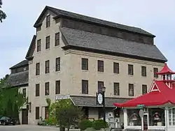
Cedarburg Mill
The Cedarburg Mill is a former gristmill on Cedar Creek in Cedarburg, Wisconsin United States. In 1844 Frederick Hilgen and William Schroeder built a wooden gristmill on the west bank of Cedar Creek in what would become the city of Cedarburg. It soon became clear that a new structure was needed, and Burchard Weber was employed as the architect and builder of the new mill. Stone for the new mill was quarried locally including from the creek bed. The east wing of the building was built first, followed by the main mill building which employed a large earthen ramp to move stone to higher levels, construction was completed in 1855.[2][3][4] At five stories high, the Cedarburg Mill was the tallest building in Cedarburg and cost $22,000 to construct. The mill could produce 120 barrels of flour each day, which was sold in a shop owned by Hilgen and Schroeder across the street.
Cedarburg Mill | |
 Cedarburg Mill | |
 Location | |
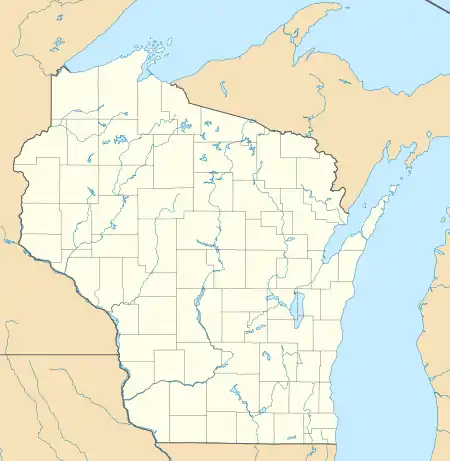
| Location | N70 W6340 Bridge Road or 215 E. Columbia Ave.[1] Cedarburg, Wisconsin |
|---|---|
| Coordinates | 43°17′48″N 87°59′10″W |
| Built | 1855 |
| Architect | Fredrick Hilgen, William Schroeder,[1] Burchard Weber |
| Architectural style | Vernacular Greek Revival |
| NRHP reference No. | 74000115[1] |
| Added to NRHP | May 8, 1974 |
1800s
The mill was immediately successful and following that success additional mills were built on Cedar Creek including the Hilgen and Wittenburg Woolen Mill in 1864 and the Excelsior Mill in 1871. During Wisconsin's "Great Indian Scare" of September 1862, the mill was used as a makeshift fortress by some residents in response to rumors of a Native American uprising in the state. 30,000 men were out of state, serving in the American Civil War, and would not be able to respond to such an uprising inflating residents fears. The rumors were ultimately false, however the rumor caused mass hysteria in state's population.[4] In 1881 the mill was the only one whose dam survived the severe flooding that spring, and a year later in 1882 the mill was sold to John Grundke.[4]
1900s
In 1901 the mill was sold to Christian, Louis, and William Ruck, and in 1913 Louis Ruck, the son of Christian Ruck bought out his family members and became the sole owner of the mill, the milldam and pond still bear the ruck name. The mill building was bought from Louis Ruck in January 1930 by the Cedarburg Supply Company and converted from hydropower to electric power.[4] From the 1960s through the 1970s a sewer carried waste oil including PCBs from Mercury Marines Cedarburg factory to the millpond resulting in dangerous levels of PCBs in both the mill pond and the entirety of Cedar Creek from the mill pond to its confluence with the Milwaukee River.[5][6] In 1974 the mill building was added to the U.S National Register of Historic Places.[3] In the 1990s the millpond was dredged removing the contaminated sediment.
2000s
In 2016 additional PCB remediation was completed in the mills raceway.[6] The mill is still owned by Cedarburg Supply Company, now known as Landmark Supply Co who occupies much of the first floor of the building. Other tenants include a brewpub and architecture firm.
See also
| Mill Name | Year Built | Products Produced | Notes |
|---|---|---|---|
| Concordia Mill | 1853 | Grain | Dam washed out and removed 1996 |
| Excelsior Mill, later Cedarburg Wire and Nail Factory | 1871 | Grain, lumber, drawn steel, hydroelectricity | |
| Columbia Mill | 1843 | Grain | Demolished |
| Cedarburg Mill | 1844 | Grain | Rebuilt 1855 with current stone structure |
| Hilgen and Wittenberg Woolen Mill | 1864 | Textiles |
References
- "National Register Information System". National Register of Historic Places. National Park Service. March 13, 2009.
- "Cedarburg Mill". Wisconsin Historical Society. Retrieved 2017-01-04.
- Anderson, Donald N. (1973-07-26). "Cedarburg Mill". NRHP Inventory-Nomination Form. National Park Service. Retrieved 2017-01-04.
- "Early history of Ozaukee County, Wisconsin". University of Wisconsin-Madison Libraries. Retrieved 2020-01-01.
- Writer, Richard Wronski, Tribune Staff. "QUAINT TOWN'S TAINTED CREEK TO GET CLEANUP". chicagotribune.com. Retrieved 2020-12-15.
- "CEDAR CREEK Site Profile". cumulis.epa.gov. Retrieved 2020-12-15.