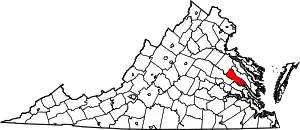
Central Garage, Virginia
Central Garage is a census-designated place (CDP) in King William County, Virginia, United States. The population as of the 2010 census was 1,318.[1]
Central Garage, Virginia | |
|---|---|
 Central Garage  Central Garage | |
| Coordinates: 37°44′38″N 77°7′53″W | |
| Country | United States |
| State | Virginia |
| County | King William |
| Area | |
| • Total | 4.9 sq mi (12.6 km2) |
| • Land | 4.8 sq mi (12.5 km2) |
| • Water | 0.04 sq mi (0.1 km2) |
| Elevation | 168 ft (51 m) |
| Population (2010) | |
| • Total | 1,318 |
| • Density | 274/sq mi (105.6/km2) |
| Time zone | UTC−5 (Eastern (EST)) |
| • Summer (DST) | UTC−4 (EDT) |
| Area code(s) | 804 |
| FIPS code | 51-14312 |
| GNIS feature ID | 1464687 |
Geography
The community is northwest of the center of King William County, around the junction of U.S. Route 360 and Virginia State Route 30. US 360 leads northeast 21 miles (34 km) to Tappahannock and southwest 23 miles (37 km) to Richmond, the state capital. VA 30 leads southeast 7 miles (11 km) to King William, the county seat, and northwest 21 miles (34 km) to U.S. Route 1 in Doswell.
According to the U.S. Census Bureau, the Central Garage CDP has a total area of 4.9 square miles (12.6 km2), of which 0.04 square miles (0.1 km2), or 0.81%, are water.[1]
References
- "Geographic Identifiers: 2010 Census Summary File 1 (G001), Central Garage CDP, Virginia". American FactFinder. U.S. Census Bureau. Archived from the original on February 13, 2020. Retrieved May 23, 2019.
- Virginia Trend Report 2: State and Complete Places (Sub-state 2010 Census Data)
- U.S. Geological Survey Geographic Names Information System: Central Garage, Virginia
- Virginia Department of Transportation-produced road map
This article is issued from Wikipedia. The text is licensed under Creative Commons - Attribution - Sharealike. Additional terms may apply for the media files.
