Cerro El Baúl
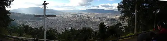
Cerro El Baúl, also known as El Baúl, is a forested lava dome overlooking the valley of Quetzaltenango.[1] It is located about 3 km north of the Almolonga volcano, at the south-eastern edge of the city of Quetzaltenango in Guatemala and is one of the city's last remaining green areas.
| Cerro El Baúl National Park | |
|---|---|
| Location | Quetzaltenango (department), Guatemala |
| Coordinates | 14°49′52″N 91°30′10″W |
| Area | 2.40 km2 (0.93 sq mi) |
| Elevation | 2,650 m (8,690 ft) |
| Established | Acuerdo Gubernativo 26-05-55 |
| Operator | Municipality of Quetzaltenango |
Cerro El Baúl covers an area of 2.40 km² and was declared a national park in 1955.[2] The park is under serious threat due to illicit extraction of trees and advancing urbanization crossing the park borders.[3]
References
- Bohnenberger, Otto H. "Los focos eruptivos cuaternarios de Guatemala". Guatemala: INSIVUMEH. Retrieved 2010-05-05.
- CONAP. "Listado de Áreas Protegidas (enero, 2011)" (in Spanish). conap.gob.gt. Archived from the original (xls) on 2011-10-08. Retrieved 2011-06-14.
- Prensa Libre. "Cerro El Baúl, otra reserva en peligro" (in Spanish). Archived from the original on 2008-12-06. Retrieved 2009-07-25.
This article is issued from Wikipedia. The text is licensed under Creative Commons - Attribution - Sharealike. Additional terms may apply for the media files.